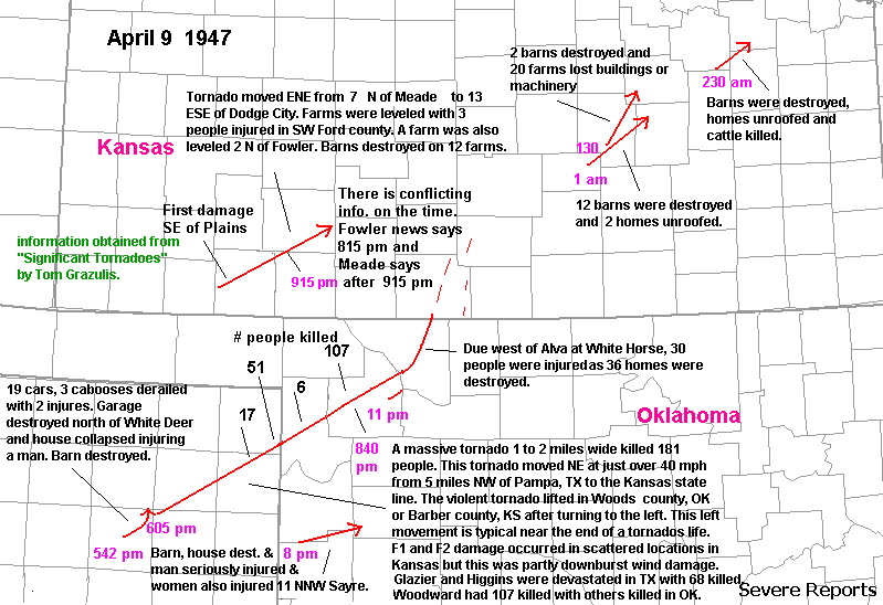
On April 9, 1947, a tornado touched down at 542
pm(2342 UTC), WSW of White
Deer, TX in the Texas panhandle.
The tornadic storm would go on to devastate parts of
the panhandle, northwest
Oklahoma and Kansas, resulting in 181
fatalities. After the White Deer tornado turned
north and lifted, another
tornado touched down 5 miles NW of Pampa.
The tornado passed 3 miles NW of Canadian. The
tornado widened to over
a mile in the northeast TX Panhandle. The
town of Glazier was completely destroyed with 15
people killed, and much
of Higgins, TX was destroyed with 51 fatalities.
Six people were killed in Oklahoma before the
tornado reached Woodward
as dozens of farms were destroyed 2 to 3
miles SE of Gage and Fargo. The tornado devastated
Woodward killing at
least 107 people in Woodward(from Siginficant
Tornadoes by Tom Grazulis). The damage path was 2
miles through Woodward.The
tornado started moving more to the
NNE after leaving Ellis county in Woods
county, 36 homes were destroyed
with 30 people injured. The tornado entered
Kansas just west of Hardtner before dissipating.
Weak tornadoes and downburst
activity continued well into Kansas with
the storm. A strong to violent tornado also occurred
in southwest Kansas
to the SW and S of Dodge City the same evening.
Yet another tornadic storm occurred south of the
Woodward storm. A map
containing these tornadoes can be found here.
Much of the information on this map was obtained
from "Significant Tornadoes"
by Tom Grazulis.
At 1530
UTC April 9, a surface warm front stretched from central NM to
just S of Lubbock to N of Dallas. This front was
nearly stationary from NE TX into Mississippi.
Surface low pressure was
located in E. Utah, with a pacific cold front
extending S into far
eastern AZ. Another low-level baroclinic zone
was noted over southern KS. Fog was common north
of the warm front in NE NM and the TX panhandle with
visibilities 1/8 mile
at Amarillo and Pampa and 1/4 mile at Clayton,
NM and Childress, TX.
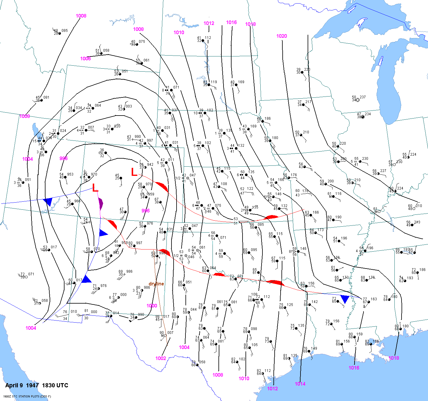
By 1830
UTC the warm front was stretched from near Santa Fe, NM to
just S of Tumumcari, NM to just S of Childress
to S of Texarkana, AR. The surface visibility was
zero at Pampa and 1/8
mile at Amarillo. A warm front or stationary
front was located from eastern CO into southern KS.
The pacific cold front
had progressed into western NM, with an
occlusion further north in Colorado. A surface
dryline was located across
far west TX.
The pacific cold front charged into central NM by 21Z,
with the occlusion further north to near Denver. The warm front
stretched from near Trinidad, CO to Clayton to
between Amarillo and Pampa,
then ESE to near Texarkana. The
T/TD & visibility jumped from 58F/58F & 1/4
mile at Amarillo at 1730 UTC to 71F/57F & 7 miles at 1830 UTC,
indicating
a warm frontal passage. But
Pampa still reported light fog with T/Td of 58F/58F.
The other nearly stationary boundary was
draped across southern KS.
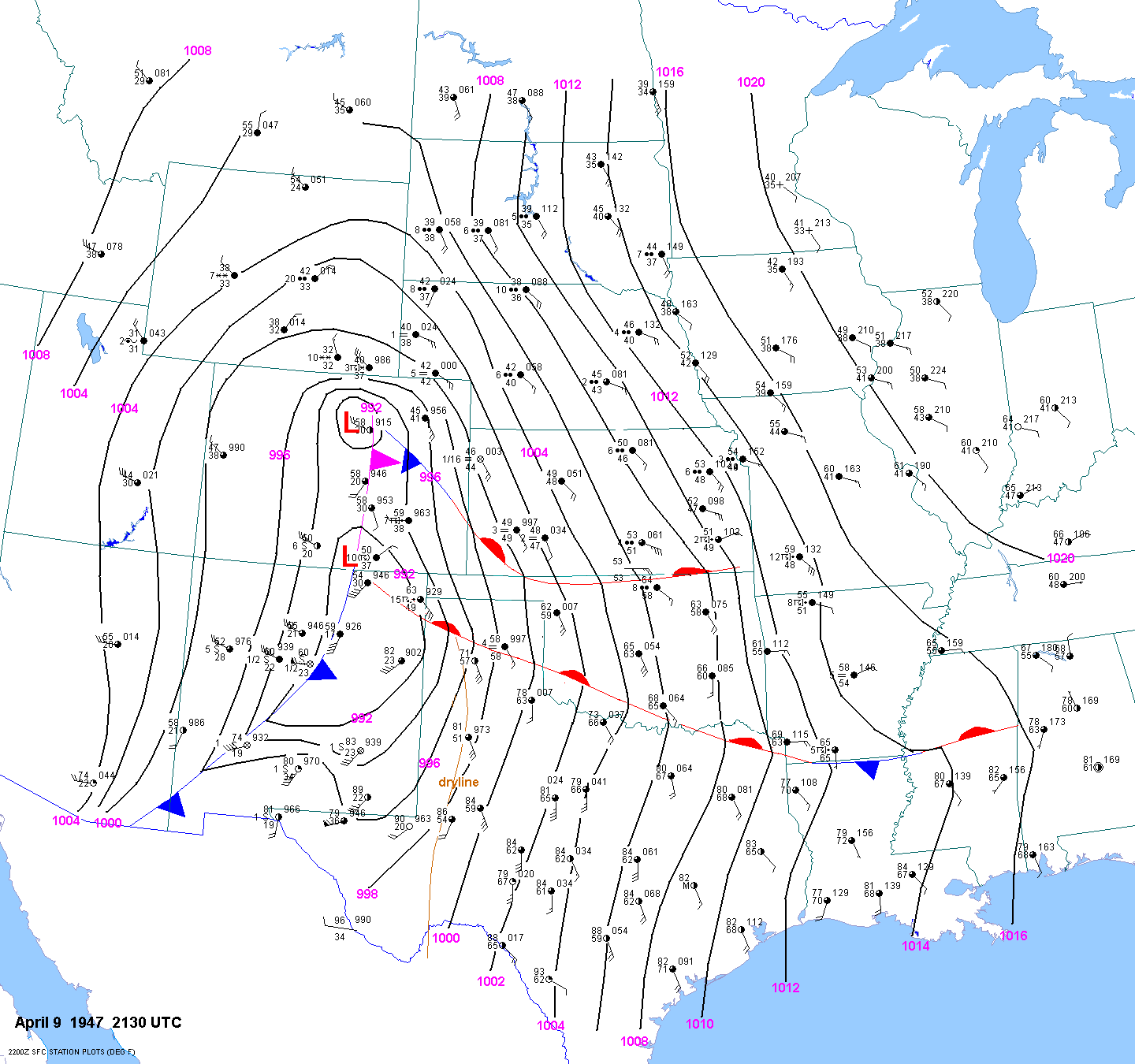
By 0030
UTC, surface low pressure was located over far NE NM and the OK
panhandle. The pacific cold front stretched
SSW then SW from the low to west of El Paso. The
occlusion extended north
into eastern CO. The warm front extended
SE then ESE from the low to N of Pampa and across
southern OK.
By 0330
UTC the surface low was not far from Guymon, OK, with the cold
front trailing to just east of Amarillo and into
SE NM. Frontogenesis was occurring NE of the surface
low into central
and NE KS. A cold front extended SW from the
occluded low near Limon, CO.