April 17 1970 Tornado Outbreak
Back to Lubbock Area Tornadoes Webpage
Back to Amarillo Area Tornadoes WebpageBack to Albuquerque Area Tornadoes Webpage
Severe Weather Events and Timeline
A
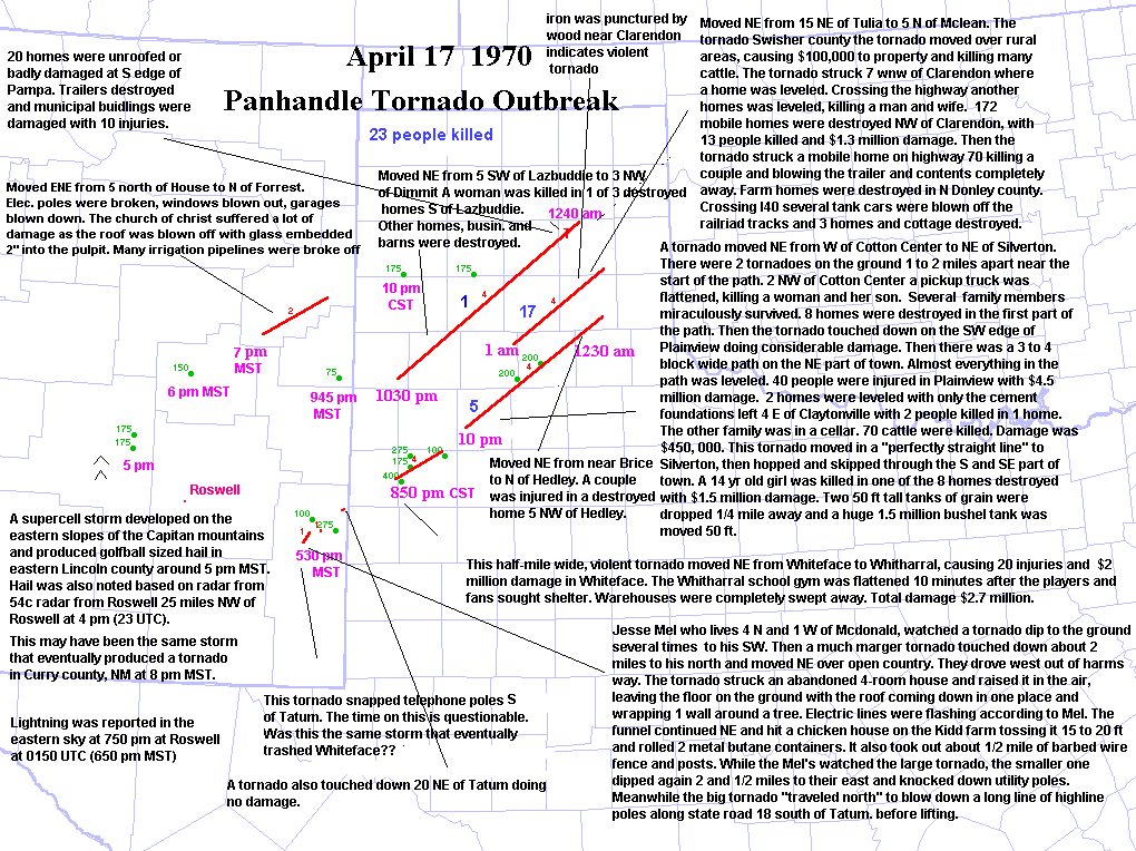
deadly tornado
outbreak occurred on April 17, 1970 across west Texas and the Texas
panhandle between 845 pm
and 2 am CST, with 23 people
killed. These tornadoes occurred at night and perhaps in the fog.
Storms developed on the
dryline in the foothills
between 4 pm and 5 pm MST from northwest of Roswell, NM
to to w/nw of Carlsbad, NM. Violent
tornadoes occurred as these
storms crossed a warm front in west Texas.
As I
studied this event I was very surprised at the lack of severe weather reports in
New Mexico just prior to the Texas
tornadoes. As one can see from the severe reports page, there were a few large
hail reports and tornado reports, but I
would have expected many reports given the synoptic situation. Keep in mind that
much of eastern New Mexico is
extremely rural, with only a few widely spaced little towns. So it is possible
that other tornadoes occurred that did no
damage and hence were not documented.
The storms that wreaked havoc across west
Texas and the Texas panhandle during the evening and overnight developed
along the dryline which was situated out ahead
of a pacific cold front. The low level winds were so backed on this day
that
the moisture was wedged up
against the higher terrain west of Carlsbad and Roswell. Storms
developed around Carlsbad
and northwest of Roswell in
the afternoon.
Three quarter inch hail occurred northeast of Las Vegas at 2330 UTC. Golfball
sized hail was reported at 00 UTC
about 25 miles northwest of Roswell, New Mexico, which is just northeast of the
Capitan mountains. Apparently this
storm developed on the lee slopes of the Capitan mountains. This storm
eventually became tornadic with mainly minor
F1
or F2 damage in Curry county NM. Prior to becoming tornadic, the storm
apparently produced 1.5 inch hail
in
DeBaca county.
Other storms developed further south and a tornado occurred in northern Lea
county at 0030 UTC. A man living in
McDonald, NM(south of Tatum)
observed 2 tornadoes(one of which was large). Before this
report, there were no prior
reports of severe weather with
this storm. But note that the area between Artesia and northern Lea
county is mostly open
country. Baseball sized hail and
1 inch hail were reported near the time of the tornado. The only other
severe weather report
of the day occurred near Clovis at 0445 UTC.
The
first severe weather report in the Texas panhandle was a violent tornado at
Whiteface at 0249 UTC, along with
4
inch hail. This storm moved northeast at 35 mph, producing several violent
tornadoes through 0710 UTC and killing
17
people. If the time of the tornado south and southwest of Tatum, NM is correct(530 pm MST), then this was clearly not
the same storm that went on to
destroy Whiteface, TX. I believe that this was the same storm and I
believe that the time
given in storm data is off by 1
hour. Is it pure coincidence that the Lea county, NM tornado
lines up perfectly with the
path of the tornadic storms to
the NE if one extends this path back to the southwest? Probably not.
Also, a time of
630 pm MST for the Lea county
storm would yield a storm motion of 35 mph which is the same speed at
which the
tornado moved across west Texas.
Thus, it appears that the storm that eventually trashed Whiteface and
Whitarral, TX
developed west-northwest of
Carlsbad or southwest of Artesia in the foothills in far western
Eddy county around 430 pm
MST. Indeed, the remarks in the
surface observations from Carlsbad at 5 pm indicate CBs to the north
and west. Also,
the area southwest of Whiteface
is wide open country. I suspect there was a family of several tornadoes
from southwest
of Tatum, NM to Whiteface to
Plainview, TX and on to Silverton, TX as well as Brice and Hedley.
The tornadoes
apparently became violent
upon crossing the warm front around Whiteface.
At
0330 UTC, a tornado was reported 5 miles SW of Lazbuddie. This tornado killed 1
person as it moved northeast to
3
miles northwest of Dimmit. There was a long break with no tornado reports from
this storm. At 1230 am a tornado
did
damage at the southern edge of Pampa.
At
0700 UTC a tornado was reported in Swisher county or about 15 miles northeast of
Tulia. This violent tornado or
family of tornadoes continued through about 09 UTC. This storm move over very
rural areas around the Paloduro Canyon,
between 07 and 08 UTC. Then after 08 UTC the tornado hit Clarendon and
killed 17 people. A piece of wood was
driven through iron pipe near Clarendon. It is unclear when this storm initiated and where. This storm may have not
developed along the dryline.
Perhaps this storm developed later in the evening when the cold front
was overtaking the
dryline.
Weather Situation
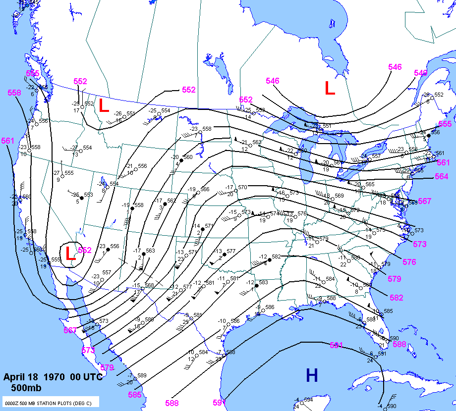
The
12 UTC 500mb chart showed very high 500mb heights(594 dm) in the Gulf of Mexico.
One shortwave trough was
located over the Great Lakes area. There was also a shortwave trough over the
deep south with a strong associated
500mb jet. A deep trough was noted over the desert southwest with a center over
California. There was strong
southwest flow across the southern Rockies. 500mb temps across west Texas and
the panhandle ranged from -12C
to
-14C.
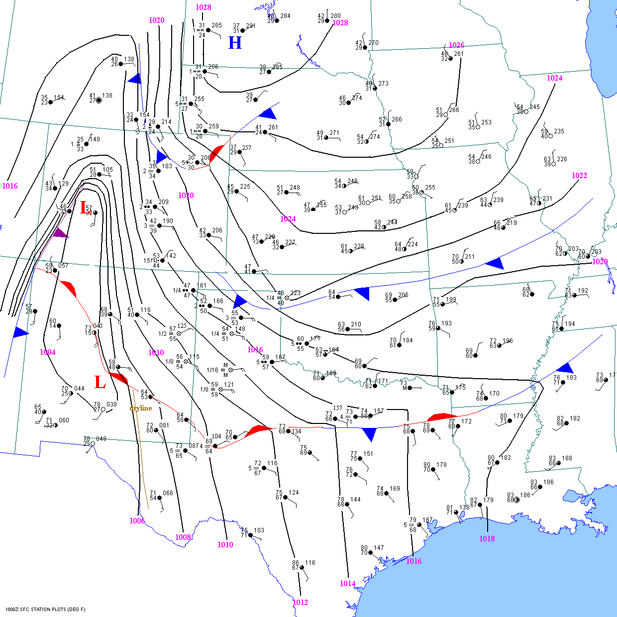
At
18
UTC, a surface front extended from eastward from Albuquerque to near
Midland and east across north Texas and
into
Mississippi. Upslope flow north of the front across west Texas resulted in dense
fog from Amarillo to Clovis to Lubbock.
Rich
gulf moisture was present south of the front as far west as Midland and Wink.
But there was no lack of moisture north of
the
front, with 59F dewpoint well north of the front at Lubbock.
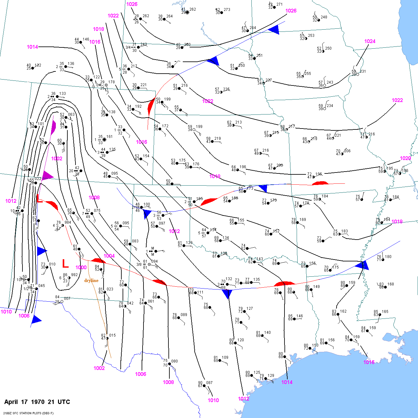
At
21
UTC the surface front was slowly lifting north and extended from north
of Abq. to north of Roswell to south of
Lubbock. Dewpoints were very high for April with lower 60sF dewpoints into
southeast New Mexico. North of the
front at Lubbock the T/Td were 61F/61F with fog. Another front stretched
from the northern TX panhandle across
northern Oklahoma. Between the 2 fronts, gulf moisture was adundant with
low-level upslope flow. The surface dryline
was
located west of Roswell and Carlsbad. A pacific cold front was located
across western NM.
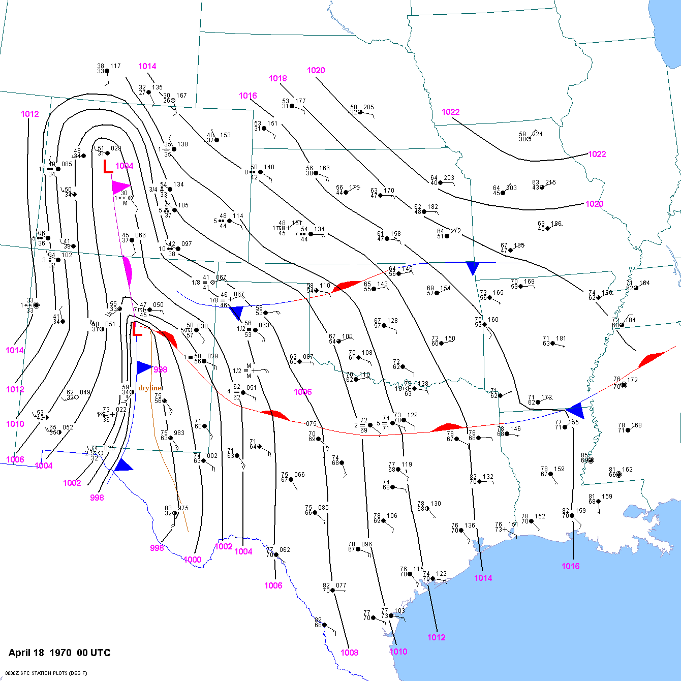
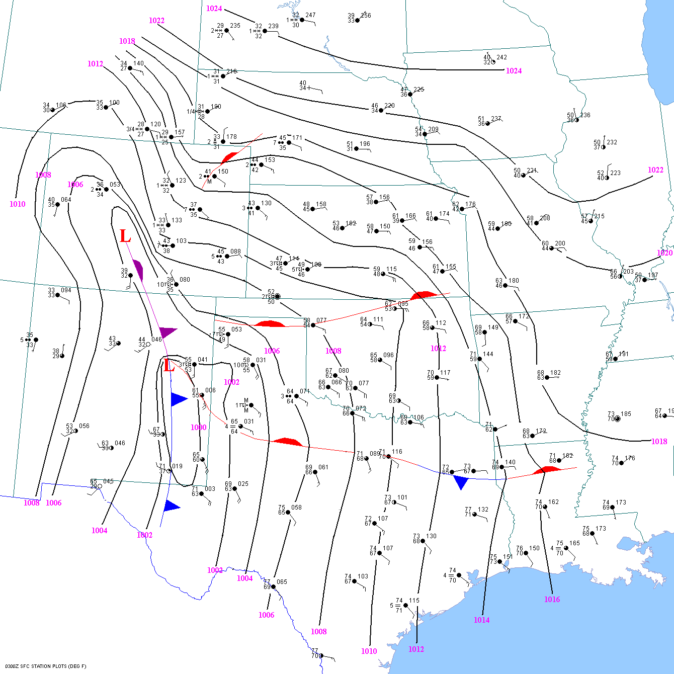
At
00
UTC the southernmost front extended from southwest of Clovis to
south of Lubbock to south of Mineral Wells.
The
surface dryline was located on the immediate front range, or west of Roswell and
Carsbad. The pacific cold front
was
oriented north-south had passed El Paso and Alamogordo, NM. The T/TD at Reese
AFB(Lubbock) was up to 62F/62F
but
the visibility had increased to 4 miles. Lubbock was still north of the warm
front.
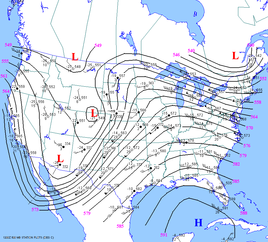
The
00
UTC 500mb chart showed a shortwave trough beginning to eject northeast
from southern NM. 500mb temps
across the Texas panhandle still ranged from -12 to 14C, with 65-75 kt 50mb
winds.The 500mb temp. at El Paso had
dropped to -15C from -13C.
At
03
UTC, the surface warm front stretched from near Clovis to just south of
Lubbock to near Fort Worth. The T/Td at
Reese AFB(the closest observation to the initial tornadic storm) was up to
65F/64F(station pressure 885mb). Using a
500mb temperature of -13C gives a -9 lifted index at Reese at 03 UTC. So surface
based instability was high even north
of
the warm front with a "cool" temperature of 65F. But keep in mind that the
actual surface temperature is meaningless
without considering elevation. It is the potential temperature that is
important. For example, a surface temerature of 65F
at
Reese has the same potential temperature as a temperature of 84F at 1000mb. And
a 64F dewpoint at Reese a mixing
ratio of 14.6 g/kg, which has the same moisture as a 67F dewpoint at 1000mb. So
65F/64F at Reese has the same
T/Td
as 84F/67F along the Texas coast. So be very careful when assessing the
"coolness" of an airmass. As mentioned
previously, the first tornado occurred about 35 miles west-northwest of Lubbock
or about 25 miles west northwest
of
Reese at 0249 UTC. So I feel that the conditions at Reese at 0255 UTC were
representative of the inflow into the storm.
I
also feel that the storm produced a violent tornado upon intersecting the warm
front. The warm front slowly progressed
north throughout the night, so the tornadic storms remained along or north of
the warm front all evening. The is some question
as
to whether the last violent tornado at 07 UTC was north or south of the front.
This will be addressed as soon as I can
finish the 05 UTC and 07 UTC surface maps. I suspect that the latter tornadoes
all occurred in the warm sector south of
the warm front. It
looks as though the warm front underwent rapid frontolysis during the late
evening. But I am fairly
confident that the first violent tornadoes
in near Whiteface and Whittaral occurred immediately north of the warm front.
At
12
UTC the 500mb chart showed that the aforementioned shortwave trough had
ejected rapidly NNE into the central
plains.
It is widely accepted that the tornadoes
occurred in dense fog. While dense fog may have occurred out ahead of the
storms
or well ahead of the warm front, the observations at Reese
AFB indicate that the visibility increased to 4 miles as the
tornado
was passing to the west-northwest of the station.