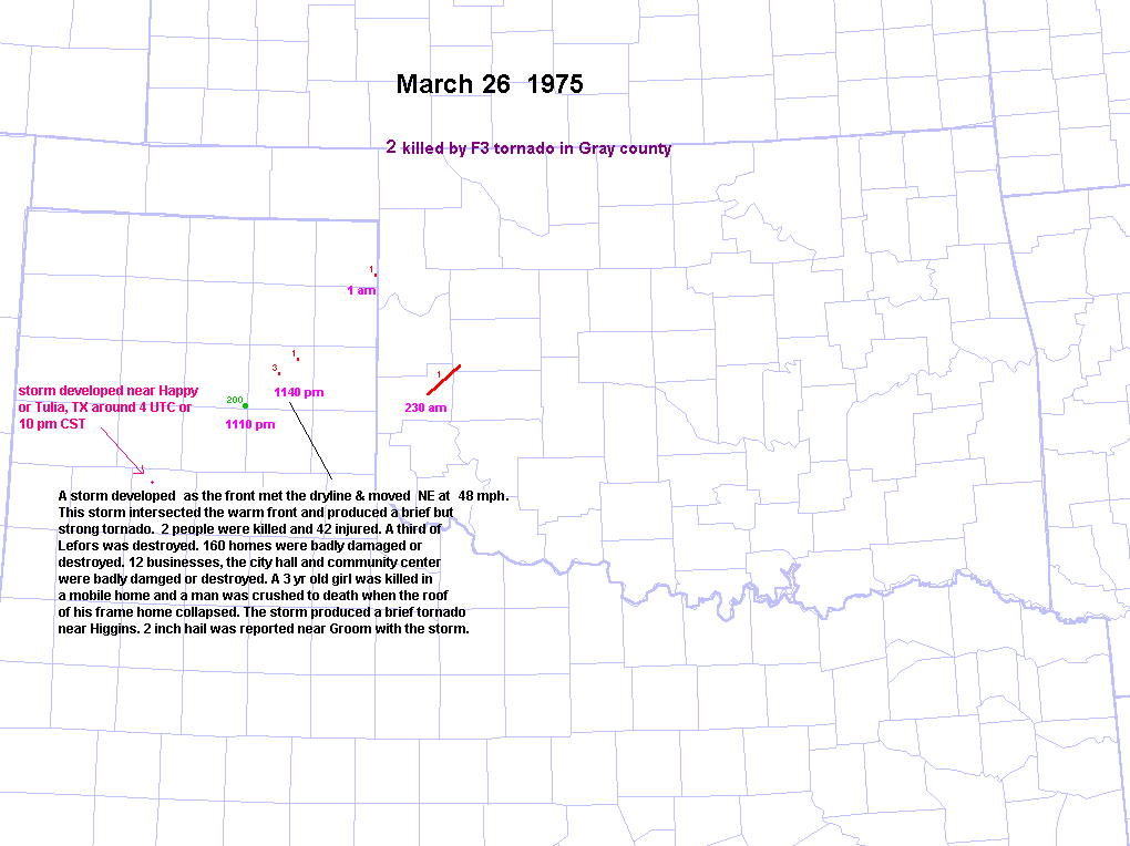
March 26 1975 Lefors, TX Tornado
Back to Amarillo Area Tornadoes Webpage
Brief Overview
A strong
tornado hit Lefors, TX around 1140 pm CST on March 26, 1975. About 1/3 of the town of Lefors was destroyed and 2
people were
killed. Two-inch hail occurred in Groom, TX(24 mi. SW of Lefors) around
1110 pm from apparently the same storm.
Sequence of
events
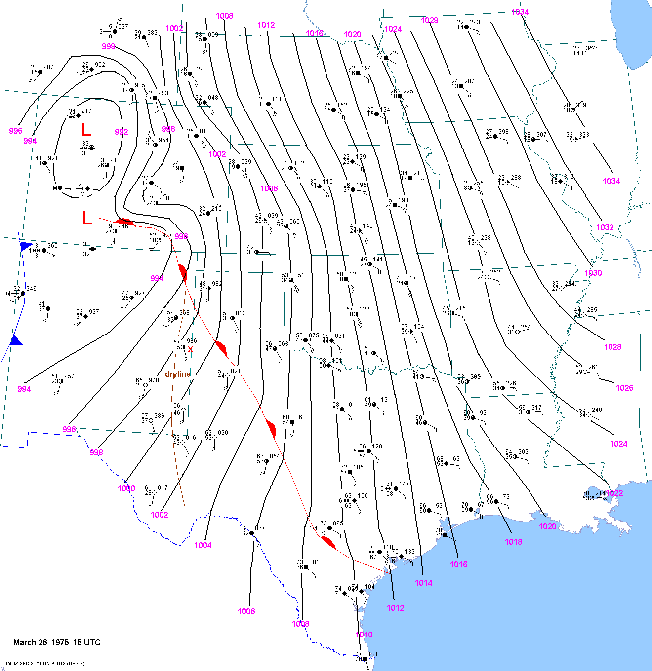
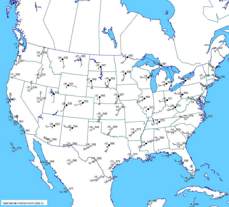
The 12 UTC
March 26 500mb chart showed a deep trough over the southwest US with
strong flow across the plains states.
At 15
UTC, a 991 mb surface low was located over western Colorado with another
low over northern, NM. A warm front stretched
from south
Texas northwestward to south of Amarillo to southern Colorado.
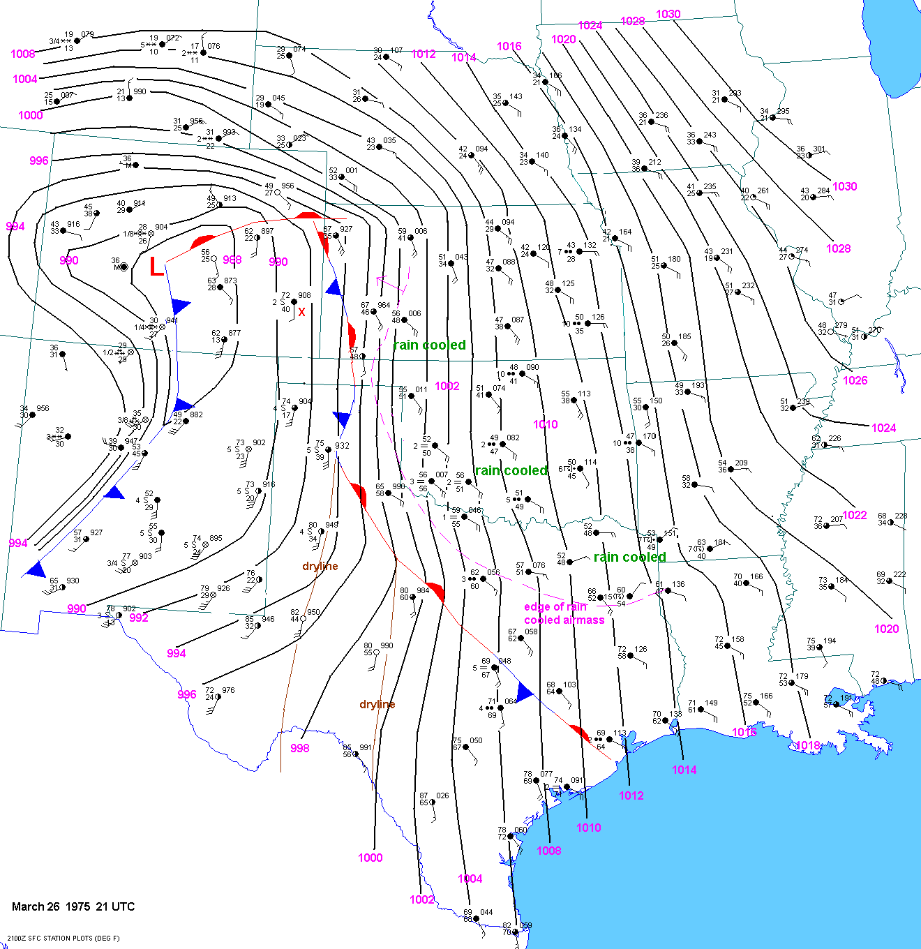
At 21
UTC
a strong "pacific" cold front was moving east into central NM. A 986mb
surface low was located over central Colorado.
Two drylines
were apparent. The westernmost dryline stretched from near east of
Amarillo to east of Lubbock to near Midland.
But the
really rich low level moisture was quite a bit further east and confined to
the east of a line from east of Del
Rio to near Abilene.
A front that
was mainly stationary or moving very slowly northward stretched from
south of Houston to north of Abilene to east of
Amarillo, then
north into western Kansas. However, persistent rain into a dry, cool
airmass had resulted in a cooler airmass over far
northern Texas
into much of Oklahoma and Kansas. The leading edge of this airmass
was charging westward through western Kansas.
I chose
not to label this boundary as a front but as a dashed pink line.
By 00
UTC the warm/stationary front stretched from near Houston to just south
of Waco to southwest of Childress. The cold
front
was still
charging east into eastern NM. A surface low was over central CO with
another low along the front in New Mexico.
The
00 UTC
500mb showed a longwave trough over the western US. Shortwave
troughs were rotating around the main trough
and one of
these was approaching the southern plains. 500mb temps were
very cool--around -18C in the Texas panhandle. There was
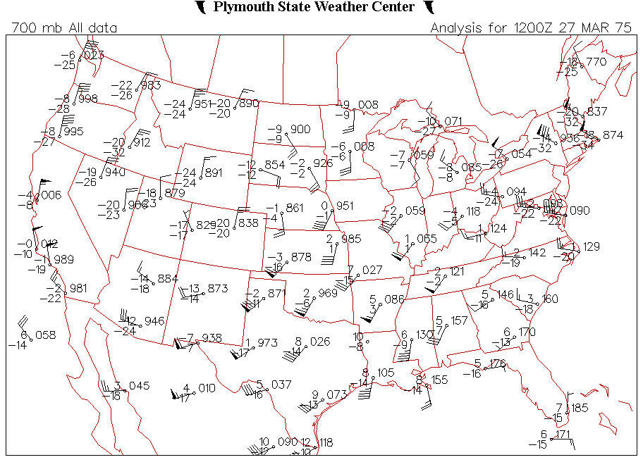
a 110kt 250mb jet streak across the TX panhandle. The 700mb winds were on the increase and up to 45 kts across the panhandles.
The
02
UTC surface chart showed a the pacific cold front charging east
into the western Texas panhandle. Two drylines were still
evident with
the western most one located west of midland and barely east of
Lubbock. A warm front stretched from south of Childress to
south of Waco.
A rain cooled airmass still persisted further north and the boundary
associated with this airmass was located over far
north Texas.
An arctic front was barreling down the front range of Colorado.
Note the lower 60sF dewpoints north of the warm front
advecting back
to the NW through Childress. The 02 UTC ob from Amarillo showed
south winds at 35kts with gusts to 50kts. Thus the
850mb winds
had increased at least to 50 kts at Amarillo between 00z and
02z. Undoubtedly a strong low level jet was in place across
the central
and eastern panhandle region.
At 03
UTC the pacific cold front was just west of Amarillo and about to
overtake the dryline. The cold front actually overtook the dryline
between
Amarillo and Lubbock around 4 UTC--perhaps in western Swisher county.
The offending storm apparently developed in this
location
around 4 UTC and moved rapidly NE. The movement of the front(to the east at
30 mph) allowed the storm(moving
northeast at
~ 50 mph) to
stay very near or just ahead of the front. The 05 UTC surface map
can be found here.
Note that the warm front had
progressed
through Childress. By 0540 UTC, the cold front was located very
close to Lefors, which also corresponds to the time of a
strong
tornado. Also note that the warm front was located just
southwest of Lefors at 5 GMT. Thus, it appears that the storm developed
near the
location where the cold front was overtaking the dryline
between Tulia and Happy, then moved rapidly NE and encountered the
intersection
of the cold front and warm front near Groom around 5 GMT. The
winds immediately north of this front were very backed and
dewpoint
depressions were near zero. T/TD values were probably around 61F/60F at
887mb based on the obs at Childress and adjusted
for elevation. I
adjusted for elevation since in a upslope regime, temps on the higher
terrain will usually be a little cooler at night with no insolation.
The elevation of
Childress is only 1800ft while Lefors is about 3000ft. Using
700/500/400/300/250/200mb temps. of 3/-18/-30/-44/
-52/-60C yields a surface based CAPE of from 2500 to 3000 j/kg and
lifted index from -10 to -13!!! It would be nice to have upper air charts
from 06 UTC.
It is very hard to fathom this much instability in the Texas
Panhandle around midnight in March!! But it certainly appears that this
was indeed the
case. It would also be nice to have a few more surface observations in
the region of interest. Any conservative estimate would
probably be
greater than 2200j/kg CAPE and LI of lower than -9. Who knows what
the mean layer CAPE would be in this instance. There is no
way
to approximate this with the data given. But there is no reason to
believe that the mixing ratio dropped off significantly with
height along and
north of
a warm front. Surface based CAPES were around ZERO in western OK.
This storm did not produce any more significant tornadoes
after
the Lefors tornado. Apparently the storm crossed the northern boundary and
encountered very stable cold air over the eastern Texas
Panhandle.
The positions of the boundaries at varying times and
location of the tornado and large hail are shown here.
I suspect that the Lefors
tornado did
not touch down in Lefors and lift immediately
after leaving Lefors. But there were probably no
structures to hit ne and sw of Lefors.
The 12 UTC
500mb chart can be found here. The 700mb winds were 65 to 80kts by 12z. The wind profile around 06 was probably similar to
the following:
surface 12025kt
850mb 18060kt
700mb 21060kt
500mb 22070kt
250mb 21110kt