March 28 1984 Carolinas Tornado Outbreak
under construction
last modified January 26 2009 0519 GMT
Jonathan Finch
National Weather Service
Dodge City, KS
(Jonathan's personal website)
best viewed in 1024 X 768 resolution
submit photos or storm stories from March 28, 1984 ------> hugehail@yahoo.com
"Google Maps" was utilized to
create paths of the tornadoes. All the tornadoes were plotted in
"Google Maps" and then iindividual tornadoes were plotted using screen
captures of "Google Maps" amd then annotated.
Introduction
This
web page (currently in its infancy) will be devoted to the infamous tornado outbreak of March 28,
1984. In addition to a detailed independently established time line,
damage pictures, google earth damage paths, radar imagery, personal
accounts, newspaper accounts...etc, a detailed meteorological study is
also presented including satellite loops, detailed surface map loops,
accurate upper air charts, sounding and wind shear approximations and
much more.
On March 28, 1984 at 1:50 pm
EST, a thunderstorm developed in Randolph
county in eastern Alabama, or about 60 miles west-southwest of Atlanta.
This parent thunderstorm, despite taking on different sizes, shapes and
dimensions, was the same convective system that weakened around
10:30 pm along the eastern seaboard after killing 36 people in
North Carolina and 13 people in South Carolina. This storm became
a tornado producer between Athens and Atlanta and a prolific tornado producer around 5
pm in western SC, and continued producing tornadoes one after another
through eastern North Carolina until 10:30 pm. The last person claimed
by this storm was in Perquimans county, NC--southwest of Elizabeth
City. Very large hail occurred with the storm, including
tennis ball sized hail south of Elberton, GA and baseball
size in northern SC. Large hail also occurred in North Carolina but the
focus was on the tornadoes and not on documenting hail. It is very rare
indeed for a parent storm to survive over 8 hours
and 550 miles. The average forward speed of the convective system from
birth to death was an amazing 65 mph!! This is one reason why people
had little time to escape the storm. A storm motion of 65 mph is
definitely on the extreme high end of possible storm motions for
violent tornadic storms. Storms in the southeast United States tend to
occur in the cool season when the jet stream is strong--hence the swift
storm motions. Tornadic storms in the Great Plains of the United States
tend to move slower and occur later in the spring on average. Another
storm developed between Laurinburg and Fayetteville and produced very large hail in
southern and central NC (golfball to baseball size) before becoming
tornadic around Rocky Mount.
This storm was situated north-northeast of the main event and
produced a series of strong
tornadoes in northeastern North Carolina and extreme southeastern Virginia, killing 9 people.
I am developing detailed paths
of the tornadoes and hail occurrences in Google Maps. I also plan to
use Google Earth since Google maps had limited icons and features. To
accomplish this, I used the
original storm data and newspaper accounts as well as the old NWS
assessment. However, I also made phone
calls to the affected areas and refined the paths. People that were in
the path of this monster storm tend to remember it. I called a man that
was mentioned in a newspaper article from Elberton, GA. His wife
answered the phone and said her husband was deceased. However, as soon
as I mentioned a storm in 1984, she instantly told me that she would
never forget that storm. She told me that she remembered the tennis
ball sized hail and apparent tornado damage. Also, the official times
given for several of the tornadoes were not accurate. I was able to
find clock stoppage times at several locations to help pinpoint the
time line. Then I was able to calculate the speed of the tornadic storm.
To view storm details, just use the +/- bar on the left side of google
maps, then click on the blue pushpins to see the details.
How many tornadoes occurred on
March 28, 1984? Does it really matter? It is unwise to get
fixated on the number of tornadoes that
occur in a given outbreak. It is the intensity, path length, and path
width or tornadoes that are important. For example, a single tornado
that is
1/2 mile wide and on the ground doing F4 damage for 50 miles is far
more capable of being lethal than a family of 20 tornadoes (mostly
rated F0, F1 or F2 with perhaps 1 brief F4) that skip (not continuously
on the ground) across the
same 50 mile stretch. So whether there were 5, 10, 20 or 30 tornadoes
means very little to me. What is a "tornado outbreak"? How many
tornadoes constitute a tornado outbreak? How many tornadic storms
constitute an outbreak? Does there have to be a certain number of
tornadoes in an event for the event to be classified as a tornado
outbreak? If a storm produces a 1/2 mile wide F4 tornado with a path
length of 100 miles and another storm produces 20 tornadoes (1 F4 and
19 F1's) over this same 100 mile path, which event would be classified
as a tornado outbreak? Perhaps the intensity of an event has little to
do with whether the event is technically an outbreak. You can be sure
that the news media would have a field day explaining that 20 tornadoes
occurred as if the number really mattered.
Satellite Loops
Satellite loops were created using images from the CLASS website. Dan
Bikos of CIRA (Cooperative Institute for Research of the Atmosphere) in
Fort Collins, CO provided help in capturing these images. I made this
loops using the "convert" command in AWIPS. The visible loop shows the progression of the primary storm cluster from birth to just before dark. The infrared loops show the entire life cycle of the storms.
Radar Data/Loops
Two radar loops from the Wilmington, NC radar were created using radar
data on microfilm provided by NCDC. To accomplish this, I visited the
local public library in Dodge City, KS and displayed the radar data on
a microfilm reader. Then I took digital still pictures of each image
from 2347 UTC until 0144 UTC. The images were available every minute.
However, I only used about 25% of the images due to concerns
about download time. Also, the program I used to create the loops do
not support 100+ frame loops. I had to change microfilm rolls at a
very inopportune time. There was a 35 minute gap in the radar data
from the 1st roll to the 2nd. So I made a 2nd shorter loop starting at
0223 UTC. The first loop shows the storm moving from Cash, SC to just southwest of La Grange, NC. The 2nd loop shows the storm moving from just southwest of Pactolus, NC to northeast of Pactolus.
Meteorological Discussion
New!! Animated 1-hourly surface charts from 15 to 05 UTC
slow medium fast
Synoptic Overview
On
March 27 to March 28 1984, a very intense and progressive shortwave
trough and associated jet streak migrated from the southern Rockies
into the southeast United States to the eastern seaboard. The
circulation around the surface cyclone covered the eastern 1/2 or 2/3
of the continental United States. A sub-synoptic surface low pressure center raced east-northeast across
the deep south and into the southern Mid-Atlantic region during the
afternoon and evening of the 28th. The flow at all levels was very
strong, leading to very fast storm motion. A thunderstorm developed in
eastern Alabama near the surface low around 1:50 pm. The primary
supercell storm stayed immediately ahead of the sub-synoptic low and
raced east-northeast at 65 mph through 10:30 pm. Loops of the 500mb and 300mb charts demonstrate how this system progressed across the country.
March 26
On the evening of March 26, a large upper trough was centered over the high plains and eastern Rockies. A very strong 500 mb
jet was positioned along the back side of the trough, indicating the
trough was still digging. This is even more evident on the 300 mb
chart that showed 120-140+ kt jet winds from the pacific northwest into
western NV. A surface front extended from just south of Tampa, Florida
to the Texas Gulf coast. Dewpoints along and south of this boundary
were near 70F as evidenced by the observations at Brownsville and
Miami. So rich moisture was only a few hundred miles away from north
GA. Sea level pressures were down to around 996 mb in the lee of
the southern and central Rockies.
March 27
By 12 UTC March 27, a strong shortwave trough was located over the southern Rockies with 110 kt 500 mb winds at Las Vegas and 100 kt winds at Tuscon and El Paso. The upper trough still had a slight positive tilt. 300 mb
windspeeds near the core of the jet were around 120 to 125 kts at Ely
and Tonopah, NV. Jet winds were also fairly strong from central and
south TX into the Carolinas (90 to 110kts). Rich moisture from the Gulf of Mexico was
advancing northward to the Gulf Coast. The surface dewpoints at
Boothville in southeast Louisiana and Tampa, FL were up to 68F and 71F
respectively.
By the afternoon of March 27, a neutrally tilted 500 mb
trough was located over West Texas. 500 mb winds were not sampled very
well in central TX, but were likely around 100kts. The 300 mb jet core now extended from El Paso to southern MS, with 120 to 140kt winds. 700 mb winds were 50kts or greater from the Texas Big Bend to southern GA. The 21 UTC
surface chart (to be completed) shows rich moisture from the panhandle
of Florida to central LA and southern MS to the south of a warm front,
with dewpoints in the mid to upper 60s F. Surface pressures were down
to around 988 mb in north TX. A surface dryline extended from just east
of Brownsville, TX northward along the Gulf Coast. In fact, the
temperature at Brownsville was a staggering 106F with a dewpoint of
42F!! Severe storms
including very large hail and tornadoes occurred during the afternoon
in north Texas, with the most severe storm occurring
northwest, north and northeast of the Dallas-Fort Worth Metroplex. This
severe weather occurred outside of the classic warm sector (north of
the surface low), where colder 500mb temperatures existed and where
58-60F surface dewpoints resided.
Evening of March 27
A warm front slowly pushed north from north Florida into southern Georgia during the evening hours. At 03 UTC
the front stretched from south of Jacksonville, FL to just north of
Dothan, AL. The stationary part of the front continued northwestward to
near Greenwood, MS. An outflow boundary from storms was progressing
southeastward through far western MS and northern LA. Surface
dewpoints were generally between 67 and 70F south of the front. A cold
front was moving through eastern TX with another stronger cold front
moving through the DFW area.
At 06 UTC
the eastern end of a warm front extended from north of Jacksonville to
just south of Valdosta to just north of Tuscaloosa, AL. An outflow
boundary continued to move through Mississippi. The two cold fronts
continued to move across TX and LA.
Early Morning of March 28
By 09 UTC
March 28, the eastern end of the front in the deep south was still
progressing northeastward and stretched from the GA coast to near La
Grange, GA. The outflow boundary was progressing southeast through
Alabama. The first of 2 cold fronts had passed through New Orleans. The
2nd cold front stretched across central and western LA.
12 UTC March 28
The
12 upper air charts showed an extremely intense shortwave trough
progressing rapidly across the southern United States. The center of
the trough was over northeast Arkansas. 500 mb
winds were 80 to 90 kts across the deep south. The sounding at Athens,
GA was apparently contaminated by convection. A band of 60+kt 700 mb
winds extended from east TX into southern MS and AL. The 850mb chart
showed 50-60 kt flow at 850mb from the southwest with 11 to 13C
dewpoints.
Mid to local noon March 28
An
outflow boundary caused by early morning convection was starting to
retreat northward in Alabama but was still stationary over Georgia.. I
decided to draw this in an a warm front since its horizontal dimensions
were now on the synoptic scale. At 15 UTC
the boundary stretched from southern Alabama into central Georgia. I
also decided to draw this boundary continuous with the previous warm
front that surged into the Carolinas overnight. While high surface
dewpoints existed from Alabama eastward to the eastern seaboard, the
highest dewpoints (68 to 72F) were located further east from eastern SC
into eastern GA and Florida. By 17 UTC,
the warm front has progressed north of Montgomery, AL and Columbus, GA.
A cluster of thunderstorms was about to initiate near Augusta
around 17 UTC near the weak surface front.
18-20 UTC (1-3 pm EST)
A deep surface low pressure system developed between 18 and 20 UTC.
The central pressure of the low dropped from about 985 mb to about 978
mb. Prior to this rapid deepening, the surface low embedded in the
much larger scale low was much less progressive. However, a deepening
and acceleration of the low occurred simultaneously. Between 18 and 19
UTC the surface low moved from central Alabama to far eastern Alabama
and deepened from 985 to 982 mb. Between 19
and 20 UTC the low progressed from eastern Alabama to just east of
Atlanta and deepened from 982 to 978 mb. The low developed inside of a
much larger scale, surface low pressure system that spanned much of the
eastern United States. The aforementioned storm cluster that developed
near Augusta at 17 UTC continued to the east-northeast and reinforced
the weak frontal boundary across South Carolina. The storm cluster
responsible for much of the severe weather on March 28 developed in far
eastern AL at 1950 UTC (1:50 pm EST) immediately ahead of the surface
low. There were reports of 1 inch hail in the Atlanta metro area around
3 pm EST with the passage of the surface low. The severe weather
occurred immediately ahead of the low along the warm front where the
vertical wind shear was maximized. Surface based CAPE values across
north GA were around 2000 j/kg.
21-22 UTC (4-5 pm EST)
By 21 UTC
the center of the surface low was just east of Athens, GA with a
central pressure of about 976 mb. The surface warm front or retreating
outflow boundary was about to move northward through Columbia, SC. The
T/TD at Augusta, GA were 83F/65F with strong south winds at 20 kts.
Surface based CAPE values were approaching 3000 j/kg ahead of the
surface low. Located just north of the front, the T/TD at Columbia were
74F/65F with light east winds. So surface based CAPE values immediately
north of the front were about 2000 j/kg. Severe storms intensified
after passing east of the Atlanta metro area. Hail as large as tennis
balls and several tornadoes caused extensive damage in central and east
Georgia. The first of a several member family of strong to violent
tornadoes touched down west of Newberry around 5:06 pm. Golfball to
baseball sized hail accompanied the storm in Newberry.
23-00 UTC (6-7 pm EST)
The surface low continued to
race east-northeast at 65 mph through 00 UTC (7 pm EST) when the tornadic
storm was near Bennettsville, SC. The surface based CAPE
in Florence at 6 and 7 pm EST was about 3200 j/kg. Thus the
combination of shear and CAPE was on the high end of what
typically occurs in the Carolinas. Interestingly,
surface based CAPE values were higher further east in North Carolina
and dewpoint depressions were lower. At 23 and 00 UTC the T and Td were
73F/70F at Florence, SC. This may help explain why the tornadoes in
northeast SC and southeast NC were more violent than the ones in
western SC.
00 UTC March 29 (7 pm EST)
The
00 UTC upper air charts featured an exceedingly deep but progressive
shortwave trough and associated jet streak over the deep south and
southeastern United States. The sounding from Greensboro was
unfortunately contaminated by convection. The 00 UTC sounding from
Athens, GA (probably launched just after 23 UTC) was taken about 2.5
hours after the storm cluster and associated sub-synoptic low pressure
system passed. The 500 mb
chart was particularly impressive, showing 104 kt winds at
Apalachicola, 102 kts at New Orleans and 102 kts at Athens, and 96 kts
at Charleston. The sounding at Waycross, GA was missing at high levels,
but 102 kts was reported at 558 mb. The 500 mb winds over the tornadic
storm in northern SC were probably about 90 to 100 kts. The 700 mb
chart was also impressive. The 700 mb winds were 72 kts at Waycross, 90
kts at Apalachicola, 60 kts at Athens, 71 kts at New Orleans and 54 kts
at Charleston. It is difficult to tell how strong the winds were in the
vicinity of the primary tornadic storm in northern SC. But given the
64+ mph storm motion, it is likely that 700 mb windspeeds were 60 kts
or greater. It is also difficult to tell how strong the 300 mb winds
were. But this 300 mb
chart indicated windspeeds near or greater than 100 kts. The NARR
reanalysis data for 00 UTC March 29 did a poor job at recreating the
mid to high level windspeeds across northern SC, underestimating the
700 to 500 mb winds by 20 to 35%. This is probably due to smoothing
techniques. The core of the jet was able be to recreated fairly well,
but the northern part of the jet core was smoothed far too much. As a
result, the 700-500 mb windspeeds in the reanalysis were far too weak
to support a storm speed of 64 mph. Hence, I did not include any
reanalysis charts.
The 01 UTC
surface chart continued to show surface dewpoints from 68 to 70F
in the warm sector across the eastern sections of North Carolina and
South Carolina. The center of the surface low was located just
southeast of Fayetteville. By 02 UTC and 03 UTC,
the center of the low was southwest of Greenville, NC and southwest of
Edenton, NC respectively. By 03 UTC the sub-synoptic low had begun to
pull ahead of the synoptic scale cold front to the northeast.
Georgia Severe Weather (220 pm to 420 pm)
Map of possible Tornado Events in Georgia (using google maps)
After storm initiation in far eastern Alabama at 1:50 EST, the
first hints or actual reports of severe weather with the primary
convective system to eventually cause devastation across the Carolinas
occurred in the western Georgia and in the Atlanta Metropolitan area
just before 3 pm EST. A funnel cloud was observed near Douglasville, GA
at 2:20 pm and one-inch hail was reported by an Atlanta TV station in
Fulton county at 2:52 pm. One-inch hail was also reported in DeKalb
county at 2:58 pm. Wind damage was reported in far eastern Dekalb county
at Lithonia at 3:13 pm although this time is probably too late by 5 to
15 minutes. The roof of a business was heavily damaged. A car in an
adjacent parking lot was heavily damaged when part of the roof from the
building fell on it. An apartment building nearby also suffered roof
damage. This could have been a weak tornado. The time of this event was
probably earlier than reported.
Around 3:15 pm, a tornado touched down about 6 miles west-southwest of
Winder and moved east-northeast across Yargo State Park. Hundreds of
trees, 30 chicken houses, 1 mobile home, a golf course, and caused
minor roof damage to hundreds of buildings. A child in a mobile home
suffered minor injuries.
A tornado was sighted north of Statham, GA around 3:30 pm. No damage was reported with this tornado.
Around 3:45 pm, Civil Defense Director David Fitzpatrick reported that a
tornado (moving almost due east) touched down on Nowhere Rd near
Sanford and caused damage in a 15 mile long strip. He reported that the
tornado "left a wide, discernible trail of damaged buildings and trees
for 15 miles. 35 homes suffered moderate damage to heavy damage, with
windows broken, roofs partially ripped away and carports demolished".
Another 50 homes reported light damage. Two mobile homes were
destroyed, 6 were blown off their foundations and 35 suffered
miscellaneous damage according to Fitzpatrick. Six poultry houses were
destroyed and 17 suffered roof damage. 5 barns and utility houses were
blown down and 28 others had roof damage. Trees as large as 3 ft in
diameter were uprooted and tossed into buildings and across roadways.
This event is officially documented as straight line wind damage.
Around 3:57 pm, a probable tornado touched down near Point Peter in
Oglethorpe county and moved east-northeast to about 5 miles south of
Elberton. A brick building was destroyed in northern Oglethorpe County
north of Point Peter. Here is the text of a story by Glenn Weber that
appeared in the "Oglethorpe Echo".
Gary Darnell said he praised the Lord he wasn't more seriously injured.
The 24 year old man was with several others working in Onnie
Willingham's shop on the Dora Bush Hill Rd last Wednesday afternoon
when they heard a tornado watch was in effect for their area. Two or
three minutes later "it started to hailing and the wind got stronger,"
Darnell said. "Brick and steel got to flying everywhere." 'The cement
block walls of the shop began to topple under the force of the powerful
wind and the men inside rushed to escape. "We were trying to leave and
the wind just picked us up and blew us into the wall," Darnell recalls.
He and Willingham were trapped briefly under tin and other debris from
the collapsing building. This damage was officially caused by straight
line winds.
Elsewhere in the county, trees were downed and large hail was
propelled through windows of homes. Homes and outbuildings were damaged
in Beaverdam Estates. In the Sandy Cross area a trailer was damaged and
a chicken house was unroofed. In the Glade community, trees were
toppled and windows and siding of homes were pelted by hail. As this
storm progressed a little further east, a mobile home was overturned on
Jones Ferry Rd about 5 miles south-southwest of Elberton in Elbert
County. A tornado apparently occurred on Lexington Highway 4 miles
south of Elberton. Trees were uprooted and thrown on top of a car and a
house at the Marco Goodwin residence and tennis ball sized hail also
occurred. This information was gathered from a personal conversation
with Marco's wife. She still vividly remembered the storm after 25
years.
South/North Carolina Severe Weather (420 pm to 709 pm)
The severe thunderstorms in Georgia evolved into a short line of severe thunderstorms before entering South Carolina. Just
before the Due West (using Google Maps) tornado occurred, 10 mobile homes were overturned
and golfball sized hail was reported a few miles south of Anderson, SC.
Large hail and high winds continued to the east-northeast to just south
of Spartanburg. About 4:20 pm, a tornado developed along the line segment
south or southeast of Due West, SC. Two other tornadoes developed
northeast of this initial tornado affecting Ware Shoals and areas north
and west of Laurens. Several people suffered minor injuries. In
Abbeville county, 15 families had to be relocated because of damage to
their homes. There were 15 badly damaged homes in Abbeville County and 3
in Anderson County. Patricia and Henry Brownlee were thrown from their
mobile home and somehow received only minor injuries. The only thing
that remained of the mobile home was some of the flooring and wheels.
Next door, the two story brick home belonging to James and Brenda Byers
took a direct hit and was totally destroyed. The storm hit around 4:20
pm. The next tornado in this family developed near Ware Shoals.
The final tornado with this family apparently developed about 6 miles
west of Laurens. 500 acres of timber were downed and 18 mobile homes
were destroyed. Forty-three people were injured along this tornado path from
west of Laurens to northeast of Laurens.
Around 430 pm, a significant blowdown of trees occurred in
southern Abbeville County. The State Forestry Commission declared a
forest disaster for Abbeville County. Part of this blowdown was
in the Sumter National Forest. This information is not included in
Storm Data.
After causing major damage to timber in Abbeville County, the
"first" member of a 337 to 410 mile tornado family apparently touched
down about 9 miles west-southwest of Newberry
(using Google Maps) around 5:06 pm. Whether this was actually the first tornado in the
family is debatable since the blowdown of timber in Abbeville County,
and damage in Oglethorpe and Elbert Counties in Georgia may have been
caused by tornadoes from the same tornado family. Due to the
uncertainty, I believe that the tornado family was at least 337
miles long and possibly up to 410 miles long. The
official storm data shows the tornado beginning 6 miles west-southwest
of Newberry at 5:20 pm. Shortly after touchdown, trees downed and barns
destroyed on Richard Neel's property. Then a house was destroyed about
4 miles west-southwest of Newberry. This tornado then moved through the
central business district of Newberry. A clock stopped in the public
library at 5:15 pm. Downtown Newberry looked like a war zone with $11
million damage with 80 businesses damaged or destroyed. One man died in
the wreckage of his automotive shop. Communities further east that were
affected by this tornado include Dawkins and Pomaria (using Google Maps).
This tornado is officially listed
as an F2 on the Fujita scale. 38 people were injured. Officially this
tornado (23 mile path) ended near the Broad River, with another
touching down near New Hope (which is actually just west of the Broad
River) and moving 19 miles. The official storm data lumps the two
tornadoes together in describing the total damages and lists the total
path length of these two tornadoes as 42 miles. There may have been a
discontinuity in the tornado path, with 2 tornadoes moving in tandem
for a few miles. So in total, there was damage
or destruction to 254 houses, 45 trailers, 68 farm buildings, 86
business buildings and 7 public buildings. Rural losses were $3.2
million.
Fujita Tornado Paths Near Newberry/Winnsboro
The storm data shows the 3rd tornado developing 5 miles west
of Winnsboro (using Google Maps),
This event may or may not have been continuous from east of Newberry
through Winnsboro and to Lake Wateree. There also could have been a
brief beak near the Monticello Reservoir. But as I said in the
introduction, the number of tornadoes is not as important as the
strength and path width. One F4 tornado continuously on the ground for
100 miles has much more damage potential than a discontinuous family of
20 tornadoes. Four of the 5 deaths in Fairfield county were in trailers
and 1 truck driver was killed on Interstate 77. According to the
Highway
Patrol, Robert M. Davis age 48 of Delmar, DE was killed when the
tornado knocked his tractor trailer rig off of a bridge on Interstate
77 and smashed it into an embankment. A 1/4 mile wide swath was cut
through the forest that motorist could see for years. After passing
Interstate 77, forest damage occurred near Dutchman Creek on the west
banks of Lake Wateree. On the eastern banks of Lake Wateree (using Google Maps) near Beaver
Creek, a mobile home belonging to Bruce Hinson was destroyed on Beaver
Creek according to Bruce Hinson himself. The tornado damaged 39 boats
at Bowden's Marina at Beaver Creek. Some homes at Beaver Creek were
blown into Lake Wateree. Officially, only downburst damage occurred
between the Lake Wateree area and Kershaw. However, if a storm is
moving 65 mph, then the damage from a weak tornado would look like
straight line wind damage since the north side of the tornado would be
very weak.
Extensive damage occurred southeast of Kershaw (using Google Maps). The Earl Hunter home
was completely destroyed on Highway 341 southeast of Kershaw. Then
after passing into Kershaw county, 6 trailers were destroyed. According
to the local Lancaster County newspaper, clocks stopped in southern
Lancaster County at 6:10 pm. After a brief break, there was a
report of a tornado on Highway 151 between Mcbee (using Google Maps) and Jefferson in the
Sandy Run Creek area. Outbuildings were damaged and trees uprooted.
Immediately to the east on Highway 145 in the Lake Bee area, an
outbuilding was moved, trees uprooted and power lines downed.
While tornadoes were wreaking havoc in South Carolina, another
supercell storm that would eventually kill 9 people in northeast North
Carolina was developing somewhere northeast of Laurinburg, NC.
This storm produced golfball sized hail in Hope Mills around 6:20 pm and
baseball sized hail in northern Cumberland County around 7 pm. In fact, the most impressive hailstorms in many years
went virtually ignored in the local newspapers.
After a possible brief break, a strong tornado hit the Cash-Montrose, SC
(using Google Maps) area around 6:45 pm.The radar in Wilmington, NC showed this storm nicely at 6:47 pm. This tornado apparently continued east and
devastated the northern suburbs of Bennettsville (using Google Maps).
Mr. Kimrey, a
resident of Cash, saw a classic funnel west of Highway 52 which was
large at the top and small at the bottom. He saw lots of debris being
picked up including trees. He also watched his parents house
disintegrate in Cash. In the Cash area, 4 homes and 2 businesses were
destroyed. In and near the town of Cash, 36 farm buildings were damaged
or destroyed and millions of dollars in damage was done to local
forests. There are very few structures in between Cash and
Bennettsville so very little damage was reported just before the
tornado hit the northern extremity of Bennettsville. The Bennettsville tornado may or may not
have been continuous with the Cash tornado. This map
(using Google Maps) shows the approximate damage path in north Bennettsville. I was able to
do this using the details of damage from the "Marlboro Herald
Advocate", and by calling a few people along the periphery of the
tornado.
Only minor damage was reported at
the Marlboro Jetport. I am still investigating the area between the Pee
Dee River and Highway 9. Trees were downed all along Davids Pond Rd as
far west as Brown Rd. A few large trees were downed on Davids Pond Rd
at
the John Rogers residence. Trees were also downed near the Richard
McClendon residence on Davids Pond Rd. One large house was demolished
on
the western outskirts of Bennettsville. In the same area (maybe the
same farm), the Kennedy Turkey Farm was devastated and Mr. Kennedy was
put out of business. According to the Mrs. Townsend who resides at 722
Craig Circle, houses were damaged or destroyed on Craig Circle which is
located just west of the Highway 9 bypass. The northern extent of
the damage in northwest Bennettsville occurred at the Dupre and David
residences. Two barns were destroyed at the Alexander Dupre residence
and mature pecan trees were toppled. Very large oak trees fell on
the David house about 200 yds west of the intersection of Beauty Spot
Rd and Highway 38. The southeastern extent of the significant tornado
damage in Bennettsville was along E. Pinewood St where roofs were
damaged or blown off and many trees were downed according to Mrs.
Freeman who lived on E. Pinewood St. Many trees were downed at the
Jerry Robinson residence and roof damage occurred along his road. A few
huge trees fell onto houses near the intersection of Winston Ave
and Thomas St along the southern extremity of the tornado path.
A clock in Food Lion in
Bennettsville stopped at 7:02 pm. The radar image from Wilmington at 702 pm shows this storm as well as the two other supercell storms. The Northwood Shopping center was
severely damaged. The official storm data shows the tornado developing
4 miles west-northwest of Bennettsville at 7:10 pm, then striking
Bennettsville a few minutes later. The Bennettsville tornado turned
more to the northeast after passing town and apparently evolved into a
large multi-vortex tornado based on scattered but violent tornado
damage. In fact, all 7 fatalities with the Bennettsville tornado
occurred after the tornado passed Bennettsville near the communities of Fletcher
(using Google Maps) and Lester. The deaths in Lester were near the center of the small
village. The deaths in Fletcher were mainly on just north of Academy Rd
on Hubbard Farm Rd, King Rd and adjacent roads. A woman and child were
thrown into a field. This tornado continued into southern Scotland
County, NC and did extensive damage to the Leisure Living Trailer Park
southwest of Laurinburg. This tornado lifted before striking
Laurinburg.
Fujita Tornado Paths Near Bennettsville
According to James Jacobs who lives on Johnakin Rd, the southern extent
of the damage was along Johnakin Rd where several houses were about 80%
damaged and rendered unlivable. Areas particularly hard hit include the
northern parts of Jefferson and Crestview Streets as well as Oakwood
St, Joyce Dr, Northwood Dr and Hillcrest Dr. The "Punchbowl" area
including Springdale Dr and Forest Dr was also heavily damaged.
The damage northeast of Bennettsville was more broad and scattered in
nature due to the multi-vortex nature of the tornado. The Lester area
was hard hit with 4 fatalities. Trees were down along Burnt Factory Rd
and near Burnt Factory Pond. The Edna Jacobs house was destroyed on
Devine Dr. A trailer park was destroyed near the center of Lester.
However the area just south of Lester including Marvin Quick Rd was not
hit hard at all. Further northeast, the small Fletcher community was
hit very hard. Several houses were destroyed and 3 people were killed.
The hardest hit areas in Fletcher were Adamsville Crossroads, Academy
Rd, King Rd, Hubbard Farm Rd and Piney Grove Church Rd.
Damage continued into North Carolina to Tom Gibson Rd and Leisure Rd.
The Leisure Living Trailer Court was hit with numerous injuries
reported. Chad Donaldson helped me pinpoint the location of the
Trailer Court. A mobile home was littered in pieces down the middle of
Bostic Home Rd (1104). Another mobile home was located beside the road,
"turned virtually inside out". A third mobile home was rolled off its
foundation and lay crushed in a yard. The Cedar Circle Trailer Court
was hit with numerous injuries reported. Chad Donaldson helped me
pinpoint the location of this Trailer Court. Severe tornado damage
occurred at the Frank Thompson residence according to Rita Mitchell.
This residence is just southeast of Masons Crossroads on Tom Gibson Rd.
This tornado lifted before reaching Laurinburg.
As the Bennettsville was occurring, another tornado was developing just
east of Bennettsville. This tornado hit the small community of
Tatum around in Marlboro County, SC around 7:01 pm. A large grove
of trees was devastated on the Bedenbaugh Farm about 1 mile west of
Tatum
(north of the railroad tracks). Buildings were also damaged or
destroyed on the Bedenbaugh Farm about 1.5 miles north of Tatum. For
example, a Commissary built in 1847 was destroyed. Several
buildings were destroyed in Tatum. Two deaths occurred in downtown
McColl around 7:07 pm. The official storm data shows this tornado
starting at 7:25 pm instead of 7:01 pm. Joyce Shelly's father was
killed in McColl. These 2 multi-vortex tornadoes formed a 4 mile
wide damage path as measured from northwest to southeast from Burnt
Factory Pond in Lester to the southern edge of Tatum. The
Stanton's pecan orchard was devastated between Tatum and McColl on Briar Patch Rd.
The number of destroyed houses and mobile homes was detailed in the
"Marlboro Herald Advocate." The number of single family homes destroyed
in McColl, Bennettsville, Tatum, Lester and rural areas of Fletcher and
McColl were 53, 40, 3, 7, and 11 respectively. The number of houses and
mobile homes damaged or destroyed in Bennettsville and McColl
were 411 and 226 respectively. Lester had the largest number of mobile
homes destroyed at 16. Most of these were in a trailer park.
North Carolina Severe Weather (709 pm to 1030 pm)
Starting
from where we left off in South Carolina, the tornado that developed
east of Bennettsville, SC around 7:01 pm was continuous for
45 miles and
ended around 7:43 pm northeast of Roslin, NC. This tornado may have
initially developed in the eastern part of Bennettsville. Trees were
downed at 800 East Main St and on Moore Rd in east Bennettsville. There
were very few homes between Bennettsville and Tatum in 1984. So it is
possible that some damage occurred with this tornado as early as 659
pm. The Scotch Meadows Country Club along the NC/SC border (in North
Carolina) was heavily damaged. The small communities of Hasty and
Johns were heavily damaged. This radar image
was taken at 7:12 pm when the tornado was impacting Johns, NC in
Scotland County. One man was killed in a truck in Johns. The towns of
Maxton was hit hard around 7:18 pm. A clock stopped in Red Springs at
7:28 pm were hard hit. Every building in Red Springs had at least F1
damage. A 3 year old child was found dead in a demolished house. According to the Fayetteville Observer,
"Disaster struck the small Robeson
County town of Red Springs at about 730 pm Wednesday night, when a
tornado ripped through town, tearing roofs off churches, motels, homes
and trailers, and leaving as many as 3 people dead, including a 3-year
old child who died when a building was demolished."
"The storm tore up entire sections of downtown." "No buildings, no nothing."
"In Red Springs, a small brown clock
on the back wall of the Western Auto on East 4th Avenue in downtown Red
Springs somehow survived the wholesale destruction and remained hanging
on a single nail. The time showed 7:28 pm."
Around 7:40 pm, a trailer court was hit and caused 3
injuries 2 miles east of Parkton at the intersection of highways
301 and 71. A car parked at the intersection of Highways 71 and 301 was
destroyed but the occupants survived. Thereafter, a 2, 2-story
barns were destroyed on E. Green Rd (east of I-95). Two
mobile homes were destroyed on Roslin Farm Rd at the Walter Canady
residence about 742 pm. A rental trailer was damaged at the John
McMillan residence and the porch on the house was torn
off. This tornado ended about 4 miles south of the Fayetteville
Regional Airport.
Around 7:40 pm, when the McColl-Maxton-Red Springs tornado was about 4 miles
from its endpoint, the next tornado developed near the small
community of Tobermory, NC (using Google Maps). These two tornadoes moved in tandem
(parallel to each other about 8 miles apart) for a few miles. Damage at
the beginning of the path was
fairly light. Trees were snapped off and a barn was partially destroyed
on the Lloyd Willis property at the intersection of Minors Creek Rd and
Pages Lake Rd or about 1 mile northeast of Tobermory. This is
in extreme northwest Bladen County. This information was
gleaned
during a phone conversation with Lloyd Willis. Across the Neuse River
near Elease along the Bladen-Cumberland county line, a brick house on
Tabor Church Rd
(using Google Maps) was
damaged and make unlivable according to Mr. Ross
and Lester Wallace (per phone conversations) who live in the area.
According to Jeffrey Bryan (resident of White Oak, NC), the tornado
path was 1 mile wide along Tabor Church Rd.
This official storm data does not start this tornado until 7:45
pm
about 5 miles northeast of Tobermory. This tornado became violent
around 750 pm just after passing into Cumberland county. Luckily this
violent tornado moved over sparsely settled areas through 8 pm. I could
not
find a significant break in the tornado path through and beyond the
Greenville, NC area. There may have been a very brief break (more like
a slight shift than a break) For all practical purposes this tornado
was
continuous from 7:40 pm to about 9:27 pm. Kenneth McNair's new,
2200 sq ft brick home
was almost leveled at 8192 Cedar Creek Rd. He and his wife had
just moved into the house around Christmas 1983. On the morning of the
29th, they sat on their front porch, all that remained of their home.
McNair said that he returned home around 7:45 pm as he approached his
community he knew something was wrong. According to McNair, "I could
tell something was wrong when all the trees were broken off down the
road". Harvey Robinson
who also lived south of the intersection of Johnson Rd and Cedar Creek (using Google Maps)
Rd (Highway 53) was found in the woods by Elbert Robinson and died. The
grandmother was thrown into a field and lived. David and Vicky Robinson
used their bodies to cover their young girl when they heard roar of the
oncoming tornado. According to the Fayetteville Observer,
"Huddled in a ball in the living room
of their mobile home when the tornado hit their Route 5 residence
Wednesday, the parents were thrown clear of their trailer and the home
was destroyed. A rescue squad came by and picked the couple up and
transported them to the Elizabethtown medical facility. Shortly
thereafter, the Robinson girl, Talisha, was found by another rescue
volunteer near the trailer. The young child had suffered only a few
bruises and multiple cuts."
"Damage to the area was overwhelming.
Acres and acres of trees were shredded and snapped off while rain
showers continued to fall on the area earlier this morning. Utility
poles were broken and utility lines and wires were lying across roads.
Sheet metal and housing was wrapped around many of the trees left
standing. "
The Carolina Trailways
Coach that left Fayetteville at 7:30 pm en route to Wilmington was on a collision course with a large
tornado 14 miles down the road. Around 7:50 pm the coach
apparently encountered the tornado on Cedar Creek Rd. A 3/4 ton pickup truck was tossed
over the bus into a nearby field. The bus was spun around 180 degrees
but was not lifted or toppled. Linwood Porter decided to turn the bus around and
proceed to Wilmington but fallen trees in the road stopped him. He
realized that nearby homes had been destroyed. According to Porter, "people were still lying in the road afraid to get up. "There were 15 to 20 homes destroyed."
Porter gathered those with lesser injuries into the bus in the pouring
rain. He did not move the injured people. The bus served for 3 hours as
a makeshift hospital and emergency shelter for about 20 area residents.
According to Linwood, a lot of the people were naked after being sucked
out of their homes. Two of the residents were killed. Help finally
arrived about 90 minutes later. Cumberland County rescue squads were
busy elsewhere in the county, so 4 squads from Bladen county responded.
Ambulances had to maneuver through downed power lines and debris. The
tornado also crossed Turnbull Rd but this road was uninhabited in 1984.
According to Jeffrey Bryan, the tornado path was 1 mile wide across
Cedar Creek Rd. After crossing highway 53 from 1 to 2 miles north of
the Bladen County
line, the tornado crossed Turnbull Rd which was uninhabited and then
devastated many homes from Troy Fisher Rd (using Google Maps) to Gip Rd to Ruth Vinson Rd.
The tornado cut about a 3/4 mile swath across Troy Fisher Rd. A
large home was destroyed with only 1 wall standing at the Fisher
residence. Trees were denuded, debarked and sandblasted. The flat side of
a dime was embedded into a tree and had to be removed with a knife. A
trailer was destroyed about 1/4 mile further west. All this occurred
about 1/8 to 1/2 mile west of the intersection of Troy Fisher Rd. and
Gip Rd. Immediately northeast, the Lillian Hair residence was
destroyed along Gip Rd. A car was wrapped around a tree in this same
area along Gip Rd about 1/2 mile north of intersection with Troy Fisher
Rd. The tornado moved over uninhabited areas for 3 miles and then
caused destruction along Highway 210 and Ruth Vinson Rd. Mary Hutchins was
left homeless after her brick home was flattened. Ruth Vinson was killed
near 9855 Ruth Vinson Rd in Cumberland County near the Sampson County
line. According to Jeffrey Bryan, the tornado damage path was 1.3 miles wide in this area.
According to "Jeffrey Bryan", a resident of White Oak in Bladen county, "March
28, 1984 was the most significant weather day of my life. Although I
did not experience any of the tornadoes directly, I was near the
devastation that took place along the Bladen/Cumberland line. I will
never forget the 80 degree afternoon that was followed by an unusual
display of lightning between 7:30-9:00 pm in my general area. After
receiving word of a tornado in the Cedar Creek and Beaver Dam
communities that evening, my family and I proceeded to the area above
White Oak. We were met by the rescue personnel while en route to the
stricken area, only to be cut off by a road block. So we returned the
following afternoon...the destruction was almost complete. Houses
were swept from their foundations, automobiles were blown great
distances and crushed, and a huge forest was now flattened. I
personally know some of the victims of the Carolinas outbreak, even
some who lost family members that night. There were 22 tornadoes that
swept a 307 mile path across the two states that day."
Jeffrey Bryan actually went on a tornado damage tour and provided
the following details of the destruction and bodily harm that was
inflicted by the tornado across Bladen and Cumberland counties. A
double wide trailer along Tabor Church Rd belonging to Phillip Dockery
was swept more than a mile into a flattened forest. Phillip suffered
severe injuries. Phillip's wife Ann was blown into a canal and suffered
a broken leg and hip. Their son George suffered head injuries and was
in a coma for 8 days. His sister Ruth Ann was in a coma for 4 days. A
dump truck in their yard was destroyed. The paint was sandblasted from
Ann's car. Harvey G. Robinson, a steel worker in Fayetteville,
was found lying in a field with a broken back and a piece of wood
impaled through his buttocks and thigh. He died at the Bladen County
hopsital that night. His wife, Henrietta, was blown into the woods,
suffering a broken neck and broken legs. Her 7 year old daughter, also
blown into the woods, had a broken leg, broken arm and part of an ear
missing. Her young brother, Eric, was found across Highway
53 in a tree. He suffered massive head injuries and was left a
paraplegic with permanent cognitive disability. A little further to the
east-northeast along Ruth Vinson Rd., Betty Vinson's home was
comletely blown away and she was thrown into a field and killed. Betty
(age 69) worked on the lunchroom staff at two different schools and was
retired. Betty was a long-time member of the Evergreen Baptist Church
on Highway 210. One of Betty's cancelled checks was found 18 miles away
near Kitty Fork. The house belonging to Betty's son and daughter
and law (Willie and Sadie) was heavily damaged and they lost almost
everything they owned. Their daughter, Faye Fisher, had her trailer
home blown away. A car on Fisher Rd was blown 3/4 mile and was
wrapped around a utility pole. A single wide mobile home was taken from
its chassis along Cedar Creek Rd and carried for more than 4 miles,
landing in a field along Polly Island Rd.
By 8 pm the
2nd supercell storm that developed northeast of Laurinburg around
6 pm and which produced golfball to baseball sized hail from 6:20 to 7:30
pm was becoming tornadic in Nash County NC near Rocky Mount. Both of
these supercells can be seen on this radar image. The southern tornadic
supercell storm was just west of Roseboro, NC.
Some damage occurred
in the Raleigh area around 8 pm. The newspaper downplayed the Wake
county damage since it was nothing compared to the devastation in other
areas. An old house was torn down at South Saunders
and Maywood Avenue. Debris from this house and adjacent streets were
blocked by debris for 2 hours according to the Raleigh News and
Observer.
The
northern storm produced a brief tornado in the southwest section of
Rocky Mount (called "West Mount") around 815 pm. Four well -constructed
homes and two mobile homes were destroyed and 30 other homes were
damaged. The heaviest damage occurred along Brittany Rd where the Alvin
Layton home was heavily damaged.
About
the same time a tornado was developing near Rocky Mount from the northern storm, the Cumberland
County tornado was entering Sampson County about 4 miles west of
Roseboro. According to the Fayetteville Observer,
"A twister touched down about a mile west of Roseboro (using Google Maps) like a demented
lumberjack, snapping hundreds of trees 8 or 10 ft off the ground
and leaving dozens more leaning."
The Boren Brick Company was destroyed on Highway 24 west of
Roseboro and Hilda Ray was injured in a mobile home just south of
Highway 24. Several homes were damaged or destroyed from the Boren
Brick Company to the southern parts of Salemburg(using Google Maps). The Hulen and Raymond
Smith houses were hit along Dunn Rd southwest of Salemburg. A turkey
farm was destroyed just northeast of the Hulen residence. The Hugh
Jones family home was destroyed on Laurel Lake Rd. Ed Strickland was
killed in the same area. Mrs. Hulen worked on the Rescue Squad during
the tornado. According to the Sampson Independent:
"While
in Lakewood Plaza that night, Hulen said she saw the stoplight at
N.C. 24 and N.C. 242 begin to teeter sideways from the heavy winds,
almost as if it would blow completely off. Rain was coming down, but
people inside the restaurant didn’t think much of it. “We
just
thought it was a bad storm,” she said. “All of a sudden the
power went
out and it just got real dark and still, and the pagers started
going.” She hurried to her car after the first call came in
and she remembered the blanket of black that engulfed the town.
“It
was so dark I couldn’t find the rescue building,” she said.
When she
finally did made her way there, Hulen responded along with others to a
call of damage at a trailer in the Pleasant Union Church area. There,
they would see the first of signs of something more than a routine
storm. A brick house had been twisted off its foundation. The
trailer of another man had also been destroyed. Call after call came in
from people needing assistance. “We had the ambulance full of
people by the time we got through,” Hulen said. “I still
had not
thought ‘tornado,’ I guess it was because we were just so
busy or just
not used to having something like that.” One injured woman Hulen
encountered saw her home sustain heavy damage. She told Hulen her son
was at school practicing for a play the seniors were having. He was not
going to have anywhere to go, she said. Hulen quickly offered her home
as refuge for the woman’s son. “I said ‘that’s OK, I’ll take him
to my house, I’ll take care of him for you tonight,” she recalled. “Not
knowing I didn’t have a house anymore.” After
the full ambulance was emptied, Hulen returned to the rescue building
just in time to receive word that a call had come in of heavy damage to
Raymond Smith’s house on 1002 (now Dunn Road), the same road where
Hulen lived. She knew her youngest son Todd was at her home and her
mother was inside her trailer with Hulen’s young nephew, Michael. The
trailer was located just behind Hulen’s home, on the same property. When
she heard that Smith’s trailer was affected, she started thinking the
worst for her own home, knowing it was likely gone too. The
rescue squad responded to 1002 and Hulen eventually was able to track
down Todd. She asked where his grandmother and cousin were. “He
said ‘I don’t know where they’re at,” recalled Hulen. “He said ‘I can’t
find them and I can’t find the trailer.’ And I went to pieces.” Hulen began to search for her mother. The
chassis to the trailer was there, but the trailer itself was gone.
Hulen’s mother, Clara Barnes, and her nephew, Michael Wingate, would be
found on top of the house, with Barnes’ grandson firmly in the arms of
his loving grandmother. “She was holding Michael and the
mattress was on top of them,” said Hulen, who pauses for a moment and
dabs her eyes with a tissue. “I think about it, and I think about it
this time of year because my mother loved this time of the year so
much.” After
passing through the southern and eastern extremity of Salemburg,
the tornado moved over sparsely populated areas for a couple of miles,
a house was heavily damaged on "The Avenue" according to Janet Spell in
a personal conversation. Next, trees were uprooted on McGee Church Rd
according to James Butler.
After passing Salemburg, the tornado moved over mainly open county
before hitting Kitty Fork. Trees were downed along Strickland Cabin Rd,
The Ave and 5-Cabin Rd. This information was gathered in a phone
conversation with Jennifer Fann, a local resident on Crumpler Mill Rd.
The tornado passed south and east of her residence with minimal damage.
The Howell Ellis house was destroyed about 1/4 mile from the
intersection of High House Rd and Belvoir Rd or about a mile
southwest of Kitty Fork (using Google Maps). According to Chris Berendt of the Sampson Independent:
"The power went out at Gracie
and Howell Ellis’ home on Belvoir School Road at 8:20 p.m. and,
when it did, the men went to check on the hog houses. While they were
gone, the Ellis home was torn apart. Gracie Ellis said she felt a
piercing headache due to the oncoming storm and opened the back door to
get some fresh air. That’s when she heard a loud
“crash” and raced to the bathroom along with her daughter,
daughter-in-law and 13-month-old grandson. They huddled together inside
the bathtub as the tornado whipped around outside. Ellis said they were
only in the tub for “45 seconds to a minute” — but
that was long enough. When they emerged from the bathroom to survey the
damage, they saw that the attic had been ripped off the house, all the
windows were blown out and the siding from the home and shingles off
the roof had flown into nearby vehicles. One vehicle had a tree on it,
another had a tree in it. Ellis’ son-in-law’s truck had
been picked up and thrown into the middle of a field, its horn left
blaring from the impact. A 105-year-old oak tree nearby had been
snapped like a toothpick, she said. “It was just there and
gone,” she said. “It seemed like forever. It was just bad.
We thought our husbands were probably dead.” They came from the
hog houses, unharmed. However, the tornado had leveled a total of 21
outbuildings on the property. “There was nothing left,”
Howell Ellis recalled. “It’s unbelievable the destruction
it can do in a matter of seconds.” “We just thought it was
going to be a bad thunderstorm,” his wife attests, “but it
wasn’t like that at all. We talked and we cried and we tried to
figure out what we were going to do. And we did, and we worked it out
and we were good.” Despite having lost 30 years of keepsakes that
had been accumulated in the attic, Gracie Ellis reminded her children
that material possessions can be replaced, but a life cannot. “I
told my children to forget about material things,” said Ellis.
“You can replace possessions, but if you lose an arm or a leg or
a life, you can’t get that back.” She didn’t hold out
much hope for recovering any of her own possessions contained within
the attic she had lost, but surprisingly did get two interesting pieces
of mail not long after. Two canceled personal checks from a box in her
attic had been found — one 100 miles away. Both were unscathed,
not so much as a rip here or a crease there."
Fujita Tornado Paths Near LaGrange/Ayden
In a phone conversation, Janet Spell, who lives southwest of Kitty Fork
gave me quite a bit of detailed information about the tornadoes within
a few miles of Kitty Fork. Several houses were
damaged or destroyed in
Kitty Fork along highway 421. This damage occurred around 8:13 pm.
A house was heavily damaged on "The Ave" before the tornado reached Kitty Fork. Trees were downed on McGee Church Rd. A
house was destroyed about 1.5 miles east of Kitty Fork on Basstown Rd
about 1/2 mile south of Grady Rd. Also,
according to Spell, houses were
destroyed along Grady Rd and 3 people were killed in a house at the end
of paved road 1830. Those people were Ronnie Garner, his wife and 2
year old grandson. The grandson was found in a tree. According to
Jeffrey Bryan, 4 members of the Garner family were killed by the
tornado. Billy and Stella's daughter Katrina was the only survivor of
the 5-member family. This is west of the PlainView Penecostal Free Will
Baptist Church. The Charles Jernigan and Jay King houses were also
destroyed. Also according to Spell, several houses were destroyed
immediately north of the
intersection of Hargrove Rd and 701. Three people were killed
including Reverend Leo Barefoot. At one store along Highway 701 there
was nothing left but the concrete slab. A 2X4 was propelled
through a hog in this vicinity.
In a phone conversation, William Shipp told me that one house was
completely destroyed along Shipp Rd (using Google Maps) and several others were heavily
damaged. The tornado then hit along McCullen Rd. between Bernice
Rd and Keener Rd and destroyed several houses. This was either
one large tornado, or a large multi-vortex tornado. The tornado moved
over sparsely populated areas again. Next, the small community of Poplar Grove (using Google Maps) was devastated. Another swath of tornado damage occurred
on E Darden Rd further north. Locals say these were 2 independent
tornadoes. Russell Palmer's 1-story frame house was completely
demolished by a tornado around 8:20 pm. According to Mr. Cannady, this
house, along with the Miller and Brit houses mentioned below,
were near the intersection of Highway 403 and road 1725.
"Nita
Miller was not at home when her 1-story frame home was leveled. But the
elderly Sampson county woman, who was visiting her sister several
hundred yards away was not spared. She was killed when the tornado hit
her sister's home. Ms. Miller was thrown about 100 yards out of the
home and was found in the wreckage of another house owned by Russell
Palmer. The Brit home where Ms. Miller was thrown was heavily damaged
but not leveled. Many outbuildings were destroyed and some heavily
damaged on the Bryson farm. One house was destroyed. This information
was obtained from Jean Bryson. Many outbuildings were destroyed and
some heavily damaged on the Bryson farm. One house was destroyed. This
information was obtained from Jean Bryson. Part of a metal sign from
the Bryson farm was found 25 miles to the east-northeast in Seven
Springs according to Wilson Spencer. Along Spencer road to the
east-northeast of NN Ellis Rd, a house and outbuildings were
destroyed. The habitants were thrown from the house and lived. The
house was completely swept away. This information was from Wilson
Spencer.The Clifford Avant home was destroyed on Burch Rd in northeast
Sampson County. Governor Jim Hunt visited this area that was devastated
by the tornado. Immediately to the south, the main section of the
Poplar Grove Missionary Baptist Church was destroyed. Further northeast
on Calvin Hobbs Rd near the Sampson-Duplin county line, Mr. Clarence
Hobbs was killed in a destroyed house. Two houses and 2 trailers were
destroyed on Calvin Hobbs Rd. This information was gathered from the nephew of Clarence Hobbs.
The
tornado moved into far northwest Duplin County around 8:28 pm and exited
Duplin County (entered Wayne county) around 832 pm. However this four minutes
proved devastating for the southern extremity of Mount
Olive. The small town of Calypso (using Google Maps) was very lucky to be spared the brunt of this violent tornado. One
house was unroofed on Hampton Hobbs Rd as the tornado first crossed
into Duplin county. This information was also gathered from the
nephew of Clarence Hobbs. Mikayla Whaley who lives 1 mile north of Mount Olive NC posted this online blog:
"I recall I worked that afternoon and
it had reached about 81 degrees. That evening I traveled to Goldsboro
to put a deposit on a dog. Before returning home I drove to center
street Mount olive, just 10 minutes before the tornado struck. I
returned home and less than 5 minutes the power went out. There were
strong winds, and I may have heard the tornado just a few miles away.
It was dark, so there was nothing to see from my home at the time. The
next morning the temp had dropped to 47 degrees and it was raining. I
went out the following day with 35mm camera and took many pictures of
the damage. Esp. high damage occurred on the Duplin/Wayne county line
on Highway 117. Homes were destroyed, cars and trailers overturned and
even tin roofing was wrapped around the remaining trunks of pine trees."
The Pine Forest subdivision of Mount Olive
(using Google Maps) was severely damaged by the tornado where 27 of the 28 existing homes were destroyed.
Heavy damage also occurred on the eastern extremity of Mount Olive but
it appears that the tornado was not as violent in this area. The
tornado hit eastern Mount Olive in Wayne county around 8:33 pm.
Tornado damage occurred past Mount Olive to Indian Springs (using Google Maps). The tornado
was probably smaller at this point and not as devastating. A large
factory was heavily damaged east of Mount Olive. North of Highway 55
about 3 miles east of Mount Olive a house was completely destroyed with
the occupants thrown some distance but not killed. About 5 miles
east-northeast of Mount Olive (near the intersection of Emmaus Church
Rd and Joe Whitted Rd), a double-wide and a single-wide trailer were
destroyed. One house was unroofed and huge trees were uprooted. One 6
ft diameter pecan tree was downed. In the adjacent woods, a 1" by 5"
sheeting board from a house sliced all the way through a pine tree.
This information was from Mr. Holmes. Near Indian Springs a house
was destroyed on Sand Pit Rd and the Indian Springs Methodist Church
was heavily damaged on Park Rd (Indian Springs Rd).
After traveling over sparely settled areas, a strong tornado touched
down about 4 to 5 miles west-southwest of La Grange (using Google Maps) near the middle
Wayne-Lenoir County border. A swath was cut through the forest between
Piney Grove Rd and Garris Chapel Rd. Two homes were destroyed on Garris
Chapel Rd with nothing left but the foundations. Some information was
gathered from James Smith (former emergency manager for La Grange)
and Roger Dail (Emergency Manager for La Grange). The houses were
apparently occupied by James Sutton and Leroy Sutton. According to
James Sutton, "Everything on the farm was blown away." According
to former emergency manager, a family of 6 sought refuge in a car. The
car was lifted and landed in the top of a large Oak tree. A woman in
the car was injured critically and died later. According to Helen
Edmundson, vocational counselor with Goldsboro High, the tornado
destroyed 2 mobile homes, farm equipment, outbuildings and damaged
houses in the Garris Chapel Church area. Mobile home residents were
"thrown clear" and the mobile home broke up in trees after being hurled
150 yds. Two cars were crushed. This occurred in the "Southern Mobile
Village". One of the women died. John Gibson, a native of eastern Wayne
county, posted a blog on this event online:
"I was just 4 years old, but the
sounds that night, and the scenes of the next day will never leave my
mind. My Aunt Bee owned a rest home near the middle Wayne/Lenoir county
line. My grandmother thought it would be a good idea to go there when
she heard the weather radio sound off. It was dark outside, but the
lightning was so intense that it lit the sky as if the sun was shining
on the clearest day. Strikes were so numerous that the thunder seemed to
roar forever. You could hear things hitting the walls of the home,
trees snapping all around, sounding like fresh crisp carrots. I was so
scared. At daybreak we ventured out to see the damage. Homes that were
just yards away, destroyed, nothing left. Imagine this, about 40 yards
off the left side of the road is an empty space where a 2story house
once stood hours before, and 20 yards off the right side of the road is
half of the garage that was once part of that beautiful home, and
theres a 10-speed bicycle in there still on its kickstand. WOW!!"
Once
again, the tornado weakened upon reaching a sizable population
center. But weak F1/F2 tornado damage continued from the western part
of La Grange to North Lenoir (using Google Maps) High School and beyond. A
tornado hit on Caswell St and on Fire Tower Rd. The Mary Cunningham
house was hit on Caswell St. The Centurion Apartments in La Grange was
unroofed at the intersection of Fire Tower Rd and Caswell
St.
Houses or buildings were damaged on Fire Tower Rd and Aldridge Store
Rd. Structures were also damaged on Bonnie Walters Rd. Homes were
partially destroyed on Ben Dail Rd. A house was damaged on Colie Rd
according to Clemintine Crawford. Information from Cliff Cashwell
revealed that the Anna Colie house was partially destroyed by the
tornado and had to be rebuilt. The North Lenoir High School and an
adjacent house were unroofed.
Severe tornado damage started near the Lenoir-Greene county line. Many
houses were destroyed along Grays Mill Rd(using Google Maps)
from Highway 258 to Highway
58. Several deaths occurred in this area. The Greene county sheriff
reported that 25 homes were leveled and 75 to 100 homes were damaged in
the 12 mile stretch across southern Greene county. After the tornado,
residents along Grays Mill Rd wanted the road to be renamed "Tornado
Road". A house was
unroofed and barns were destroyed just southwest of Hookerton (using Google Maps). A
tractor slid 15 ft. This damage occurred at the Bowen residence. Heavy
tornado damage also occurred near Scuffleton but I was unable to get
detailed information on this. According to the Kinston Daily Free
Press, "The community of Scuffleton in Greene County was almost
obliterated by the winds and was one of the hardesty hit in the
tornado's path". There was no corroborating evidence.
Meanwhile the storm further northeast that produced a damaging tornado
in Rocky Mount was about to produce another tornado a few miles west
southwest of Lewiston, NC about 8:50 pm. After touching down, this
tornado produced nearly continuous damage (as seen from a helicopter by
emergency manager Charles Jones) for 80 to 90 miles into the Virginia
Beach area. Nine people were killed by this tornado. After touching
down, this tornado moved east-northeast across the northern extremity
of Lewiston. Six people were killed near the intersection of Moore Rd
and Highway 11. The tornado moved along Connaritsa Rd for several miles
in open country. A house was heavily damaged on Early Station Rd
southwest of Ahoskie. Extensive damage was done to a trailer park
immediately southeast of where Highway 13/42 meets Arrow Rd. Trailers
were flattened. The tornado continued through the Bethlehem area and
did extensive damage to trees in open country. There was a blowdown of
trees in the Bear Swamp area. In fact, the blowdown was so severe
that the pileup of trees interfered with the local water flow. This
tornado moved over open country past the Chowan River.
The first house encountered after passing the Chowan River was an old
plantation house dating back to 1800. This historical
structure was completely destroyed
and many trees in the vicinity were downed. According to an article by Brenda Brown in the Gates County Index:
"One of North Carolina's historical landmarks (using Google Maps) was destroyed by the
tornado which hit Gates County March 28. The Roberts-Carter house,
located 4 miles southwest of Gatesville was owned by Mrs. Horace Carter and her
daughters, who were making plans to begin restoration of the elaborate
Greek Revival house, recently placed on the National Register of
Historic Places."
Detailed information was gathered from the Gates County Index and
Vicky Holloway (daughter of former Gates County Emergency Manager).
Several homes were
destroyed near the intersection of Highway 37 and Perkins Rd. Extensive
damage also occurred north of 37 on Zion Rd. The Durwood Evans home on
N.C. 37 in the Zion Community suffered heavy but reparable damage. The
Evan's adjacent, former home was completely demolished.
The one-story clapboard home inhabited by Joseph Riddick (age 83)
and his son James Matthew Riddick (age 55) was demolished and the
two
were killed. This house was burned after it was destroyed and only a
smoldering pile of rubble was left. Across the road from the Riddick
home, Mr. and Mrs. Emmett Rountree in the Zion Community survived as
their solid brick home was demolished except for the bedroom where the
two were sleeping. The house formerly occupied by Mrs. Lloyd
White was blown off its foundation into the woods. At Sidney
Spivey's house, a large tree rested on the roof of his extensively
damaged house, and 3 vehicles were crushed by falling trees. The Henry
Weaver house still stood even though all the outbuildings and two boats
in the yard all blew away. The boats couldn't be found. Further west on
N.C. 37, the Porter house was unroofed and at least 3 trailers were
demolished. The Phillip Hofler house was unroofed. Damage was also
heavy in the Water Swamp area as mobile homes were destroyed. Timber
was mowed down in the Water Swamp area through Sugar Run Rd and on into
the Dismal Swamp. The tornado continued into Pasquotank county and left
a trail of downed trees in the Dismal Swamp. In rural Sunbury at the
residence of J.S. Hill, every Cedar Tree was downed. On N.C. 32, the
top of Fred Spivey's house was blown off. Somewhere in the
Gatesville-Sunbury area, the William Harrell, occupied by Mrs. Harrell
and two children was turned upside down, dumping the occupants in the
yard. The trailer was then demolished and scattered for 700 yds. The
trailer of Thomas and Laura Wiggins was found 100 yds away in the woods
with only the chassis remaining. Parts of the trailer were scattered
for 300-400 yds. Luvenia Outland's white wood frame home was completely
destroyed after it was picked up and thrown into the woods. Vernon
Wilson (who works for Walter Johnson) was living in a small trailer
that was picked up and hurled into a field. Neighbors found him
stripped of his clothes and walking around naked and dazed. They walked
him to U.S. 158 where he was picked up by the Rescue Squad and
taken to Albemarle Hospital. Here is a map (using Google Maps) showing some of the selected damage in the Gatesville-Sunbury area.
Switching gears to the southern storm, a tornado entered Pitt County around 9:08 pm and did considerable
damage along the northwest edge of Ayden (using Google Maps) around 9:13 pm. Heavy tornado
damage occurred a few miles south of Greenville (using Google Maps) on Reedy Branch, Laurie
Ellis Rd, Worthington Rd, Tull Rd, Roberson Dr., B. Stokes Rd, Rouse
Rd, Portertown Rd and Eastern Pines Rd. East of Greenville the tornado
hit the eastern part of the Simpson
(using Google Maps) community. Faye Creegan, a 40 year old school teracher in Greenville,
was blown away by the tornado that destroyed her house. Her body was
never found. By 9:25 pm the tornado
hit the Pactolus area. Six houses were destroyed on State Road
1550 east of Pactolus. The following blog was posted online by Linda
Whitehurst:
"My son and I were on 264 just east
of Pactolus on the night of March 28, 1984 at 9:20 pm. We saw the
tornadoes cross the highway in the headlights of my car. I had stopped
on the highway. With both feet on the brake pedal, the wind was blowing
us sideways on the highway. We live on Sheppard Mill Road. The
tornadoes that we saw in our headlights blew away my house, my storage
barn and all of my dad's tobacco barns and pack house. It was very
traumatic. We measure our lives in BT (before the tornado) and AT
(after the tornado). We were the first family in Pitt County to get a
FEMA trailer because neighbors and church family members came to help
with the clean-up. Needless to say, about 3 week ago, we had a terrible
wind storm that brought down trees everywhere. My son and his family
live next door and they were in their closet and I was in my bathroom
in the center of the house. The experience of loosing almost everything
makes me a more thankful person for our lives."
In a phone conversation, Linda told me later that the tornado hit her
house on Sheppard Mill Rd (using Google Maps) at 9:25 pm and not 9:20 pm. Minor damage was
down northeast of Pactolus (using Google Maps).
A barn or two was partially destroyed. The
tornado may have lifted briefly in northeastern Pitt county. Storm data
states that significant damage to large trees along Highway 264 in far
western Beaufort County.
More tornado damage occurred in Martin county from Smithwick Rd (using Google Maps) to
Thurman Griffin Rd to Fire Department Rd to Authur Corey Rd to Yarrel
Creek Rd. This tornado damage cannot be found in the official storm
data. The tornado may have lifted beyond Holly Springs Church Rd. The
last damage report in Martin County was a destroyed barn in
"Barbertown" off of Manning Rd. This is a few miles south of
Jamesville. According to the Williamston Newspaper, tornado damage in
the county was $200,000 to $300,000. The hardest hit area was in
Griffin Township although most of this area is heavily wooded.
According to the paper, the tornado went through a large section of
woodland in Griffin's township and could have been much worse.
Substantial damage was done to several homes and outbuildings. The
following is a newspaper account of the some of the damage:
"Storage buildings at the home of
Mrs. Roland Griffin near the Griffin's Township Fire Station in Farm
Life were flattened Wednesday night when a tornado struck the area. The
area around the home resembled a battlefield with a clear view of the
tornado's path seen from the home. Trees, both pines and hardwoods,
some as much as 25-30" in diameter, were clipped off and thrown about
the area."
According to the paper, "Damage was heavy throughout the Farm Life area
from the Griffins Township Fire Station to Screaming Bridge. Trees were
blown down onto several area homes. Some fields were littered with
splintered pine trees. Several farm buildings were ripped to pieces or
removed from their foundations. Near SR 1528, pieces of tin from a roof
were wrapped around a large pine tree so tight that is had to be
forcibly removed. Roads in the area were littered with debris from
trees and several roads were blocked by fallen trees. A piece of pine
tree was thrown violently into the ground in the Farm Life area.
According to the paper, a large part (upper part) of a Pine tree was
thrown violently into the ground so that it penetrated the ground
several feet.
A barn was destroyed south of Jamesville (using Google Maps) by a possible tornado.
According to storm data, heavy timber damage was done south of Plymouth (using Google Maps). I have been unable to corroborate this.
Further
northeast, a tornado touched down with this same storm over the
Albemarle Sound and came onshore southeast of Edenton in Chowan County (using Google Maps).
A house was damaged and trees were downed on Bowden Lane. In 1984 this
area was not populated. The tornado also affected Woodard Rd and Darby
Creek Lane. The information about the exact path was provided by
emergency manager Belch. A swath of trees were downed and trees fell
into the James Spence home.Trees and brush had to be cleared off state
route 1340.
This tornado moved northeast and caused extensive damage to houses in
Perquimans (using Google Maps) county. One woman was killed as she walked back into her
home to retrieve a flashlight.
Garland Eure's warehouse was extensively damaged about 9 miles
southwest of Elizabeth City. Trees were snapped off. A grain bin was
blown 1/4 mile. The tornado moved over forested areas just east of
Whitehat Rd (using Google Maps) and spared several houses.
Forward Motion of Primary Tornadic Storm
The following were clock stoppage times for locations along the path of the primary tornadic storm:
Newberry, SC - Electric clock in the public library on main street stopped at 5:15 pm
Bennettsville, SC - The clock in the Food Lion stopped at 7:02 pm
Red Springs, NC - A clock at Western Auto on East 4th Avenue stopped at 7:28 pm
Hookerton, NC 4.5 miles SW or 7 NNW of Kinston or 6 SSE of Snow Hill - Mrs. Sugg recorded the time of the tornado at 8:58 pm
Pactolus, NC - A
clock in the Whitehurst home 0.45 miles north of the intersection
of Sheppard Mill Rd and 264 stopped at 9:25 pm
The following are approximate times of the tornado passage from local newspapers
Beaver Creek, SC SC - 5:59 pm
Poplar Grove, NC - Tornado occurred about 8:22 pm (this could have been a clock stoppage time)
The following are approximate times of the tornado passage (corroborated by radar)
Mount Olive, NC- 8:33 pm
La Grange, NC - 8:49 pm
The above information is consistent with a fairly steady storm motion of 64 to 65 mph!!
Damage Photos
The late Dr. Theodore Fujita
did a damage survey of this tornado event and many pictures were taken.
The pictures have no accompanying documentation so the locations are a
mystery.
Pic1 Pic2 Pic3
Pic4 Pic5 Pic6
Pic7 Pic8 Pic9
Pic10 Pic11 Pic12 Pic13 Pic14
Pic15
Pic16 Pic17 Pic18
Pic19 Pic20 Pic21
Pic22 Pic23 Pic24
Pic25 Pic26 Pic27 Pic28 Pic29
Pic30
Pic31
Pic32 Pic33 Pic34 Pic35 Pic36
Pic37 Pic38 Pic39
Damage Video
Here is video of the tornado aftermath at Red Springs, NC.
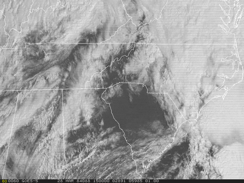
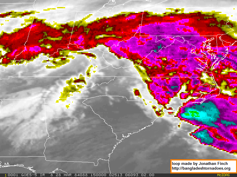
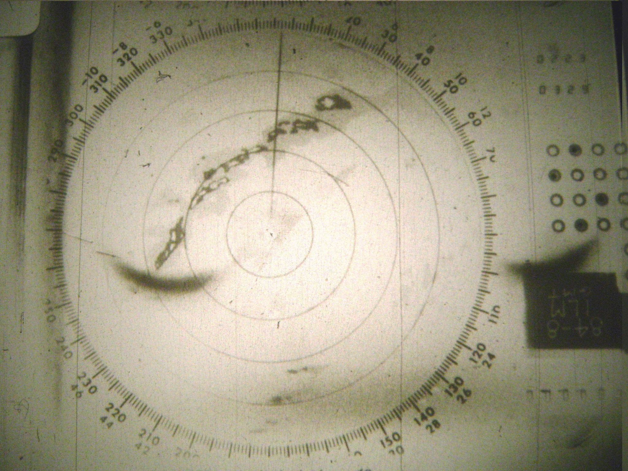
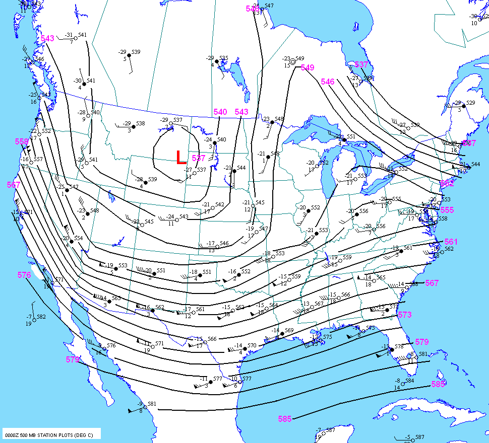
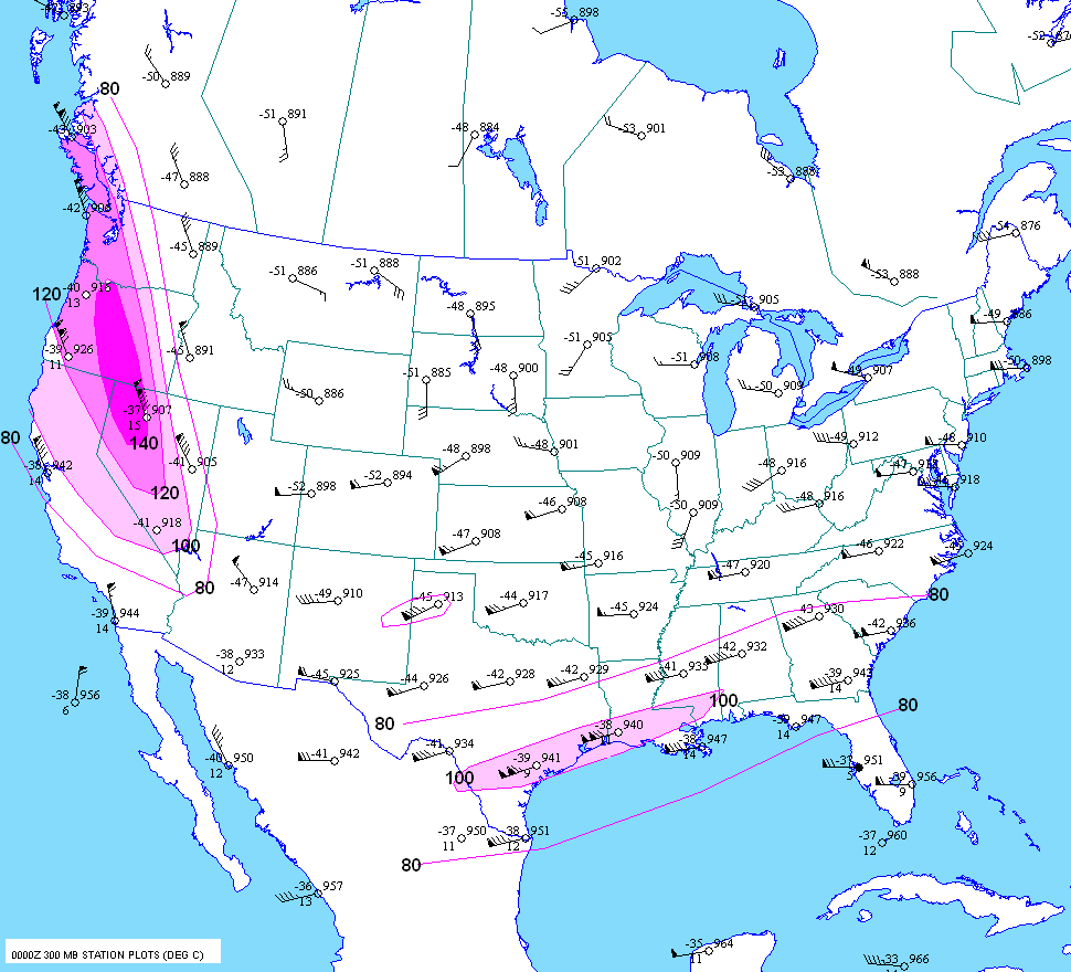
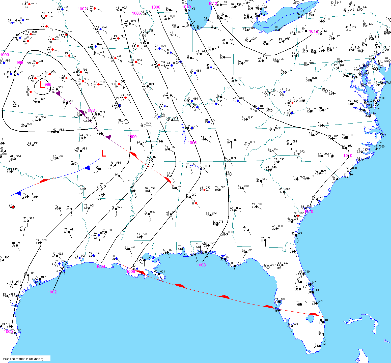
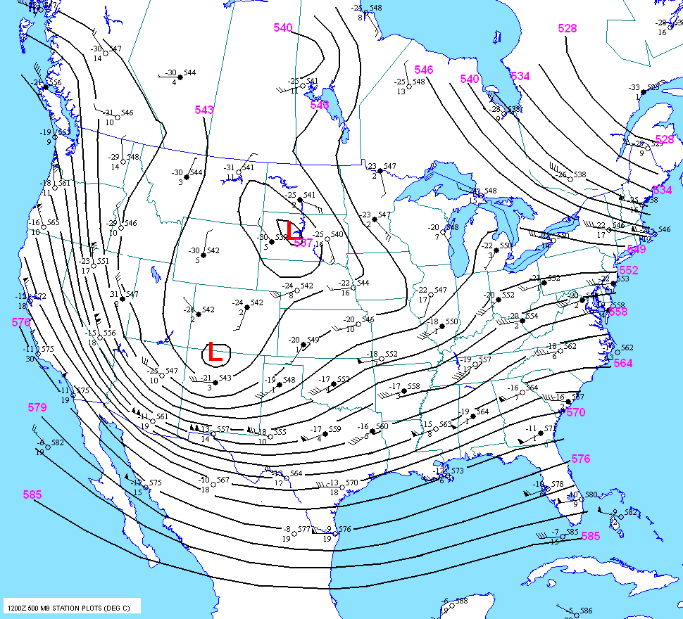
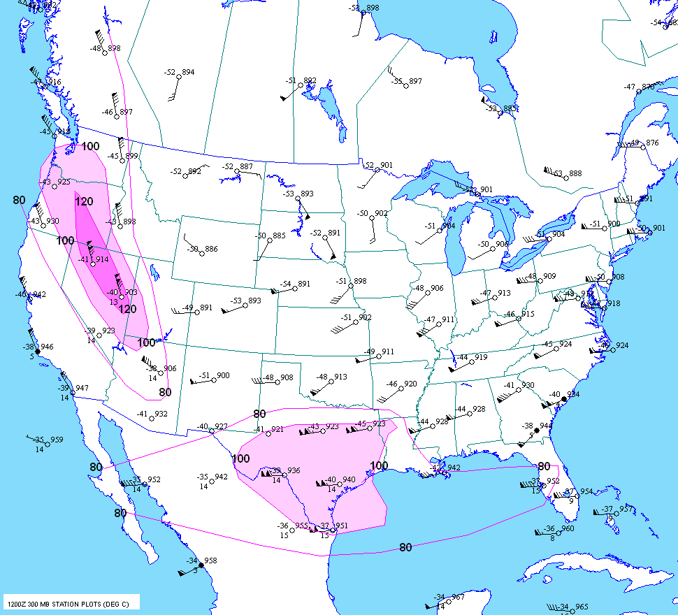
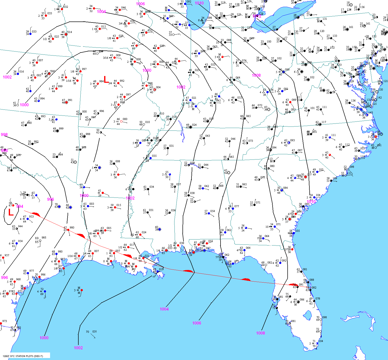
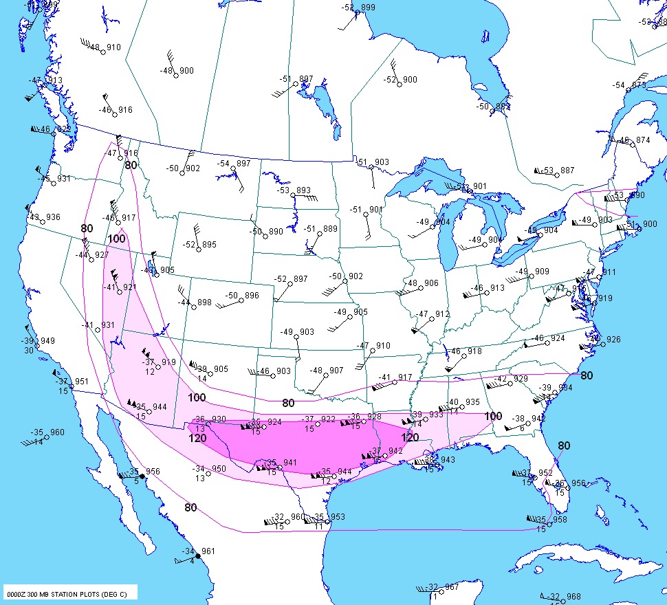
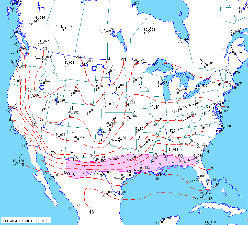
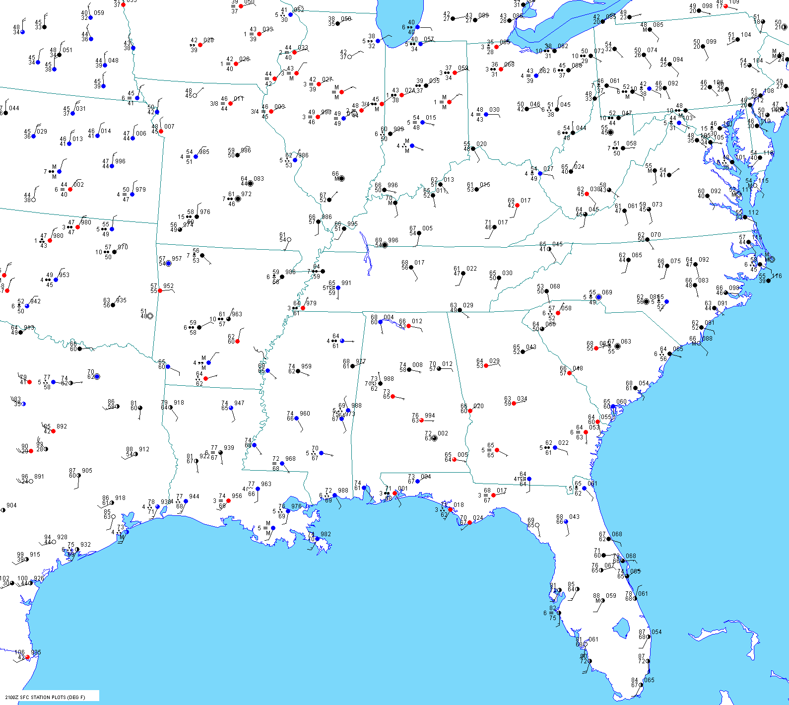
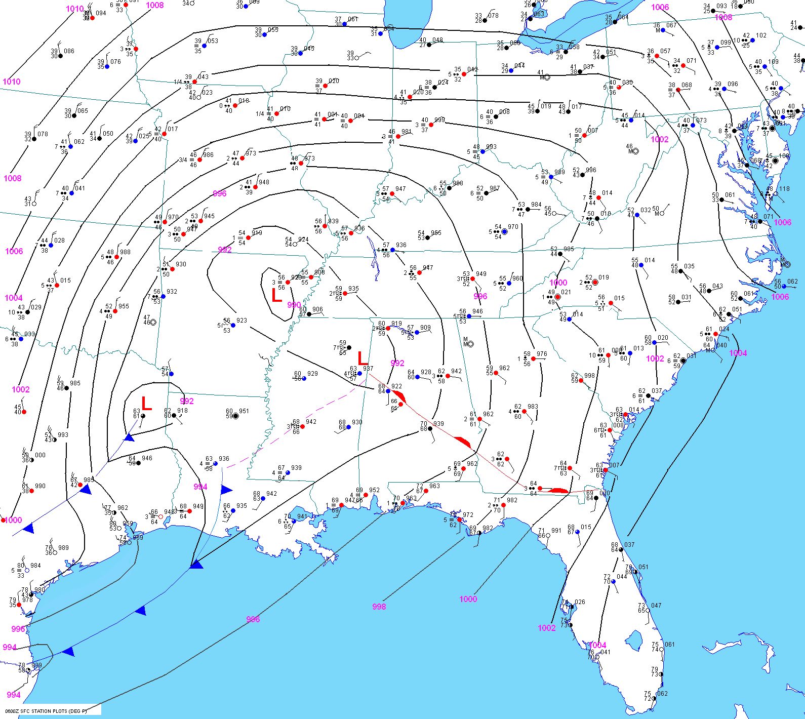
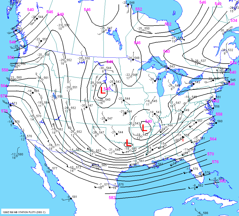
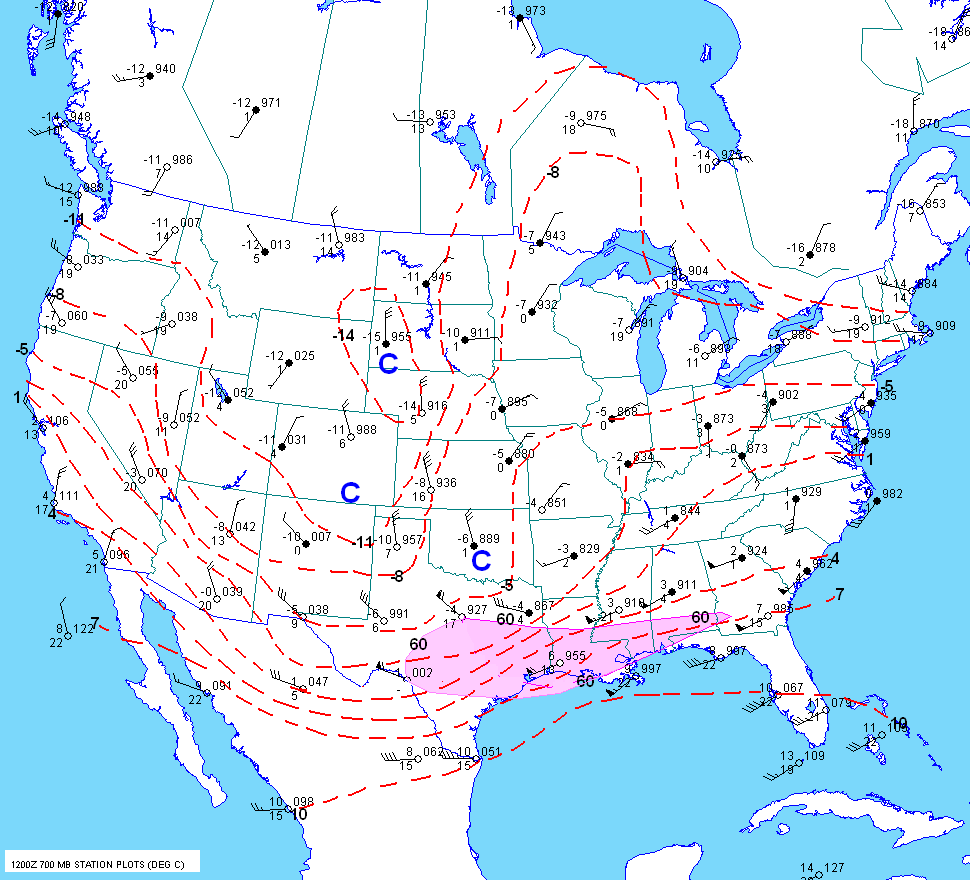
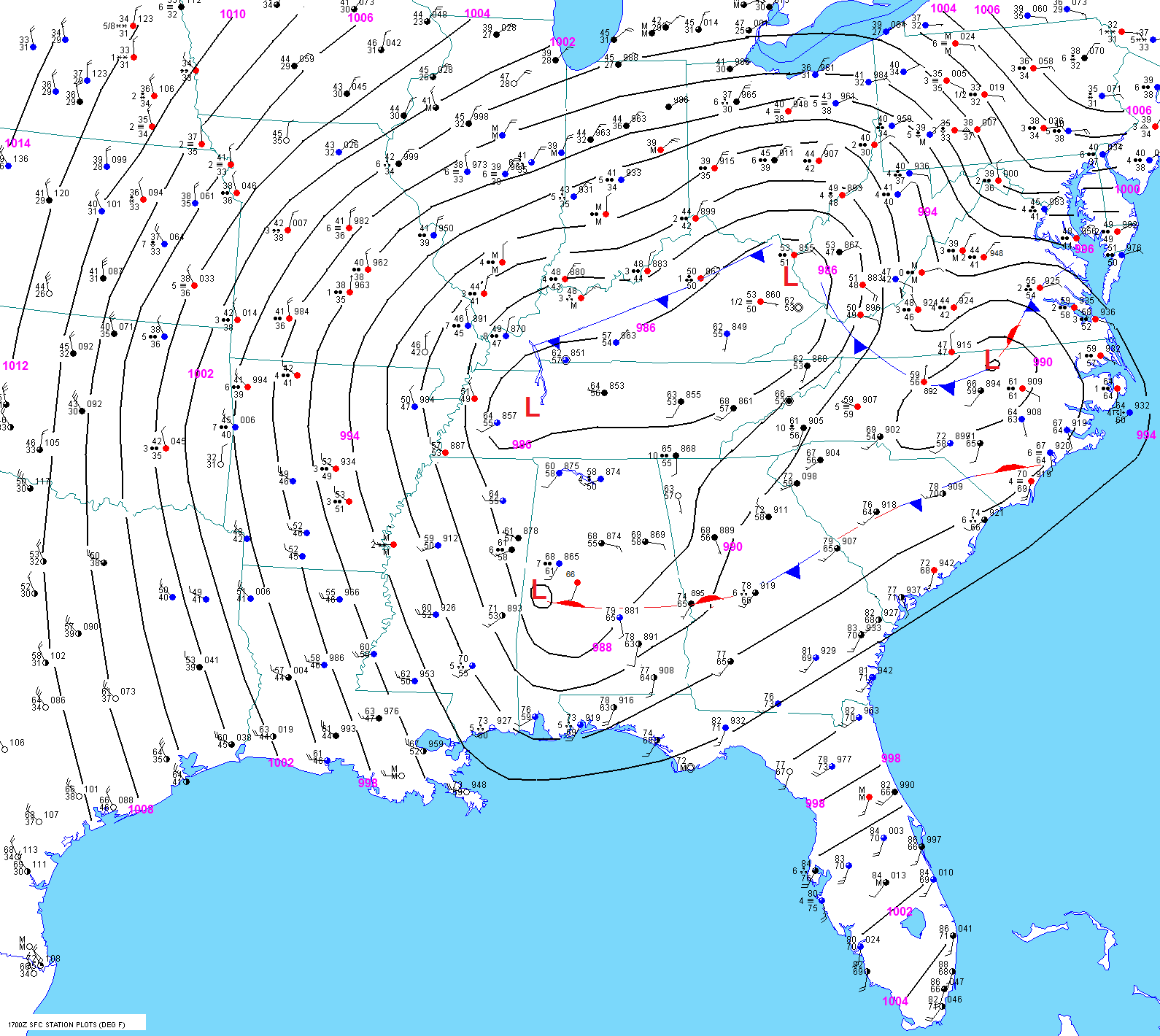
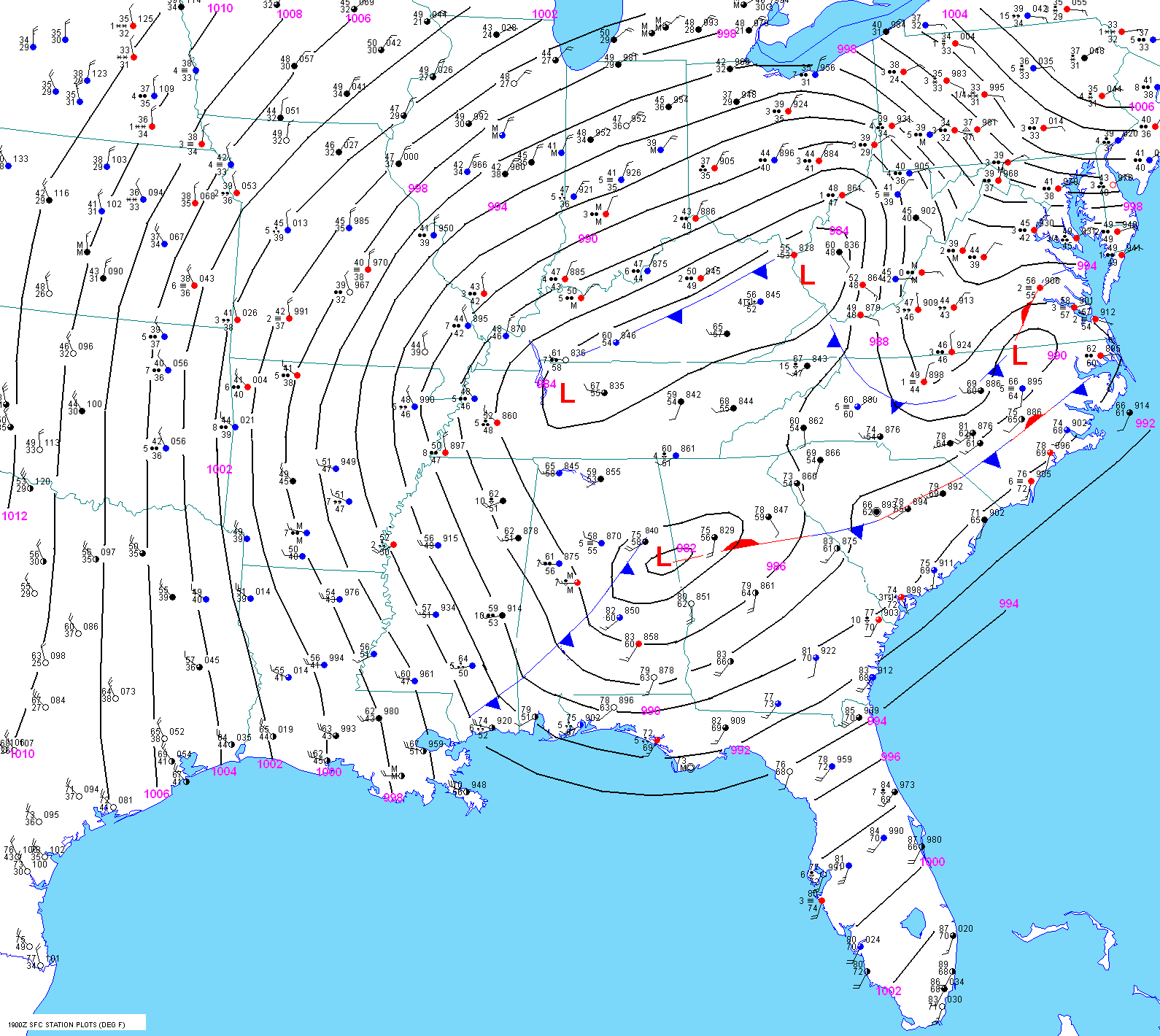
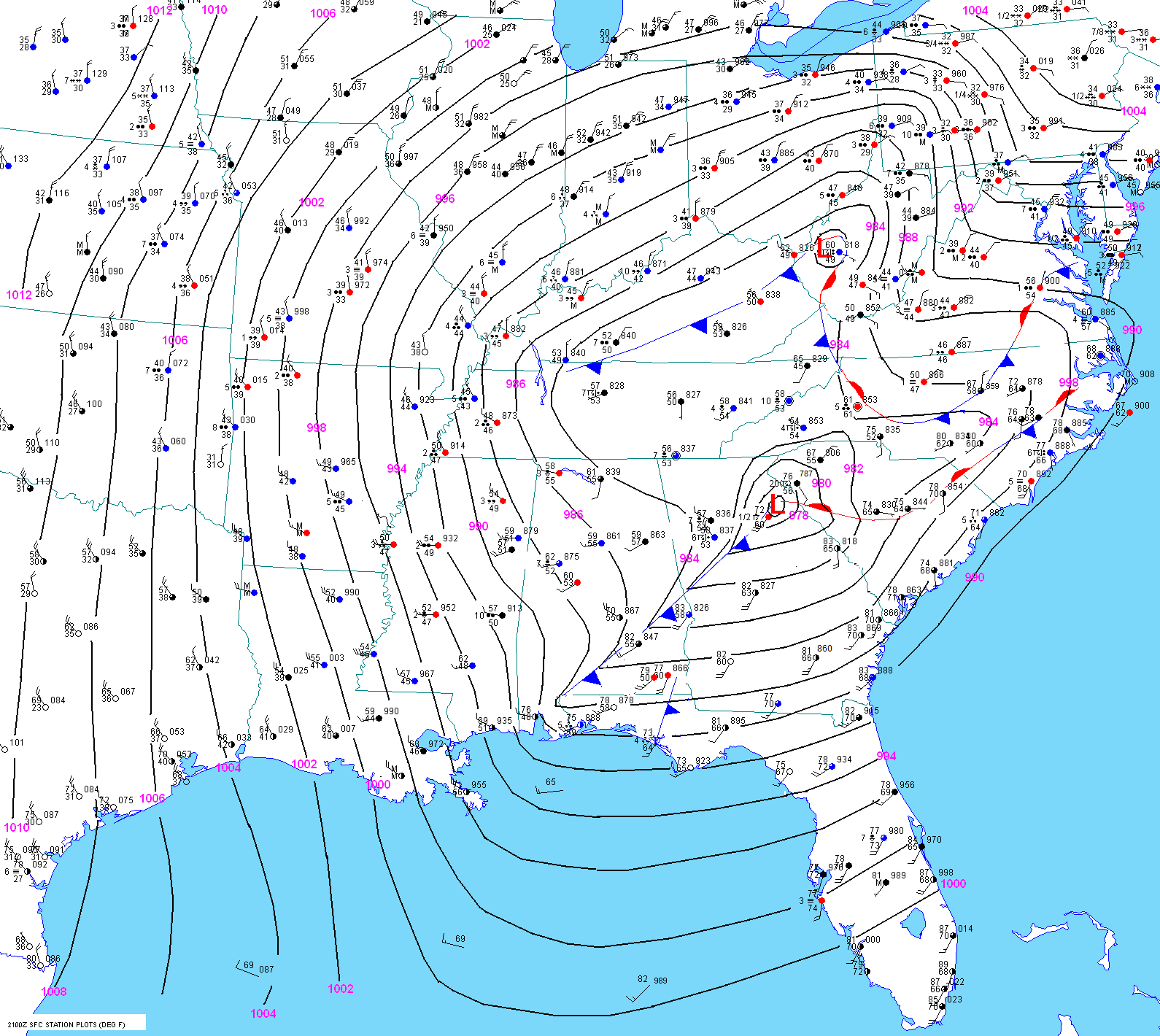
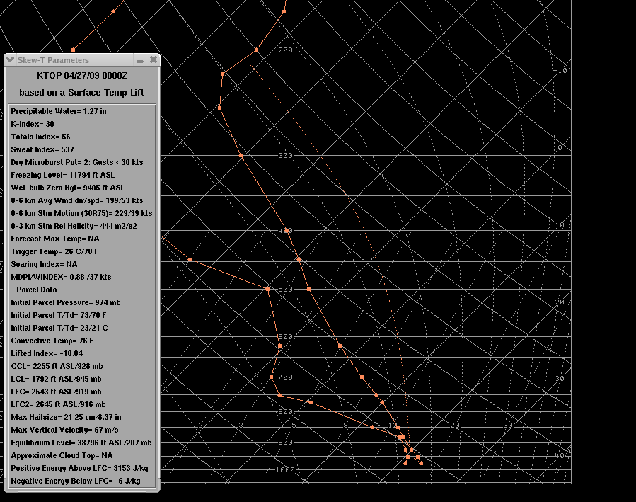
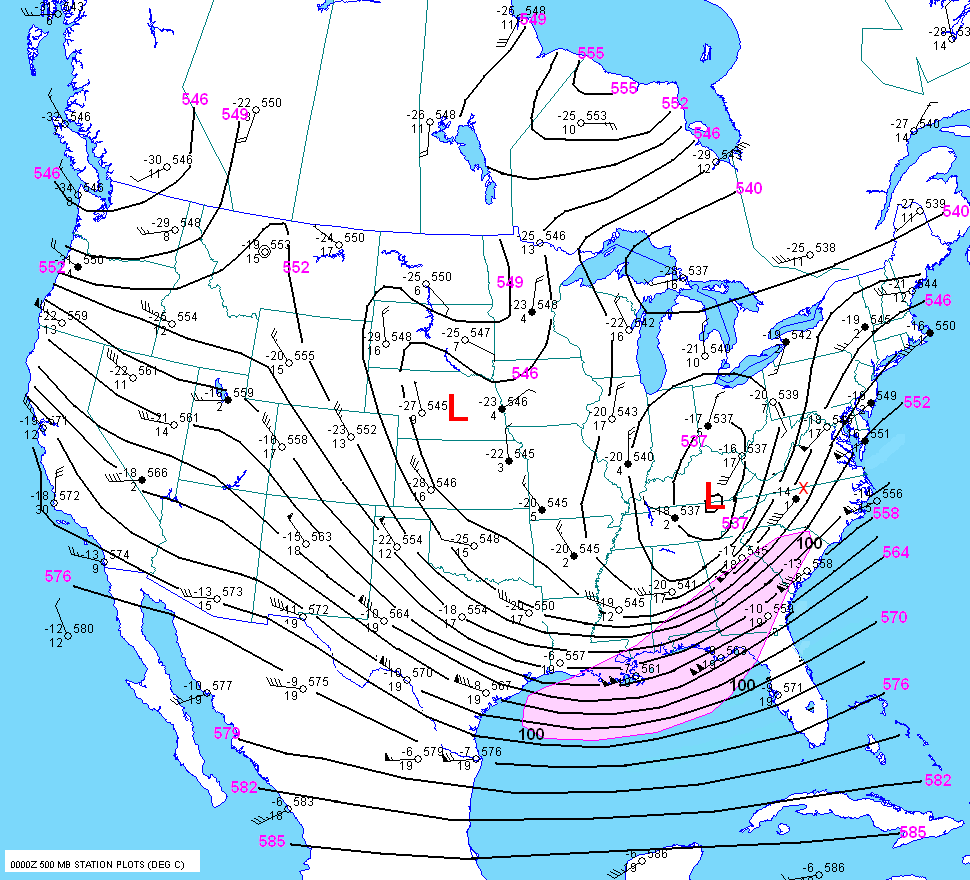
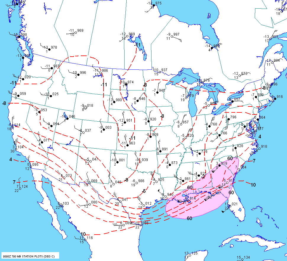
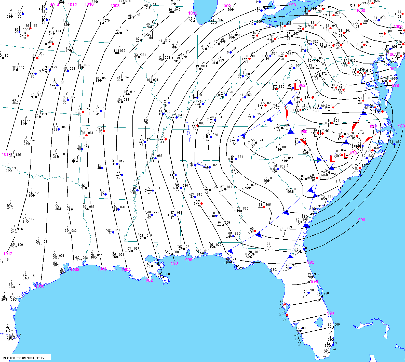
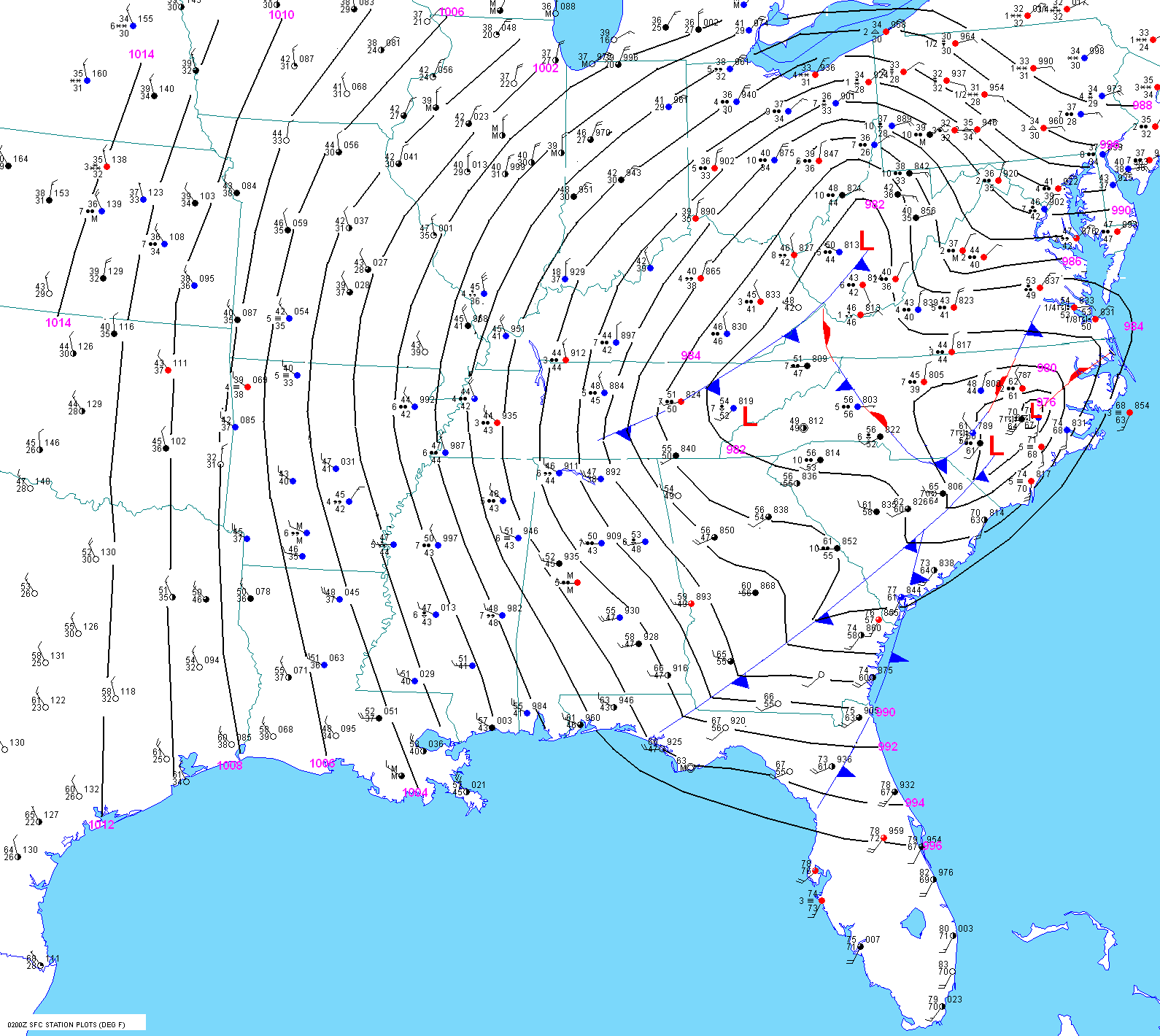
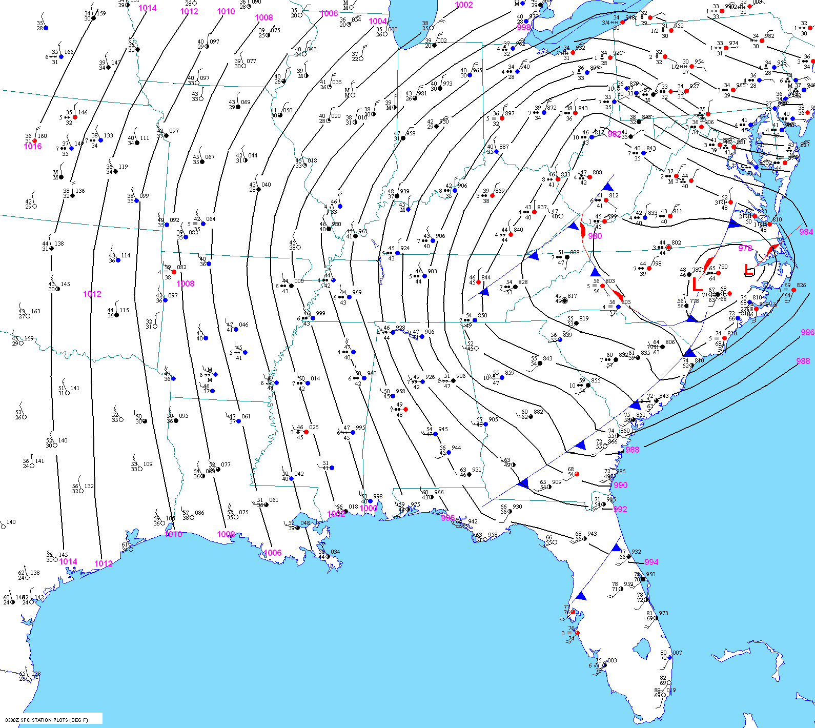
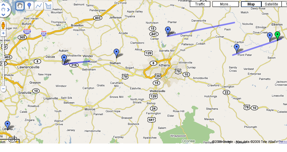
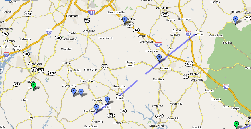
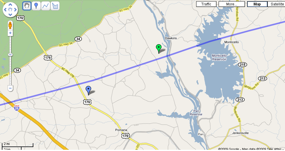
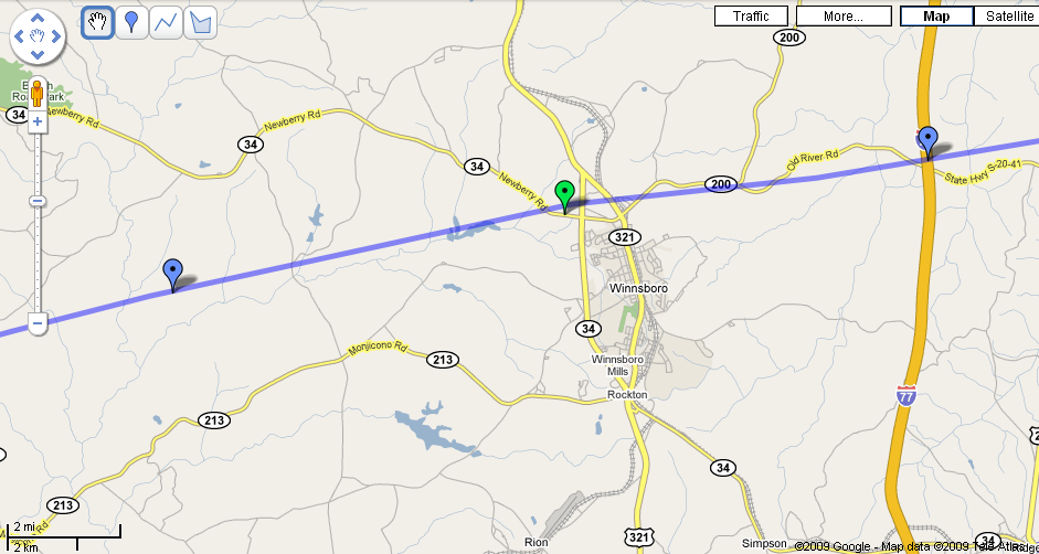
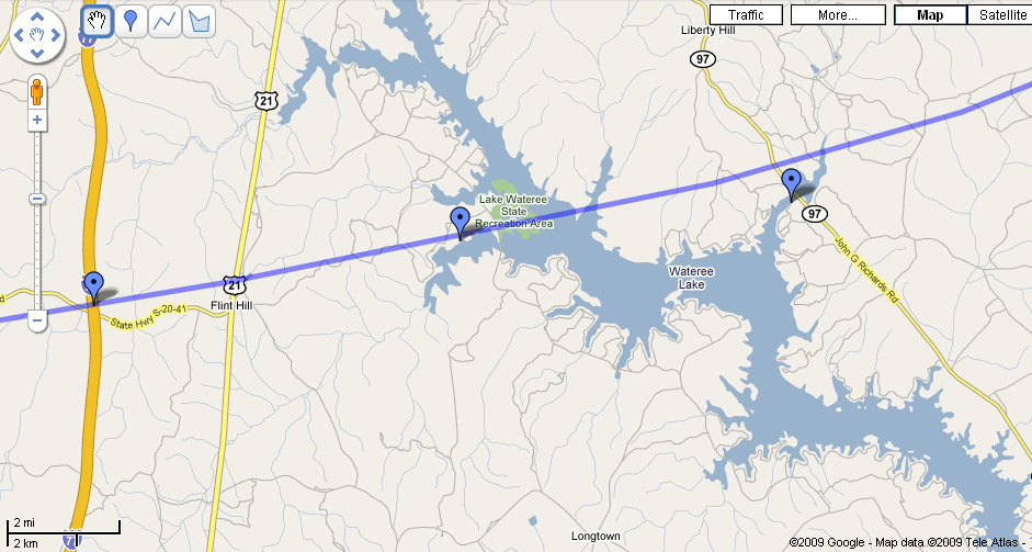
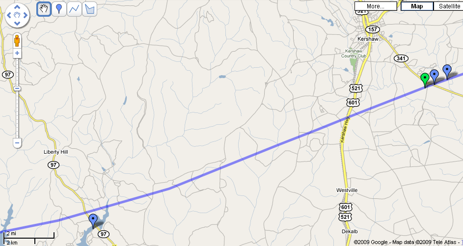
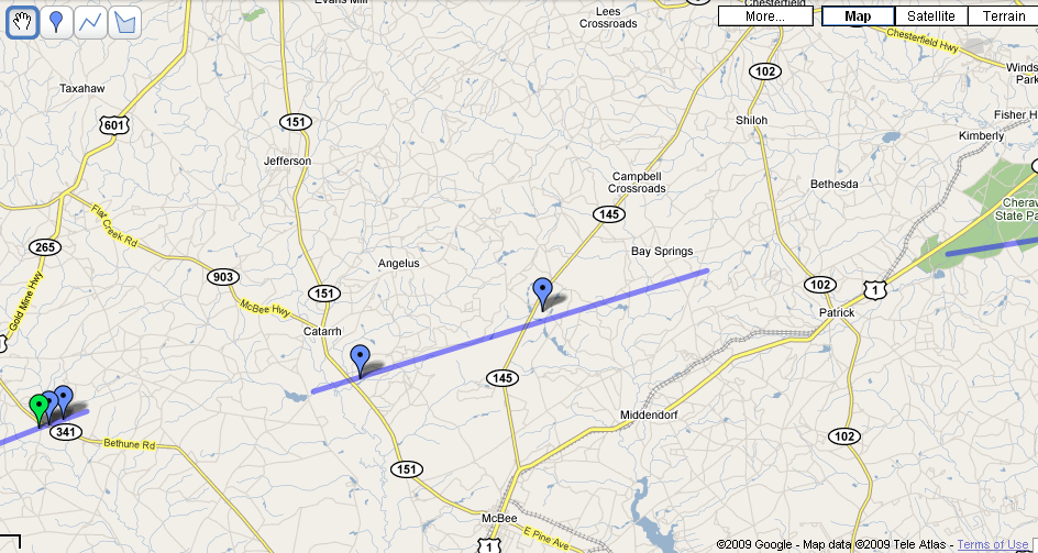
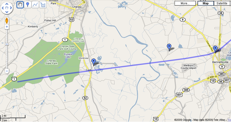
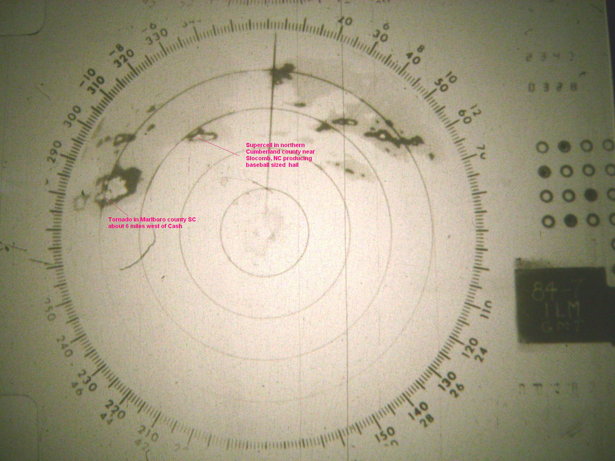
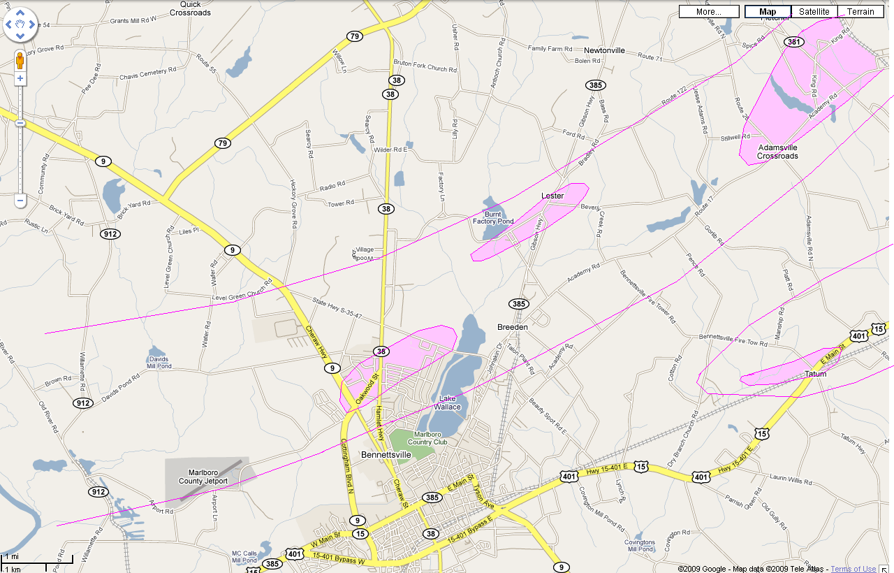
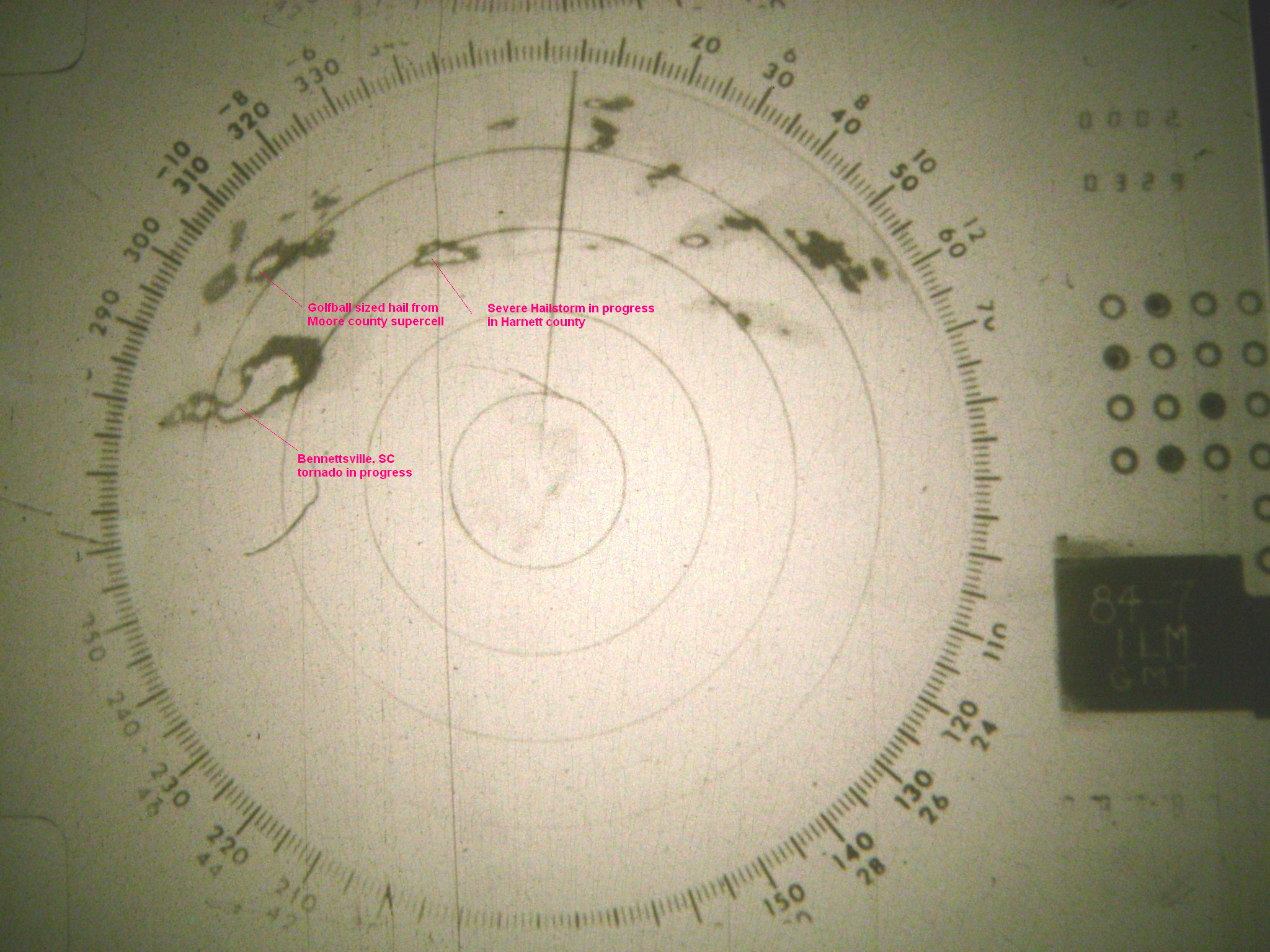
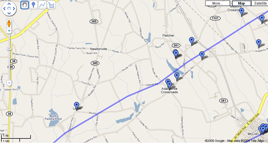
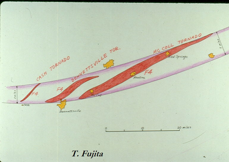
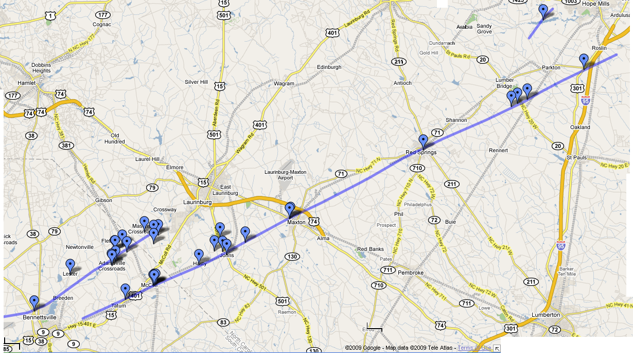
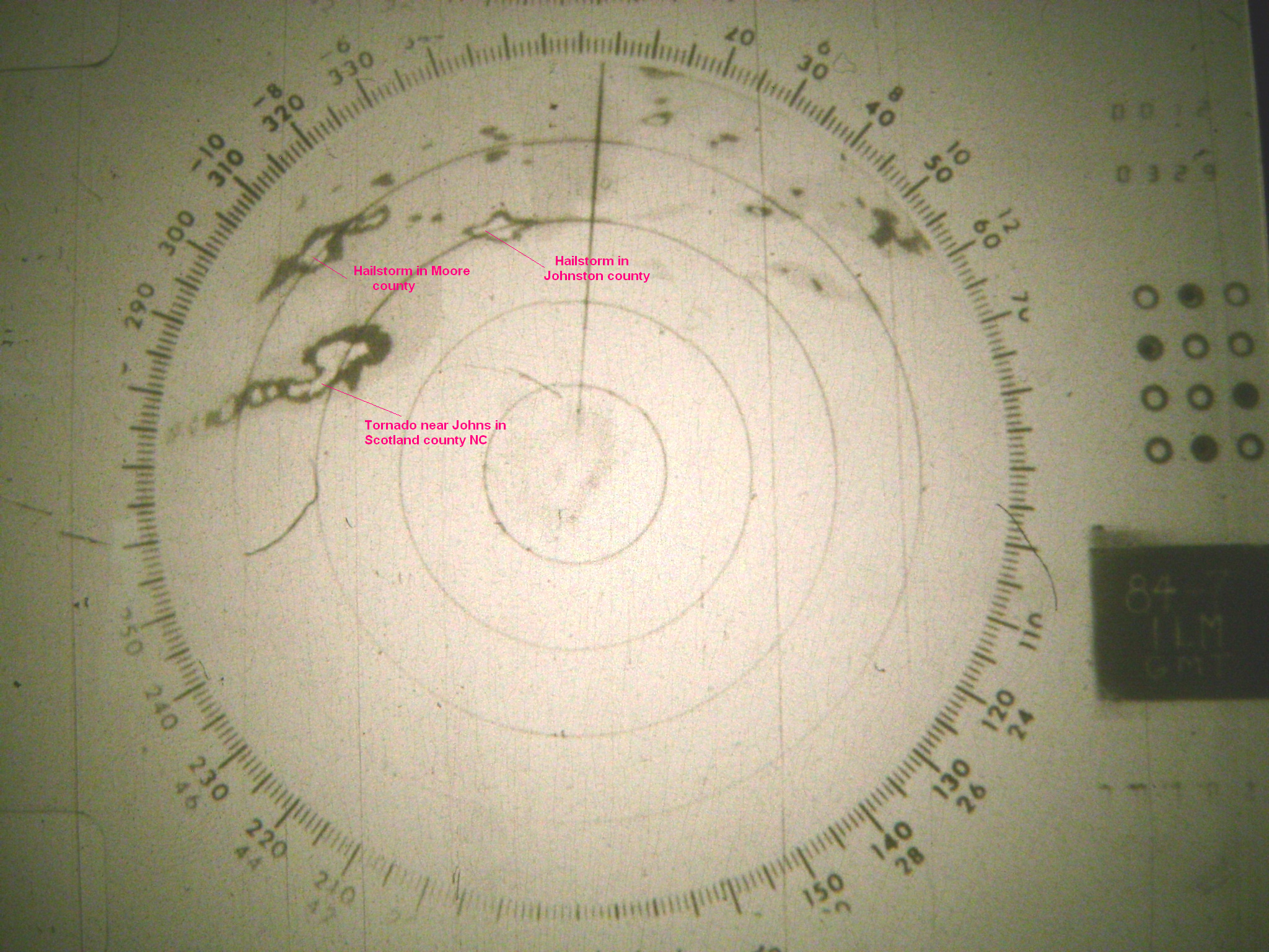
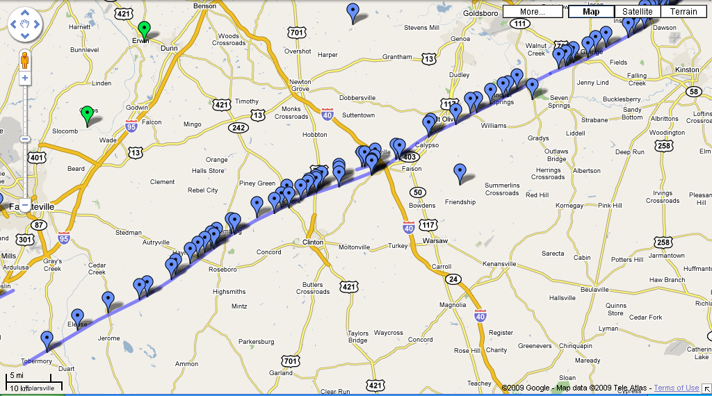
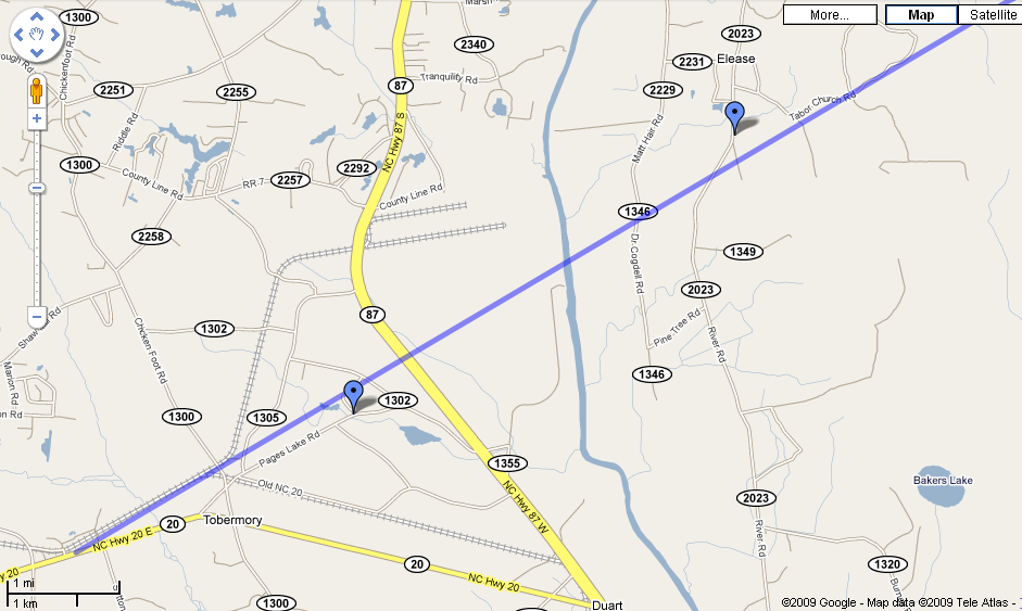
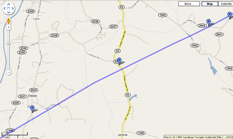
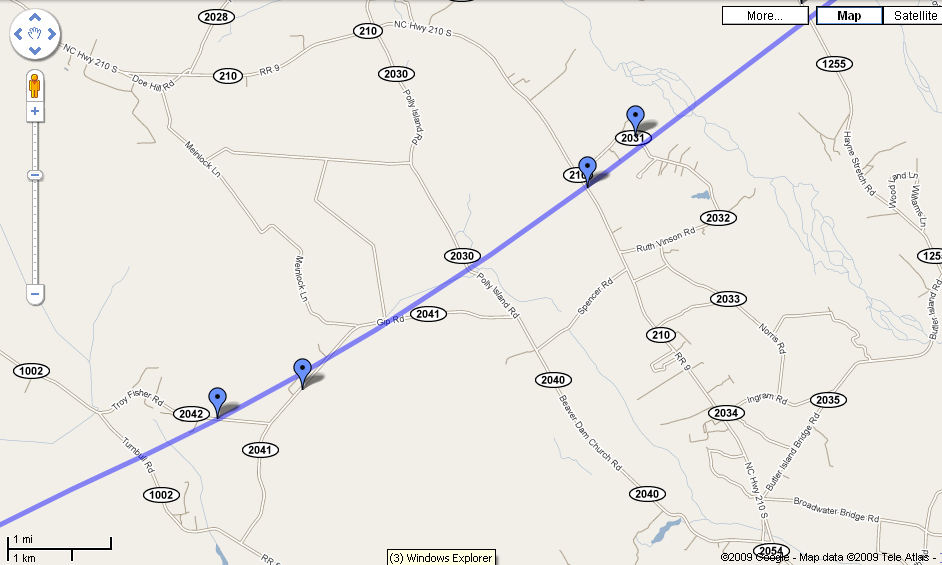
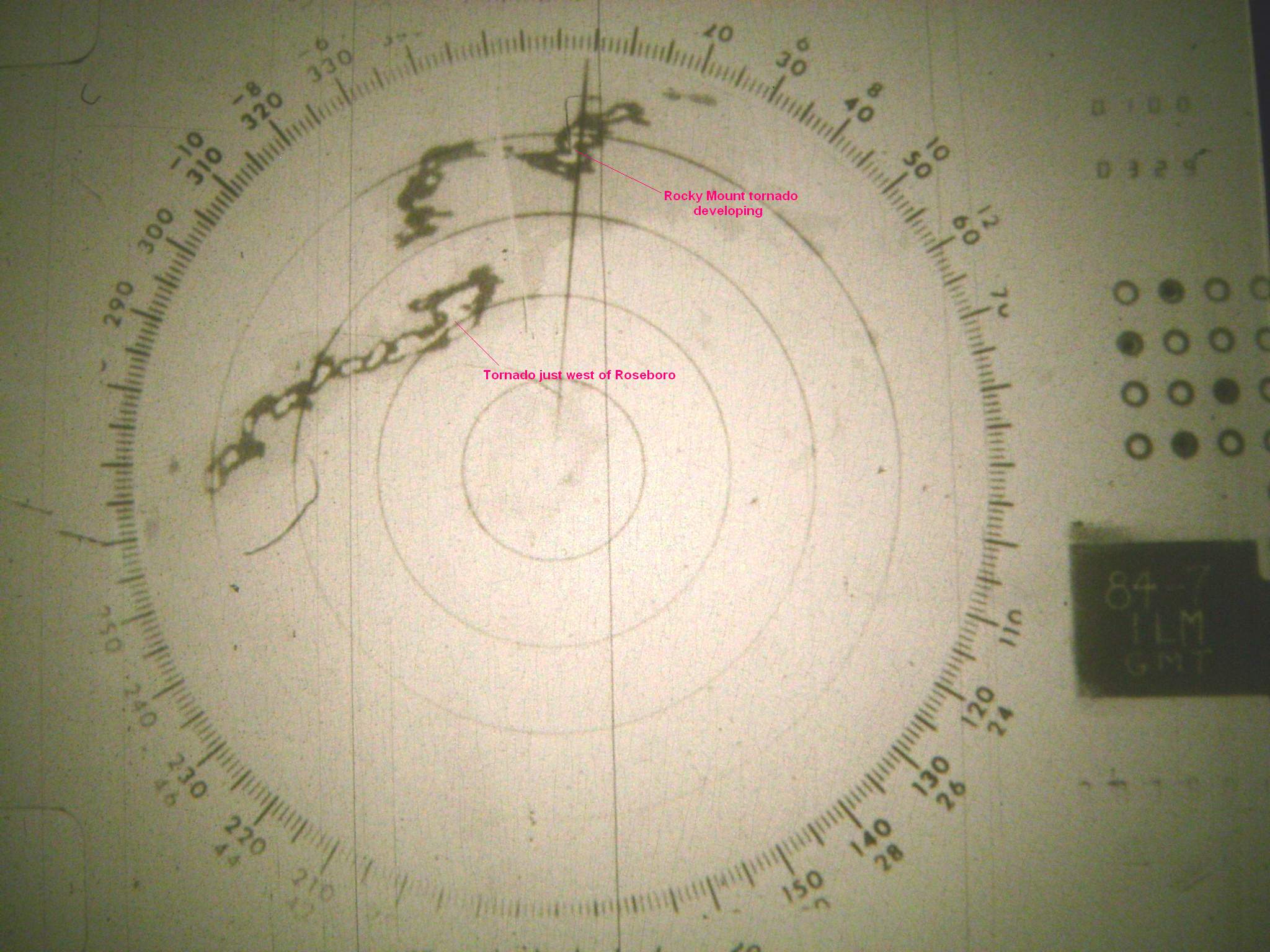
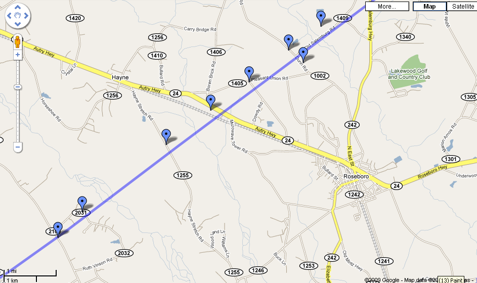
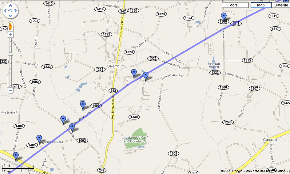
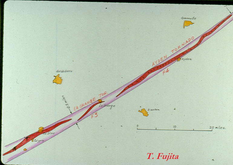
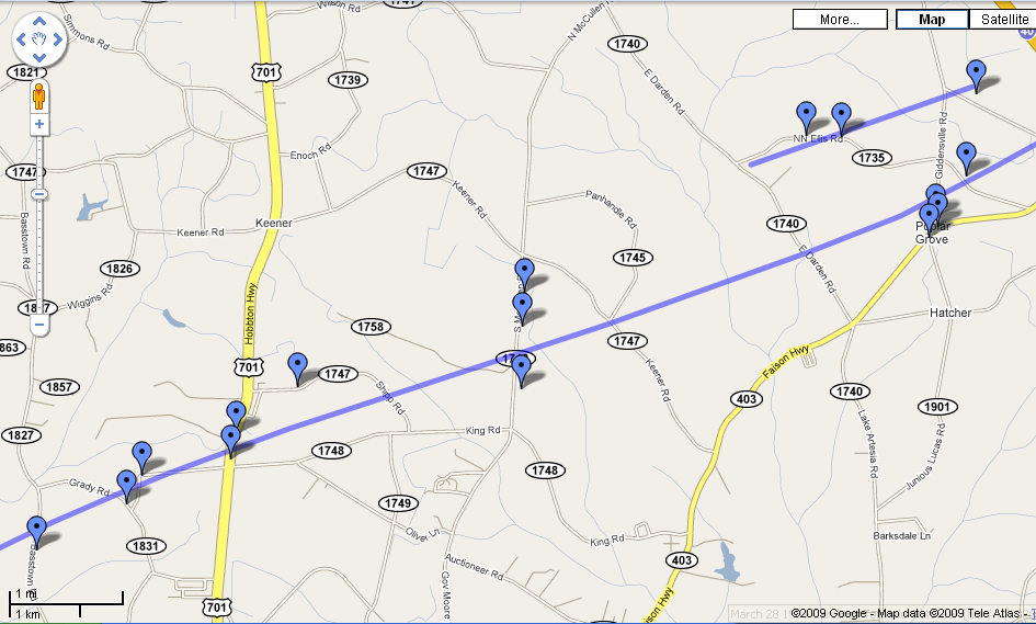
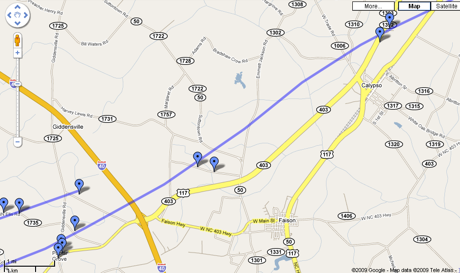
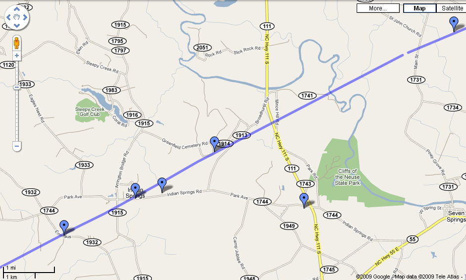
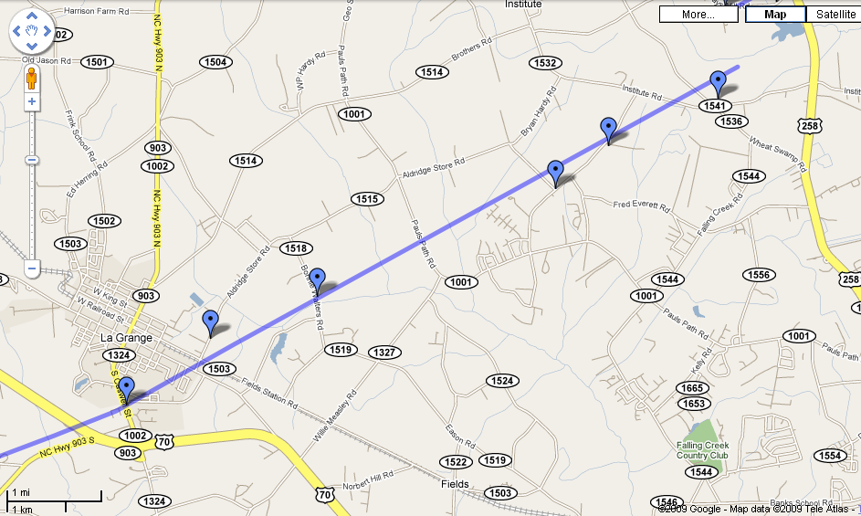
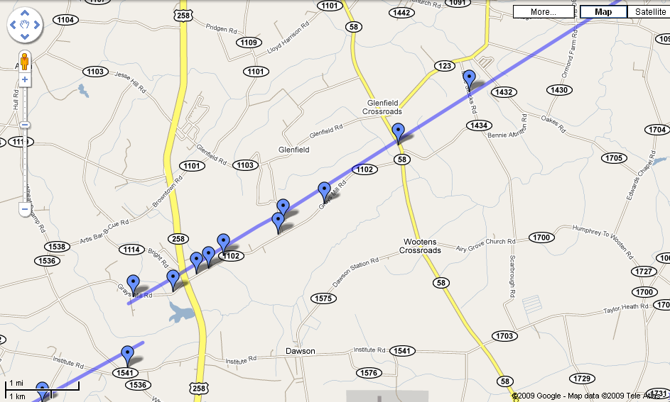
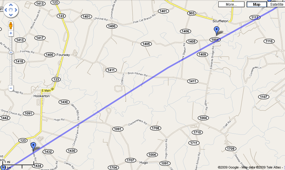
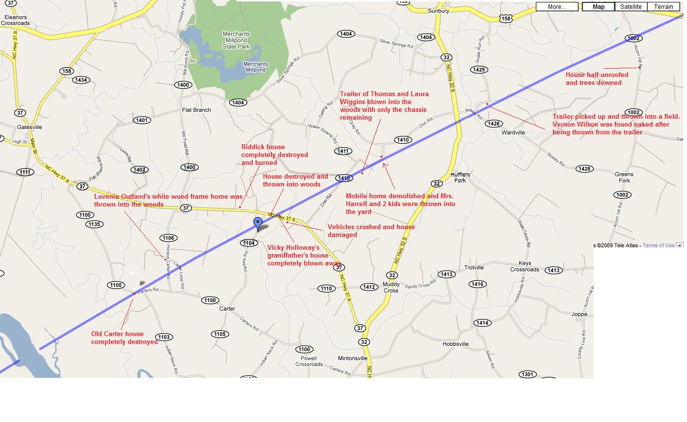
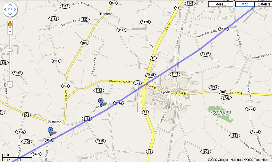
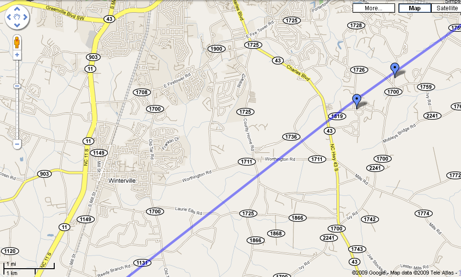
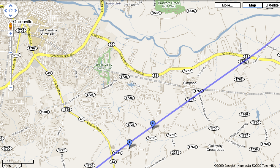
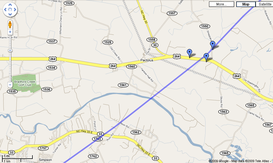
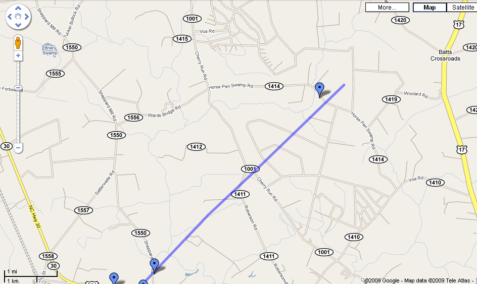
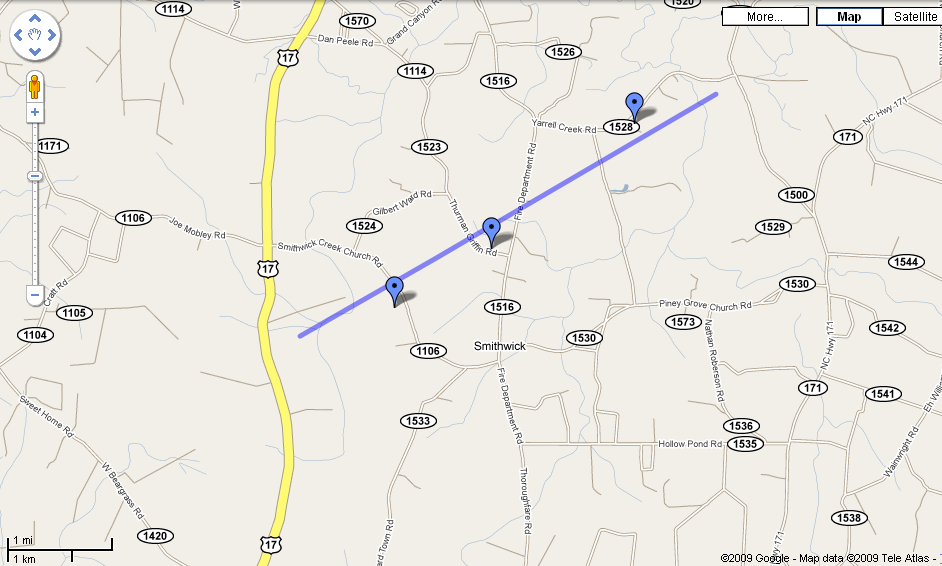
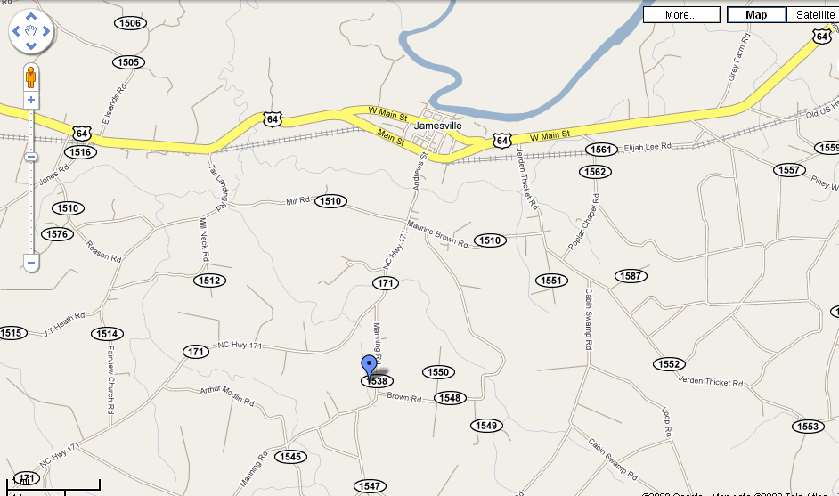
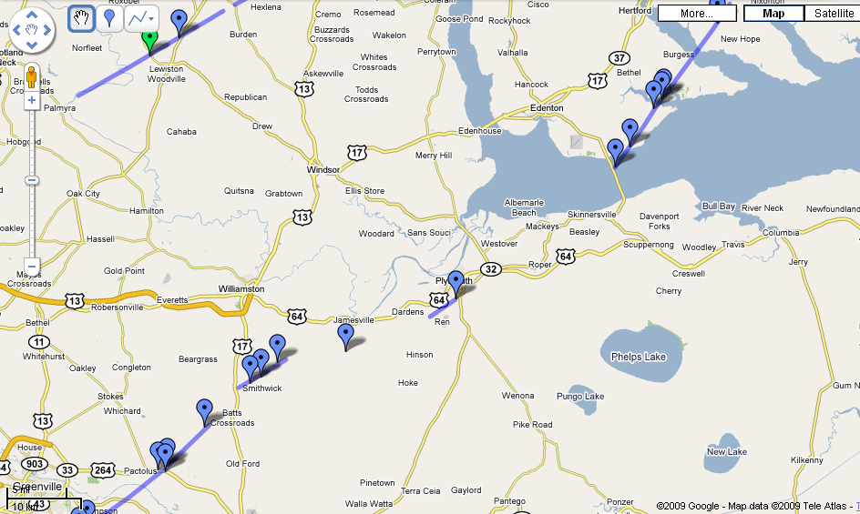
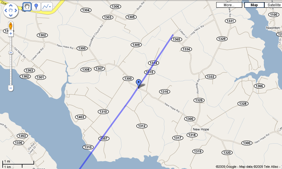
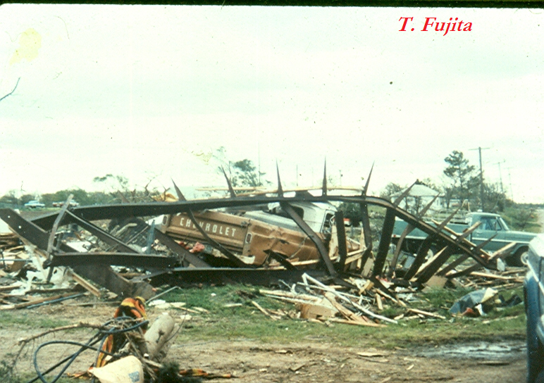
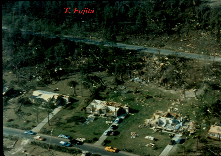
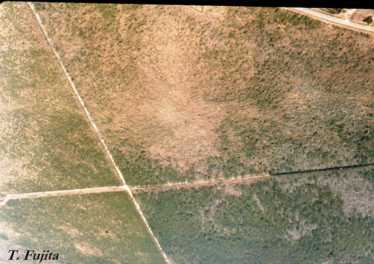
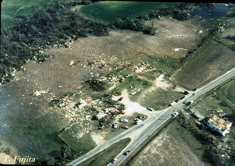
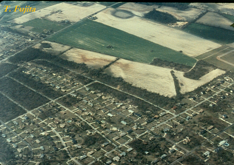
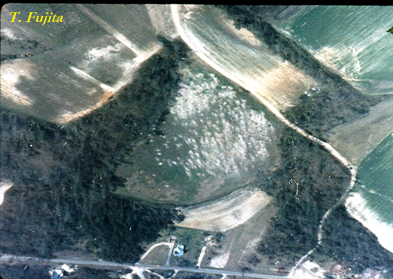
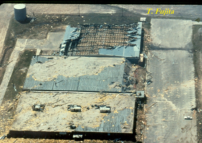
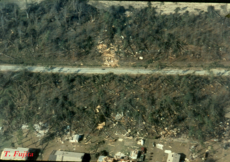
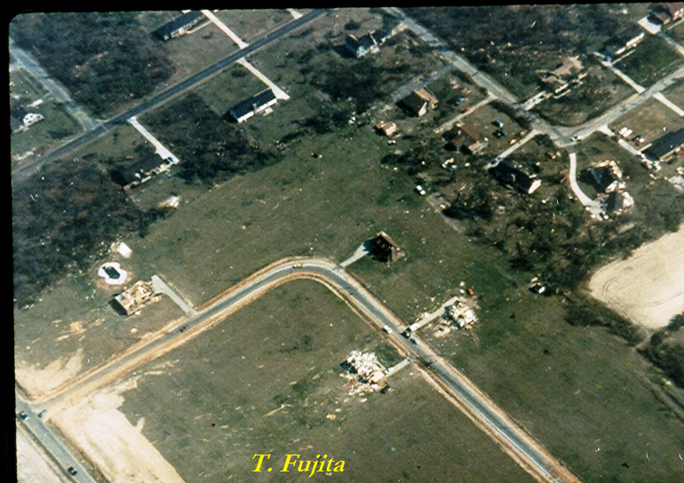
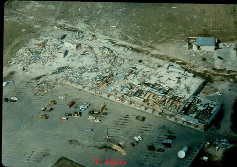
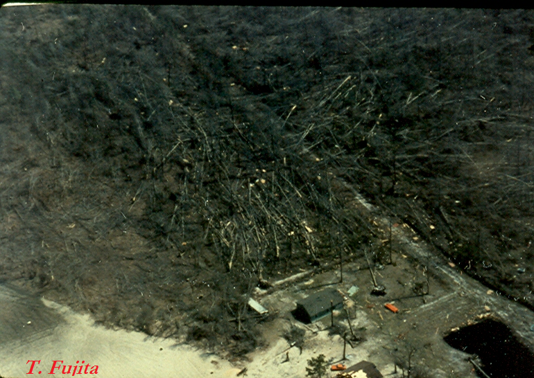
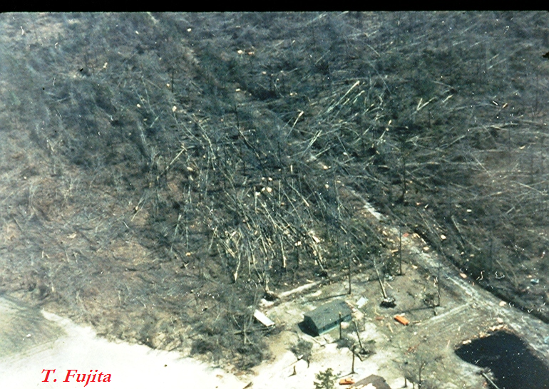
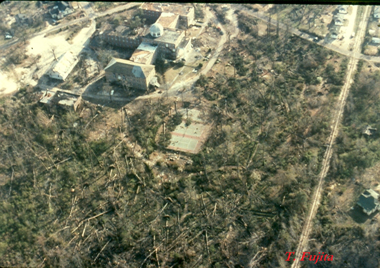
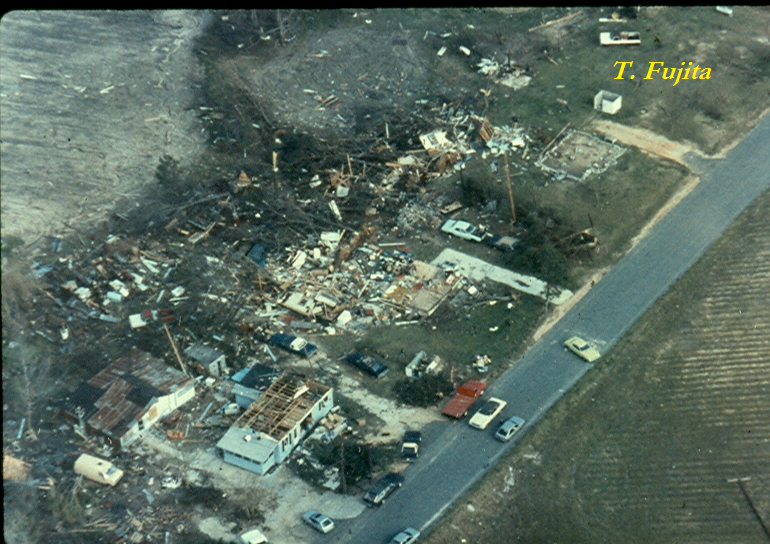
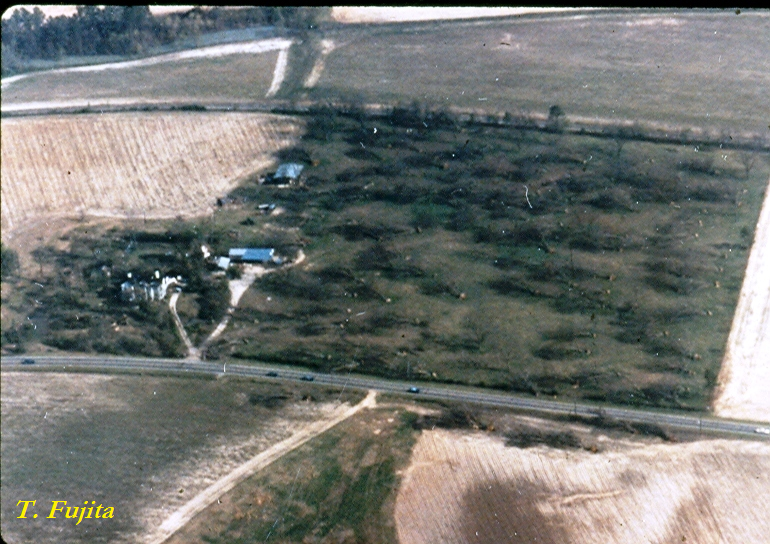
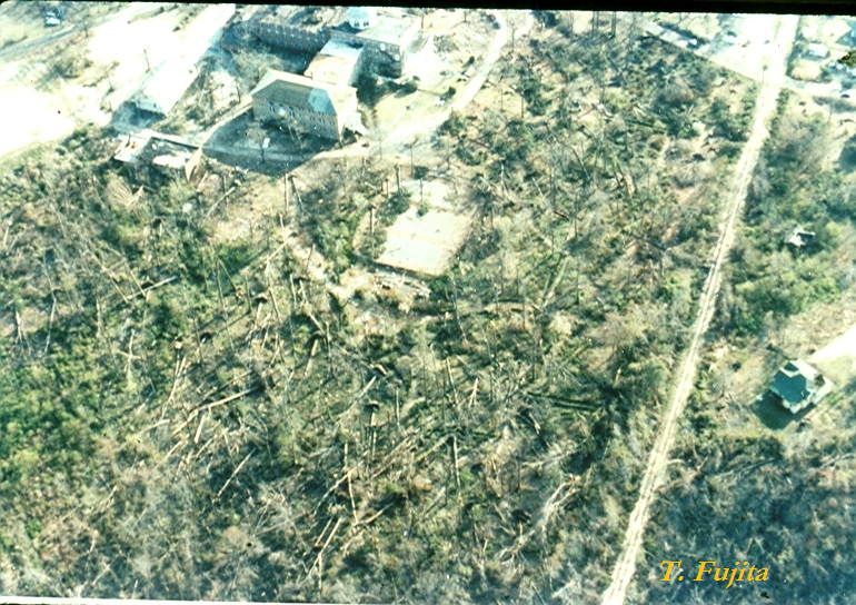
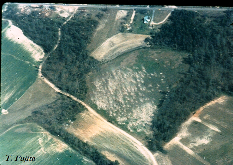
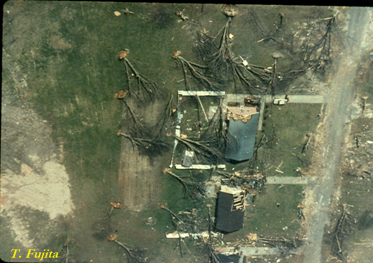
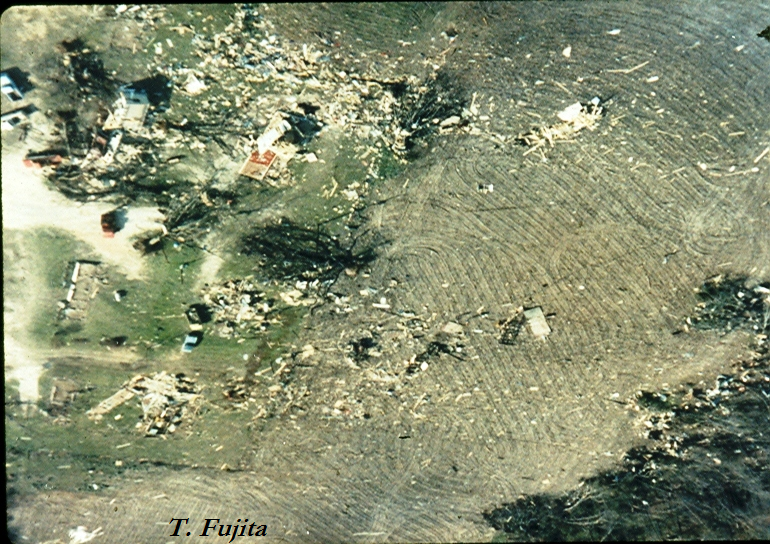
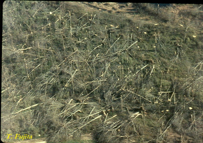
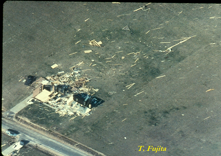
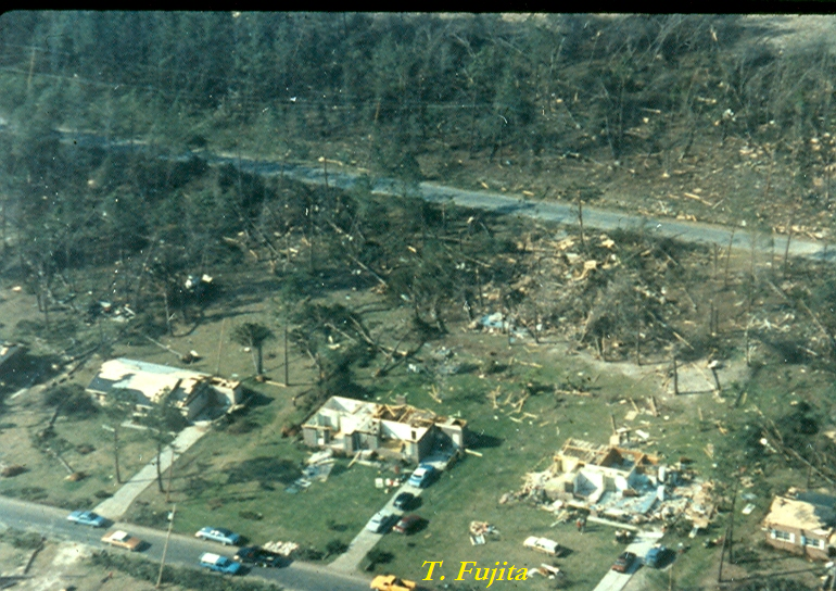
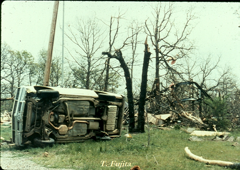