Instability Approximation for Woodward Tornado
The raob network was in its infancy in the late 1940's. Upper air data
were fairly sparse and undependable. Unfortunately, NCDC
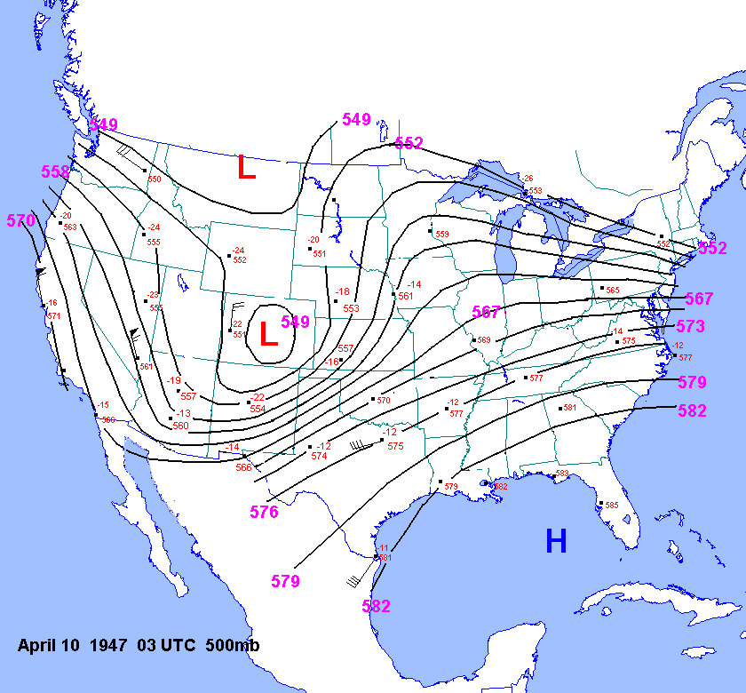
has lost these data. I did manage to obtain some UA maps for 03 UTC for
the late 1940s from Bobby Prentice. These maps are
fairly hard to read. but using these maps I managed to reconstruct the
500mb chart for 03
UTC April 10, 1947.
However, it is possible to approximate instability on the western plains
and high plains in some cases without the assistance of upper
air data. For details about how this is accomplished, see my page on calculating
instability on the high plains in the absence of
upper air data. To accomplish this for the 1947 Woodward tornado event,
we will make an assumption about the thermal profile
over the southern Rockies and southern front range. Namely, when very strong
mixing is occurring with partly cloudy to clear skies,
the thermal profile trends toward dry adiabatic from the surface to 500mb
by noon local time. Be cautious when using this method.
One must make sure that gusty winds and abundant sunshine are present,
along with station elevation generally above 4000ft and
surface dewpoint depressions > 40F. The method works best for stations
above 5000ft. Using stations below 5000ft can result in
500mb temperatures that are too cool by 1 to 2C. This method works best
for stations such as Santa Fe, Albuquerque, Laramie,
Alamosa, Rawlins, Eagle, Rifle, Cheyenne and Rock Springs with surface
dewpoint depressions >40F.
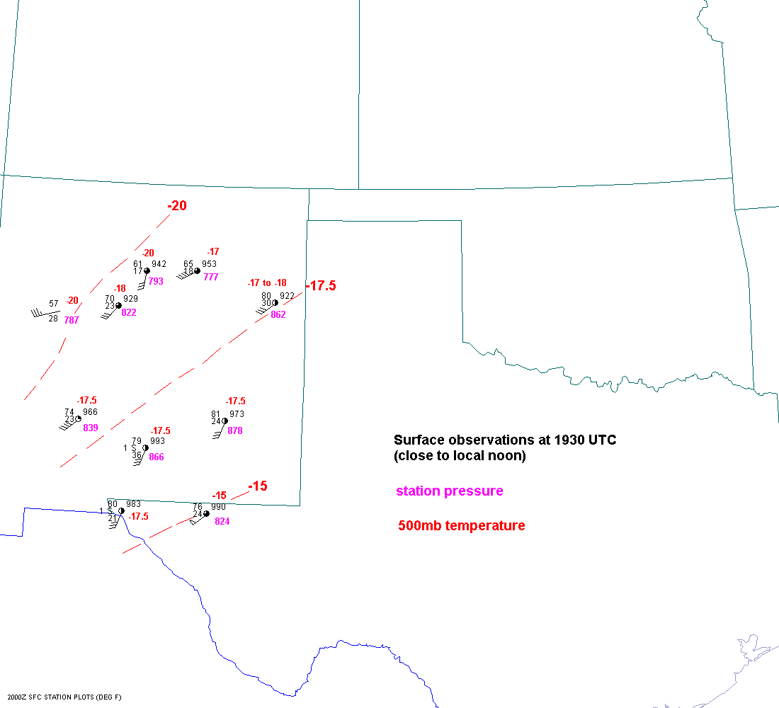
At 1930
UTC(close to local noon) on April 9, 1947, gusty south to southwest
winds were noted across most of New Mexico and
the Big Bend region of Texas, implying strong SW flow at mid-levels. The
station pressure for each observation is shown in pink.
For example, the surface temperature and station pressure at Guadalupe
Pass, TX were 76F and 824 mb. The surface winds was
the southwest at 50 mph. Now take this temperature up the dry adiabat to
500mb and see that the 500mb temperature at GDP was
approximately -15C. This same procedure was down for all the stations shown
on the surface map that were south of the warm front.
Further west and north, I found 500mb temps of -17.5 at Engle, -18 at Albuquerque
and -20C at Acomita and Santa Fe. The warm
front was just moving north through Tumumcari at noon, so deep mixing was
accomplished a little later there. So the 2030 UTC surface
observation was used there to yield a 500mb temp of -17C. So, there was
a 500mb temperature gradient from NW to SE across
New Mexico. Also, note that surface winds were generally gusty from the
southwest, with dewpoint depressions generally from 40 to
50F. These mid-level temperatures were undoubtedly representative of conditons
downstream over the Texas Panhandle. So, in my
estimation, the 500mb temps in the affected area that evening were between
-15C and -18C.
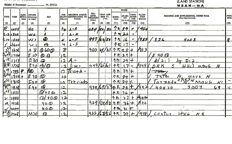
A tornado developed WSW of Pampa at 541 pm and passed north of Pampa by
610 pm. The surface
observations around this
time showed fairly high surface dewpoints in the upper 50s and lower 60s
with surface temperaures on the rise south of the warm
front. At 530 pm and 630 pm the T/TD were 64F/61F and 69F/59F respectively.
The elevation of Pampa is about 3250ft. The
station pressure was 886mb. Using a skew-T log-P diagram one can easily
find the lifted index at Pampa assuming 500mb temps
between -15C and -18C. Lifting 64F/61F at saturation up the dry adiabat
and then up the moist adiabat to 500mb yields
-7C. So the lifted index ranged from -8 to -11
at Pampa when the storm was to the WSW. After the storm moved north the
T/TD were 69F/59F, which has nearly the same theta-e as before. Further
east in northwest, OK, dewpoints may have been
higher, but the elevation drops off to between 2000 and 2500ft. Thus, surface
potential temperatures were probably lower.
So instability was probably similar at Pampa and in northwest Oklahoma.