Assessing Instability on the Front Range Without
Upper Air Data
Jonathan
D. Finch
Links
Main
Page
Elevated
Mixed Layer
Convective
Outlooks for Bengal
Special
Cases for the United States
Bengal
Tornadoes--background information
Meteorological
Charts for Historical Tornado Cases for Bengal
Latitudinal
Comparison of the Geostrophic Wind Approximation
Potential
Temperature and Mixing Ratio--Contributions to CAPE on Elevated Terrain
A few years ago(sometime
in the late 90's) I came up with a simple technique for assessing instability
on the front range without the
assistance of upper air
data. A lot of information about the upper air can be determined through
the appropriate use of surface data.
The best way to show how
this technique works is through a case study examples.
Case 1
On June 25, 1942,
a thermal low was situated in the northern Texas panhandle, with a nearly
stationary frontal boundary stretching
from central Wyoming into
central Colorado and then east into the panhandles and finally north and
east into eastern Kansas and
Missouri. North of the boundary,
moist upslope flow was noted across northern Kansas, Nebraska and eastern
Wyoming. Another
area of surface low pressure
(probably a thermal low) was located in the northern Rockies. A rather
diffuse surface dryline was
located across west Texas.
A cold front stretched from eastern Idaho into western Utah. Ahead of the
front, a very warm plume of
air covered much of the
central and southern Rockies.
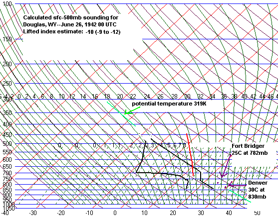
By midday--1230 MWT(mountain
war time), surface temperatures under the warm plume included 77F at Fort
Bridger(7040 ft
or 781mb), 78F at Rock Springs(6760
ft or 789mb), and 86F at Denver (elev. 5300ft or 834mb). Skies were also
mostly sunny.
These temperatures lie nearly
along the same dry adiabat on a skewt-logP
diagram with surface potential temperatures of 115F at
Denver, 114.6 at Rock Springs
and 116.2F at Fort Bridger.
With mostly sunny skies and
brisk south to southwest surface winds, I assume that the thermal
profiles above these stations are close
to dry adiabatic from the
surface to 500mb. One can infer south to southwest upper level flow over
this region from these surface winds.
In such a flow regime, a
deep elevated mixed layer would most certainly move downstream and cap
the boundary layer over Douglas
and Cheyenne, WY.
Now simply take the midday
surface temperatures at Rock Springs, Fort Bridger and Denver(the most
immediate stations to Douglas
where hourly sfc data were
available in 1942) and move these up the dry adiabat to 500mb on a skewt.
This should be very close to the
actual 500mb temperature.Why
do I use midday surface data? Because in my experience, the thermal profile
is closest to adiabatic from
the surface to 500mb at
this time. In the mid to late afternoon, a strong superadiabatic layer
often develops near the ground. So using
data later in the day would
give a 500mb temperature that is too warm. Now take the surface temperature
and dewpoint at Douglas,
WY(elev. 4900ft or around
845mb) and lift this parcel up to 500mb(dry at first and then moist). Now
subtract this parcel temperature
from the estimated 500mb
temperature above Rawlins and this yields a 500mb lifted index of around
-10. There was a killer tornado
near Wheatand, WY that evening.
This technique works well
during the front range severe weather season(late-May to August) when 500mb
temperatures are slow to
change, especially over
a span of a few hours. Also, this is the time of year when the elevated
mixed layer is a given when southwest or
westerly flow is present
across the central and northern Rockies. Of course, severe local storms
are rare on the front range from October
to April anyway.
Case 2
On April 23, 1960,
strong upslope flow was advecting moisture into the western high plains
and front range of northeast Colorado
and southeast Wyoming. Oftentimes
in spring, upslope flow only results in cool temperatures and low clouds.
But southerly mid-level
flow helps warm up the750-650
mb layer, leading to steep lapse rates overlaying the moist upslope. The
result in this case was
moderate instability. Also,
with easterly low-level flow and southerly md-level flow, vertica wind
shear was impressive.
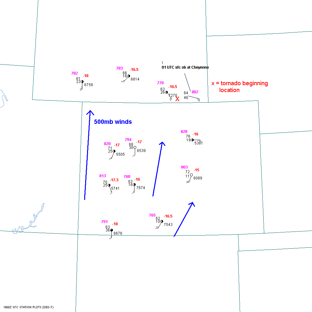
At 19
UTC(noon MST), surface temperaures had climbed into the 60s
and 70sF at the regular reporting stations in Colorado
and Wyoming. Take the sfc
pressure and temperature at each location and go up the dry adiabats to
500mb. This yields the
500mb T. Denver was north
of the warm front until mid-afternoon so we used the mid-afternoon sfc
observation there.
The 500mb T was -16C
at Denver, -16.5C at Rawlins, Laramie and Alamosa, -17C at Eagle,
Rifle and Montrose, and -18C at
Rock Springs and Durango.
Colorado Springs was the warmest at -15C. Note that these temps are fairly
uniform, with a slight
decrease to the west. One
can roughly estimate the 500mb wind direction from the sfc wind direction
under well mixed conditions.
In this case the surface
winds were generally from the south or southwest. Taking friction into
account, the upper level flow was southerly
or southwesterly. I estmate
from the above information that the 500mb temp at the tornado location
and at Cheyenne at 01 UTC was
between -15C and -18C, but
most likely between -16C and -17C. Also note that the sfc T/TD at
Cheyenne at 01 UTC was
64F/46F at 802mb. Now we
have all the information we need to estimate a lifted index between -7
and -9. These findings are
corroborated by the 00
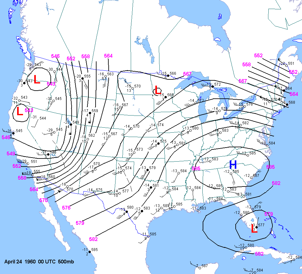
UTC 500mb chart.