May 4-5 1950 Tornadoes, Blizzard, Duststorm and Windstorm
Back to Lubbock Area Tornadoes Webpage
Back to Amarillo Area Tornadoes WebpageBack to Dodge City Area Tornadoes Webpage
Back to Wichita Area Tornadoes WebpageBack to Norman Area Tornadoes Webpage
Overview
On May 4-5, 1950 an interesting case of cyclogenesis occurred over
the plains states. All types of extreme
weather
occurred with this system including blizzard conditions,
tornadoes, a duststorm and high winds. A powerful
shortwave
trough ejected northeast across the plains in negative
tilt fashion. Strong surface cyclogenesis occurred with the surface
low
deepening from 985mb around midday May 4th to 974 mb by
midday May 5th. Several strong tornadoes occurred between
02 GMT and 06 GMT,
with a tornado at 330 am. A blizzard began in eastern Colorado around 3 GMT
May 5 and spread
north-northeast into western Nebraska,
South Dakota and North Dakota by May 5th. A windstorm occurred across
northern
Missouri and Iowa on May 5th.
Detailed Synoptic Sequence of Events
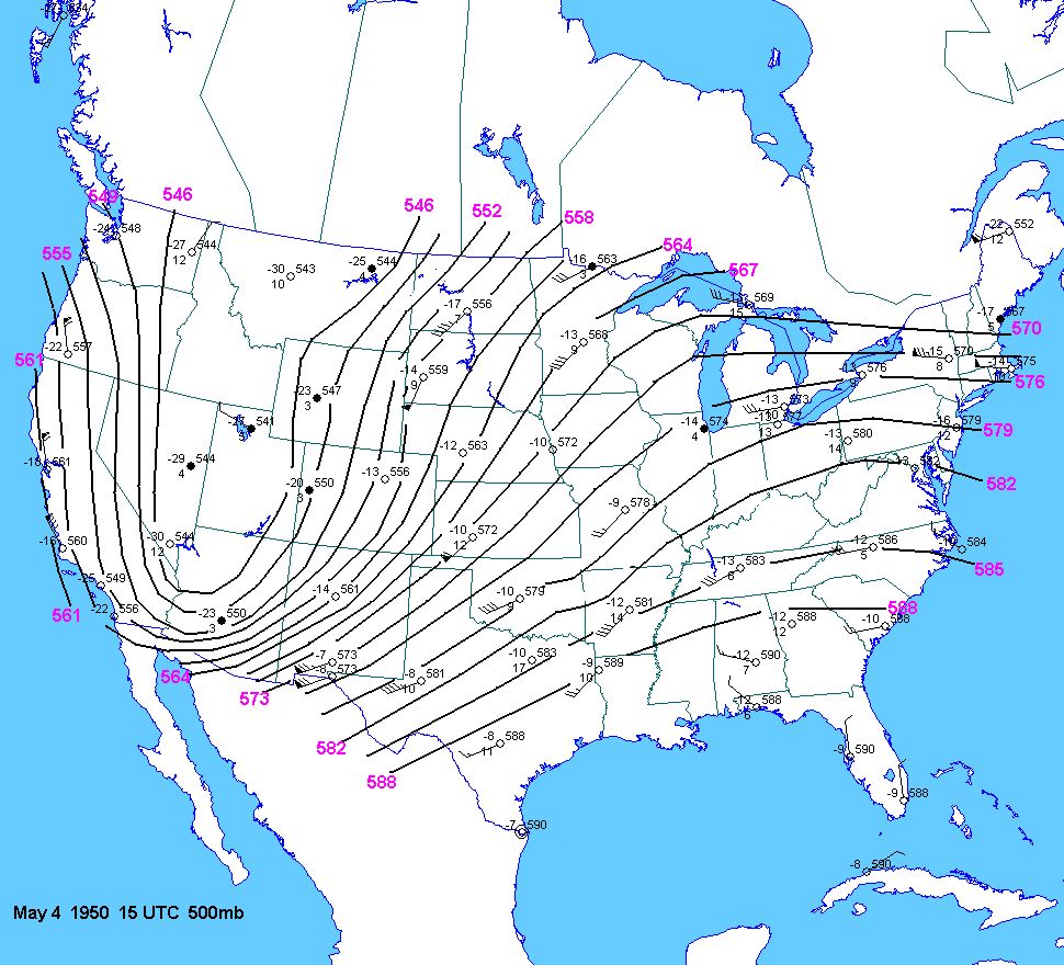
The 15 UTC May
4 500mb chart showed a deep trough over the southwest US with strong
flow across the plains states.
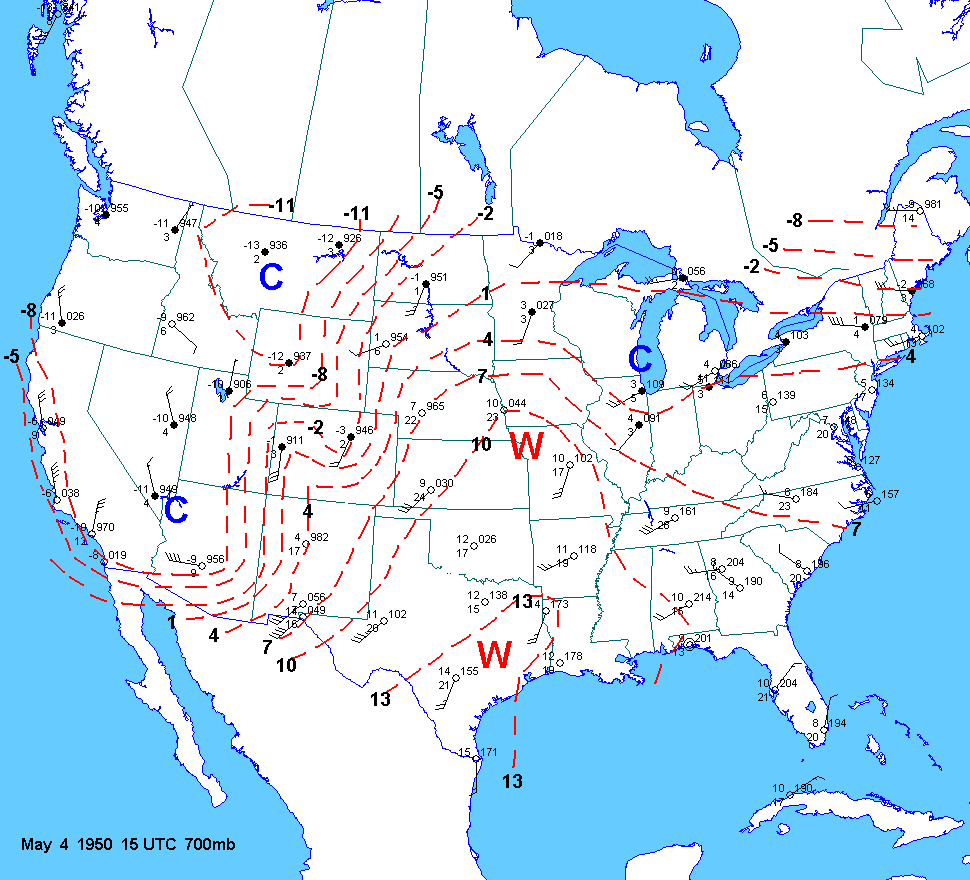
The 700mb
chart showed a tight baroclinic zone from NM/AZ into Colorado and Wyoming.
The 700mb 0C line stretched
from western NM to east of Denver to west
of Rapid City.
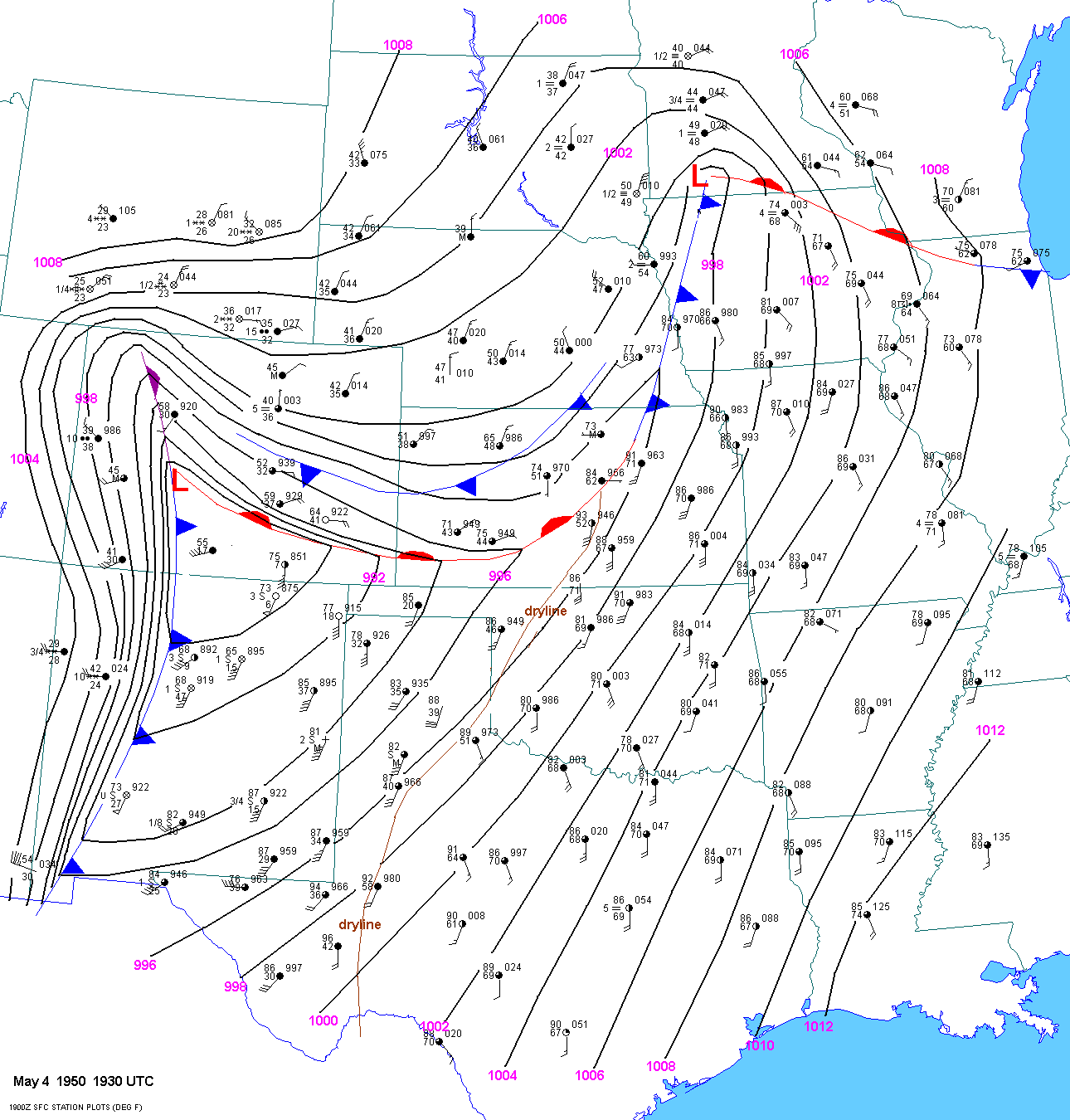
At 1930
UTC, a surface low(985mb) was located in southern CO with a warm front
east to southern Kansas. Keep in mind
that sea level pressure values can be
suspect at higher elevations. For example, the SLP was way out of whack at
places like
Alamosa, CO, Limon, CO and Colorado Springs for years. A cold
front stretched south from the low to west of Santa
Fe
and east of Rodeo, NM. The surface dryline extended
from just west of Midland, TX to just east of Lubbock to east of
Gage,
OK to just east of Hutchinson, KS. The cold front was
charging east around 45 to 53 mph.
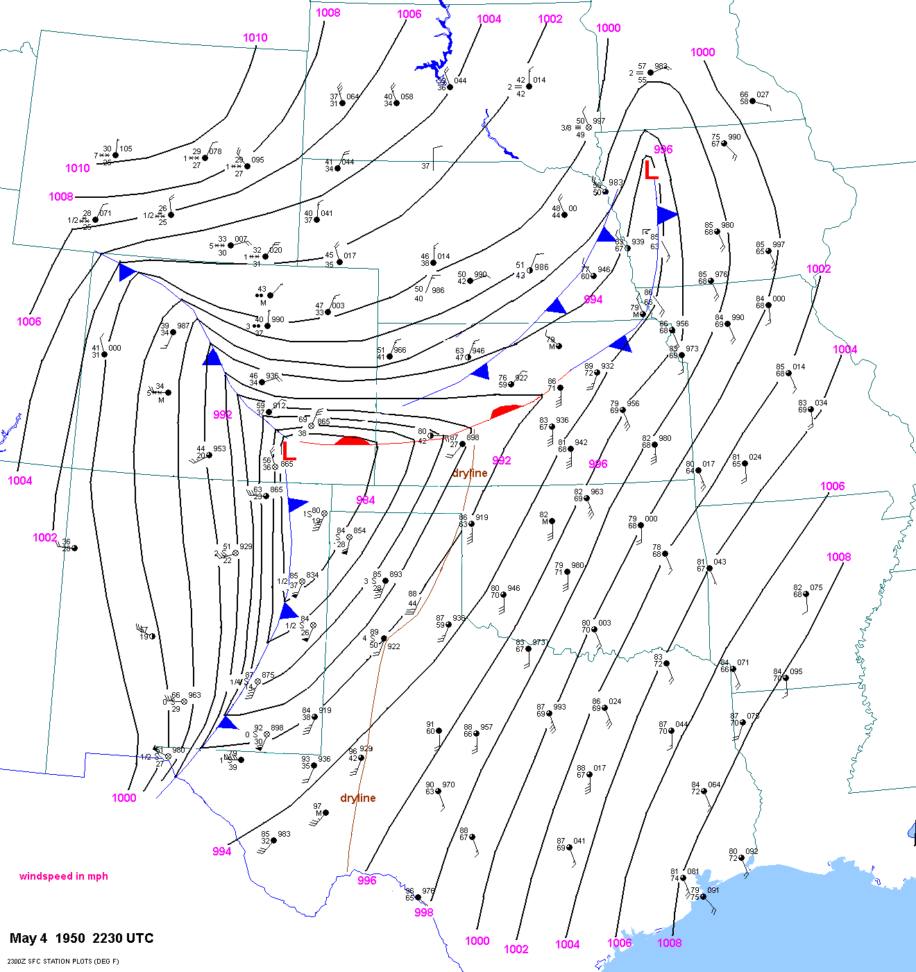
At
2230
UTC a strong "pacific" cold front was charging east into eastern NM. The
surface dryline stretched from east of
Dodge City to just east of Clarendon, TX
to east of Midland, TX. The northern end of the dryline was clearly
retreating
westward. The minimum pressure in the sfc low was about 984
ot 985 mb which was relatively unchanged from 1930
UTC. The cold front was
charging
east at 45 to 53 mph. This speed remained almost constant through the
afternoon and
evening hours as it moved into the Texas Panhandle and
western Oklahoma. The warm front was moving north over
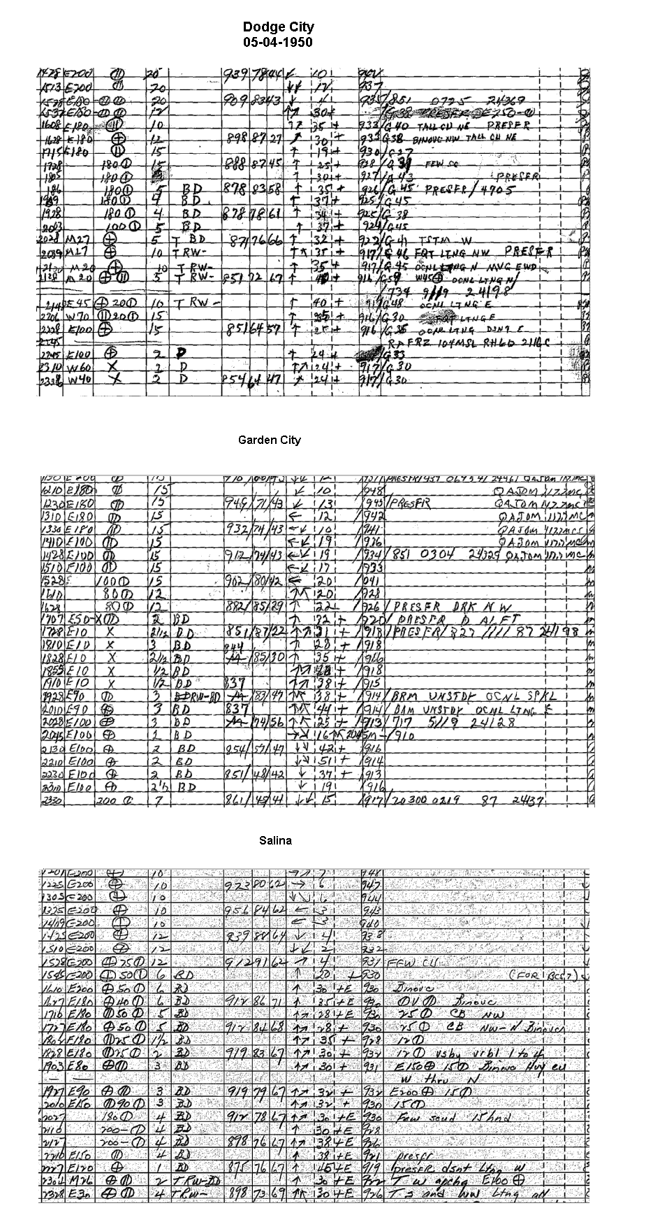
central and western
Kansas as can be seen in the surface observations from Dodge
City, Garden City and Salina.
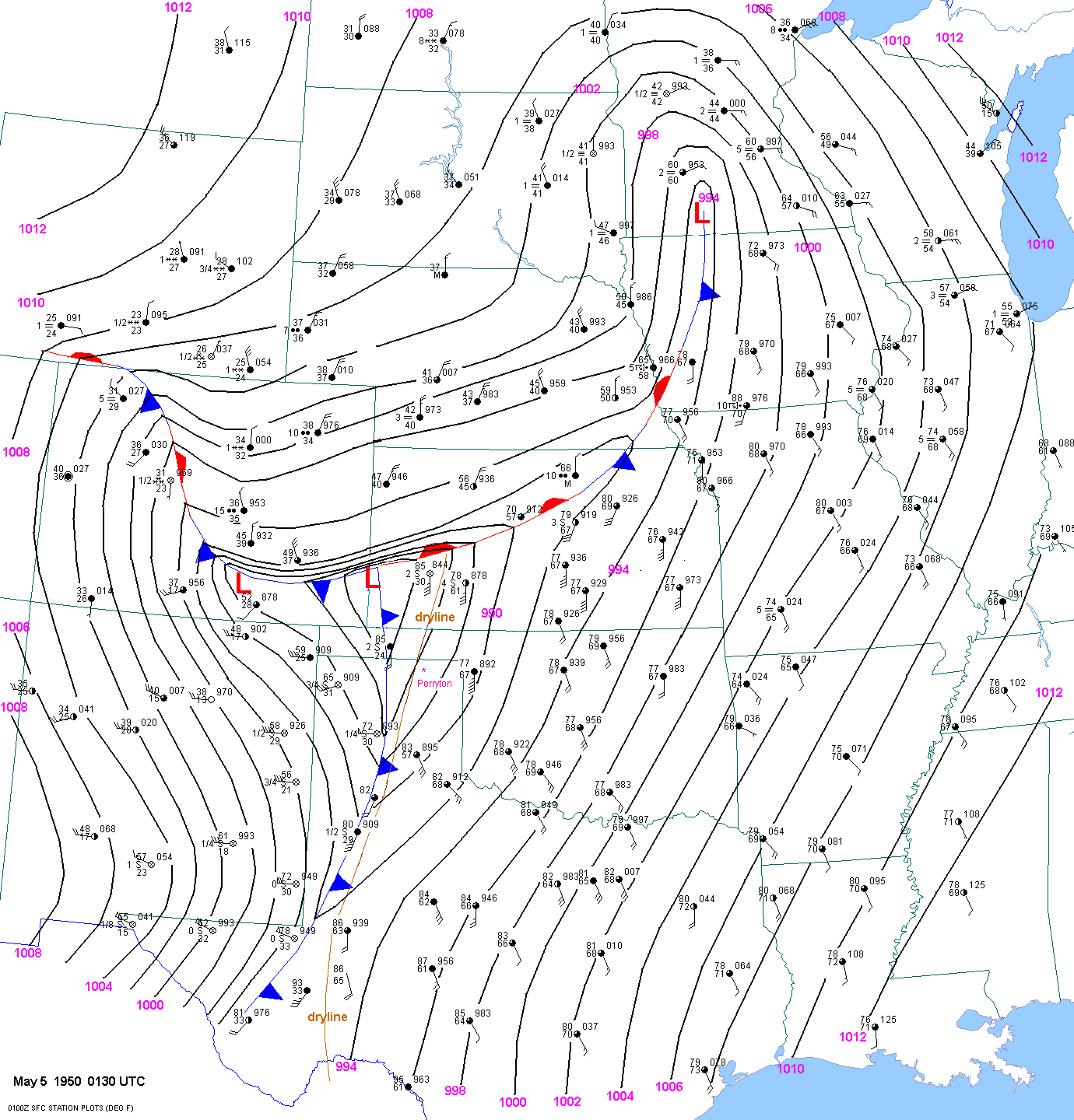
By 0130
UTC the minimum value of surface pressure was about 983 to 984mb in far
southwest Kansas. The surface
pacific cold front stretched south from
the low to just east of Amarillo to just west of Lubbock to east of Wink, TX.
The
dryline was still retreating westward and
stretched from west of Dodge City to west of Perryton, TX to just east of
Lubbock.
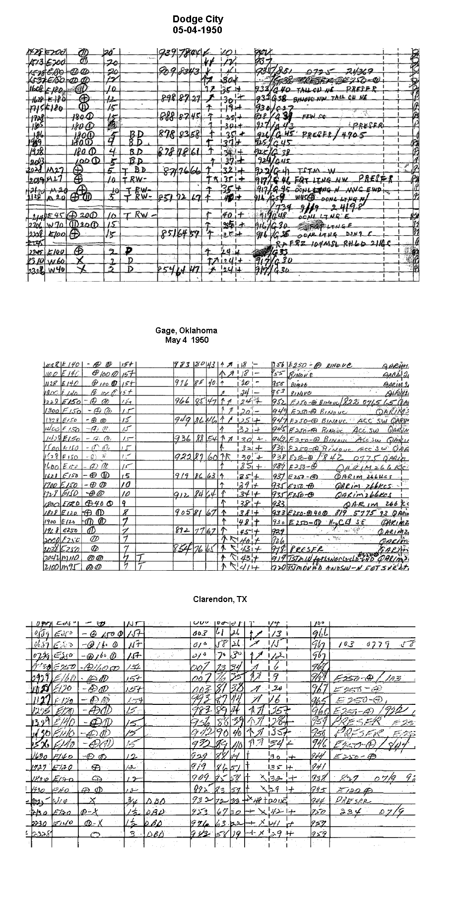
Surface observations from Gage,
Dodge City and Clarendon, TX show the retreating dryline. Note that the
cold front
had almost overtaken the dryline in west Texas and the
Texas panhandle. Snow was falling across Wyoming and the
front
range of
Colorado.
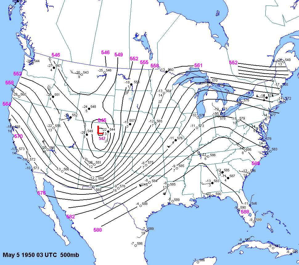
The 03 UTC
500mb chart showed an intense shortwave trough located
over the southern Rockies, with a lowest 500mb height
of 542dm over Colorado.
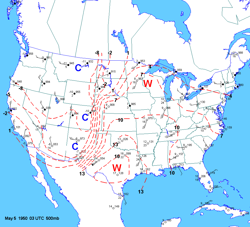
The 700mb chart showed the strong baroclinic zone marching eastward into
the Texas panhandle
behind the pacific cold front. 700mb
temps were very high by early May standards with +13C at Oklahoma City
and +16 at
Fort Worth.
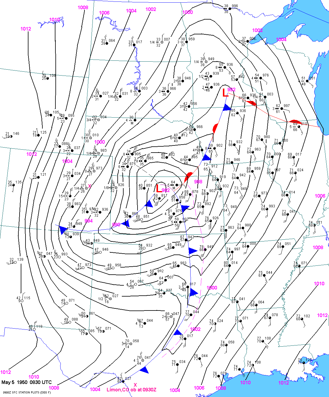
At 0830
UTC the surface low was down to about 981 mb with a trailing
pacific cold front into central OK and
north Texas. Blizzard conditions had
spread as far east as Goodland, KS. But it was still raining at North
Platte
and Hayes Center, NE. The rain-snow line extended almost due
north-south from Philip, SD to east of Goodland, KS.
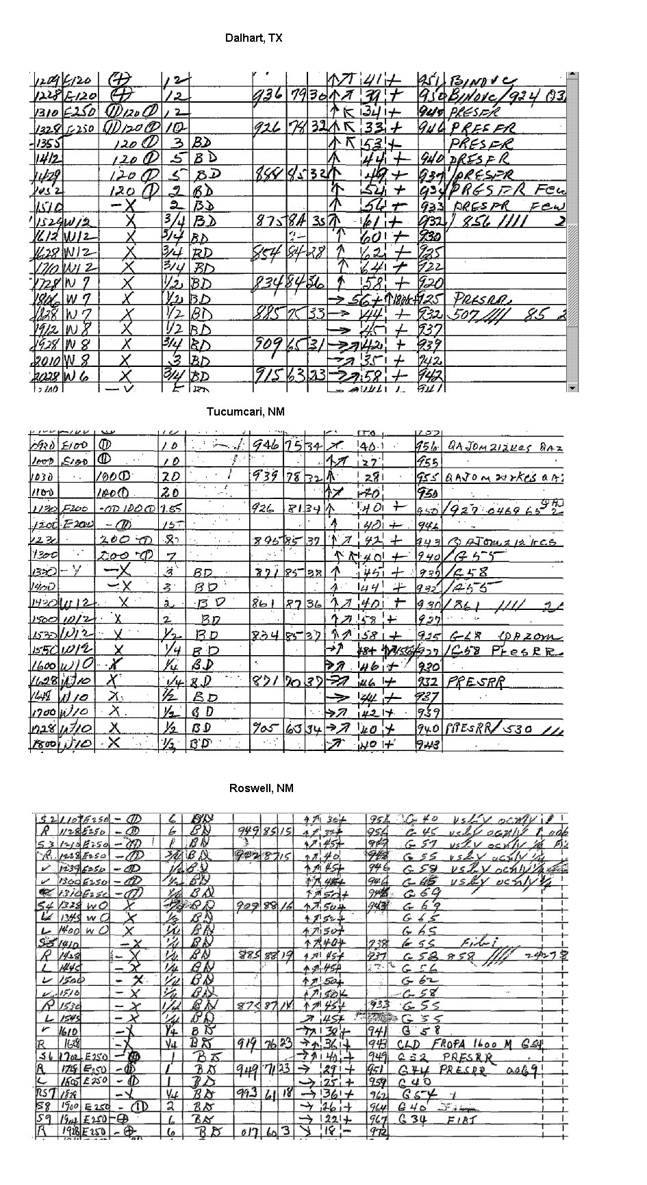
Duststorm
A duststorm occurred
during the afternoon and evening hours across eastern NM and west Texas. High
winds from
40 to 70 mph occurred well behind the dryline and ahead of
the pacific cold front, with visibilities as low as 1/4
mile.
Surface observations
from Dalhart, Tucumcari and Roswell demonstrate this. The worst part of the
duststorm, as is typical,
occurred behind a strong north-south
oriented pacific cold front. Surface
observations for several sites across
the
region show visibilities from a half
of a mile to near zero. Surface winds were as high as 50 to 60 mph. West
winds gusted
to 120 mph at Guadalupe Pass, TX.
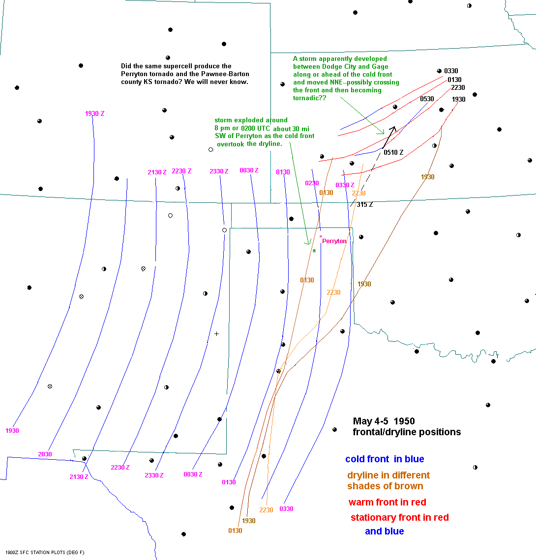
Tornadoes
A tornado cut a half-block
path through Perryton, TX around 830 pm. Several homes and a large warehouse
were
destroyed. I am trying to gather more details about this
strong tornado from local newspapers. "Significant
Tornadoes"
shows 1 fatality and 13 injuries with this tornado. The storm
that hit Perryton obviously developed southwest or
south-southwest of
town. Given that the dryline retreated
past Perryton around 730 pm and that the cold front
overtook Perryton
around 830 pm(around the time of the tornado), I am speculating that this
tornadic storm
developed as the cold front encountered the dryline southwest
of Perryton around 8 pm.
At 930 pm a tornado moved NNE from 3 miles west to 6 miles north of Carter in
Beckham county, OK. 20 farms were
hit. One home was destroyed on highway
34.
At 1110 pm a tornado moved NNE from Zook, Kansas in Pawnee county to 5 miles NW
of Great Bend. The path of this
tornado is shown here.
I estimated that the tornado moved North-25 deg E. 11 homes were destroyed near
Zook with
near F5 damage to 2 homes. 66 of the 100 units at Barton
Courts(northwest of Great Bend) were rendered unlivable.
Rural property damage
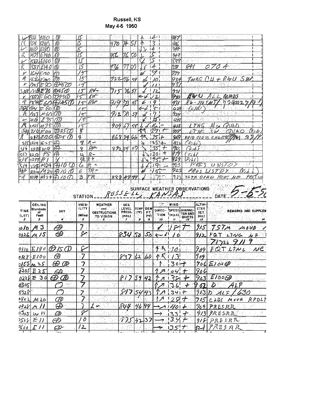
was greatest at "Ray" in eastern Pawnee county. Prior to this tornado,
thunderstorms moved across
Russell based on the
original surface observations from Russell. Gusty north winds and falling
temperatures occurred at
Russell
between 9 pm and 10 pm. Thus, it is likely that outflow from
storms north of Great Bend in the evening left out a
boundary(front
or outflow boundary). Storms either developed along this boundary and
became quickly tornadic or storms
developed when
the front met the dryline and eventually encountered the surface
boundary (becoming tornadic). The latter
scenario seems
more likely in my opinion. A map showing the position of the
front/outflow boundary that may have helped
cause this
violent tornado can be found here.
At 330 am, a tornado moved NNE from 2 miles N of Holton, KS and passed 2 N
of Whiting and 3 S of Hiawatha.
2 homes and 13 barns were destroyed.
Nine homes and 8 barns were damaged north of Whiting with all 5
injuries
occurring in this area.
These storms undoutbedly moved very rapidly to the NNE or NE at perhaps 50 to 60 mph.
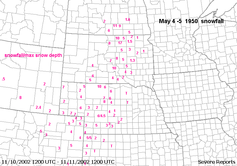
Blizzard
Blizzard to near blizzard conditions occurred from eastern Colorado, across far
northwest Kansas and into much
of central and western Nebraska, south
Dakota and North Dakota. Surface observations showing the
heavy
snow at several locations can be found here. A map of snowfall can be found here.
At least a 3 hour burst of
moderate to heavy snow occurred at Kearny,
NE(elev. 2200ft), with accumulating snow at Lexington, NE(2400ft).
This
is a rare occurrence this far south at such low elevations.
North Platte received 6 inches of snowfall with a max
snow depth of 4.5" due
to melting. 5 inches occurred at Hayes Center, NE. Goodland reported 4 inches of
snow.
The heaviest snow amounts occurred in Cherry, Brown and
Cheyenne counties in Nebraska, northward into
central SD and southern
ND. Another snowstorm occurred on May 6 but totals from this storm are not
included.
Some areas of SD/ND had 17 to 22 inches of snow from both of
these storms combined.
I called the
Des Moines Register and they were able to read me an article from the
paper concerning this windstorm. Here
are some
details:
Prelim
damage total was still being assessed and was in the millions
$200,000 damage to Iowa Power
and light system in DSM.
Trees fell and
smashed cars
Windows blown
out
many power
lines down.
flood lights
blown over at the Baseball park.
roofs blown off
lots of trees
down
chimney blown
off
drake univ
billboard blown down
a man
electrocuted in des moines
5th grader
killed when Cupola?? of a building fell on him
33 yr old
Madrid Grocer struck and killed by falling light tower at the baseball
field