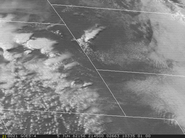
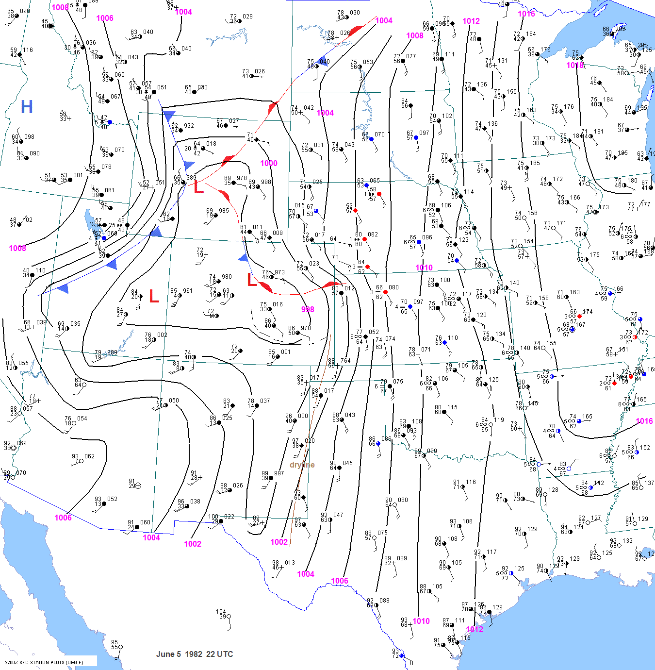
Severe Weather Case Study
June 5 1982


Jonathan D. Finch


Related items of interest

Historical Tornado Cases for the Cheyenne Warning Area


Detailed Tornado Cases for the Cheyenne Warning Area      

Historical Tornado Cases for the Boulder Warning Area

Historical Tornado Cases for the United States

Elevated Mixed Layer

Elevated Heating

High plains and front range topo maps


Severe Weather Occurrences

                               
                                        Isolated severe thunderstorms occurred on June 4, 1982.  A few tornadoes were reported in the Nebraska panhandle
                                        from 1 thunderstorm. Elsewhere, there was a 1-inch hail report in northwest South Dakota,  1 golfball sized hail report
                                       in western Tennessee and 1 tornado report in southeast Oklahoma.

                                        On June 5, Wyoming, western South  Dakota and the Texas panhandle experienced severe weather. Storm chase
                                        crews went to western Nebraska, western Kansas and the Texas panhandle. Al Moller decided to storm chase in the
                                        Texas panhandle. GOES east satellite loops for Wyoming and the Texas panhandle as well as the GOES west loop
                                       for Wyoming are all very impressive. The GOES east loop over Wyoming will take a while to load for those with slow
                                        internet speeds. I plan to create an alternate version with fewer frames.

                                        The most damaging thunderstorm on the northern high plains appears to have developed southeast of Shirley Basin near
                                        the border of Converse and Albany counties around 2245 UTC. This storm produced damaging tornadoes in Converse
                                        and Niobrara counties in Wyoming and Fall River county in South Dakota. Storm data mentioned that a tornado struck
                                        15 miles southwest of Douglas at the Red Canyon Ranch at 0125 UTC. The Red Canyon Ranch is non-existent today.
                                        I called the library and several town offices in Douglas and noone had heard of the Red Canyon Ranch. I decided to
                                        obtain the actual newspaper article from the June 10, 1982 edition of the Douglas Budget in hopes of determining the
                                        exact location of the tornado. The article did provide some useful information and featured a photo of a funnel cloud
                                        near Douglas. Buildings were demolished 15 miles west-southwest of Douglas around 510 pm MST. I was able to
                                        pinpoint the exact location of this tornado by contacting people mentioned in the newspaper article. Robert Cross and
                                        the former Converse county emergency manager Bill Meehan helped tremendously. The demolished buildings were
                                        at the Red Canyon Ranch. This ranch in 1982 was located on Spring Canyon Road about 1 mile south of Windy
                                        Ridge road along Red Canyon Creek. The elevation was of the ranch was about 5700ft. An 85 year old rancher woman
                                        named Minna Cross was critically injured as she "stepped out of a barn building just before the tornado turned it into
                                        woodscraps". Several other buildings were damaged. Cottonwood trees were snapped off. The total damage from this
                                        tornado was $30,000-40,000. The surface observation sheet from Casper indicated that this tornado lasted from 510 pm
                                        MST to 527 pm. Storm data documented the starting time of this tornado at 0125 UTC. As already mentioned, the
                                        surface observations sheet from Casper has a 0010 UTC starting time.

                                        There is some descrepancy on where the 2nd tornado touched down. The observation sheet from Casper indicated this
                                        tornado occurred 3 miles northwest of Douglas at 604 pm. Storm data also shows this tornado northwest of Douglas.
                                        However, the "Douglas Budget" indicated that the tornado hit 3 miles northeast of Douglas on county road 52, destroying
                                        Gayle Major's mobile home. She was thrown from the mobile home but escaped injury. This tornado may have been                
                                        caused by the same storm that produced the Red Canyon Ranch tornado. It is unclear whether this same storm continued
                                        into Niobrara county, or whether another storm developed near Douglas and moved east-northeast.

                                        At 720 pm MST, a severe storm hit Lance Creek with a 2 mile by 4 mile wide swath of golfball to tennis ball sized hail. At
                                       730 pm MST, a tornado apparently developed 2 miles west of the junction of highways 270 and 85, or about 5
                                        miles east of Lance Creek. A mobile home and barn were destroyed and a farm house was damaged. This tornado tore
                                        down 1 mile of power lines and blew cars and pickups off the highway. Antelope were killed. Only minor injuries to
                                        humans were reported. No damage was reported in eastern Niobrara county.  Storm data indicated a 1 mile path length
                                        for this tornado in Lance Creek. But the tornado did not hit Lance Creek.

                                        As this storm moved into South Dakota, a tornado touched down just across the border in South Dakota or about 6 miles
                                        miles southwest of Igloo. Part of a roof was town off a house. Two pickup trucks, one pulling a horse trailer, were
                                        thrown into a fence. 2X6 timbers were driven into the side of a house. A barn was moved 17 feet then destroyed. All
                                        of the surrounding corrals were destroyed. A missing stock tank was found 6 miles away at Igloo. Six power poles
                                        were downed on the west side of Igloo. One minor injury was sustained from flying glass. The tornado moved across
                                        the rural community of Igloo at 830 pm MST. Twenty to 30 empty railroad coal cars were blown on their sides.The
                                        end of 2 buildings at the Beef Palace were torn off in Igloo. A mile east of Igloo at Provo, the tornado destroyed a
                                        small building, twisted another off it's foundation and turned over a travel trailer. Several outbuildings were demolished
                                        and there were numerous reports of roof damage. This storm continued moving east-northeast to the Angostura Reservoir
                                        and into northeast and eastern Fall River county. Golfball to baseball sized hail broke numerous windows and windshields.
                                        Mobile homes were dented by the hail and holes were knocked in cabin roofs. High winds and hail broke several windows
                                        at the Hot Springs airport. Baseball sized hail also fell in extreme eastern Fall River county or 11 miles east of Smithwick.
                                        Wheat and rye crops were totally devastasted from Haverick south to near Oelrichs and in the Horsehead area. Alfalfa
                                        was also flattened. This storm likely moved into wide open Badlands in Shannon county where no damage was reported.
                                        Golfball sized hail occurred near Pierre between 0710 and 0730 UTC. Perhaps this was the same storm that continued
                                        moving east-northeast? If so, then the storm must have accelerated from 35 mph to over 40 mph after producing tornadoes
                                        in Fall River county.

                                        It is obvious to me that severe weather was much more continuous than indicated in storm data on this day in Wyoming.
                                        However, the sparse population and the fact that severe reports were not sought after in the 1970s and 1980s lead to
                                        very few reports. For some reason, the SPC storm database shows no hail reports in Wyoming on this day. However,                   
                                        the final storm data indicated tennis ball sized hail near Lance Creek. Needless to say, very large hail likely occurred                     
                                        from the Douglas area east-northeast into southwest South Dakota.

                                        A tornado was repoted over Casper mountain from 758 to 801 pm MST. Storm data states that this tornado occurred
                                        from 701 pm to 710 pm MST. No other information was available on this storm. Perhaps the Casper Tribune mentioned
                                       this storm?

                                        A storm that initiated off the east side of the Bighorn mountains moved northeast or east-northeast across Johnson,
                                        Campbell, Weston and Crook counties in Wyoming and as well as Lawrence and Butte counties in South Dakota. This
                                        storm undoubtedly produced lots of severe weather. The only severe weather reported along this path was near the very
                                        end of the path in southern Butte county. But the time listed for this event in storm data is 0500-0530 UTC. This does
                                        not match the time that satellite showed the storm moving into the county. So was there another storm after the initial storm                 
                                        that moved into Butte county?  Baseball sized hail covered the ground at Nisland and Arpan. Some of these stones were
                                        jagged and 7 inches across. The hail and wind damaged everything in the storm path, breaking windows, wrecking roofs,
                                        stripping trees and cropland, killing sheep and straying large herds of cattle. Lightning strikes ripped apart huge trees.                             
                                        Storms exploded in the western Texas Panhandle. Al Moller decided to chase storms in this area. His account from this
                                        day includes sketches of  the tornadoes as well as actual tornado damage and effects. The storm data description of this                    
                                        tornado was rather wordy but not very informative. According to Moller, "Both of these tornadoes missed Borger, but the
                                        2nd one caused $300,000 at the Phillips Petroleum and injured 2 employees to the west. Also, a car was blown off of
                                        state highway 136 west of Borger and a man was critically injured in the auto." "The hail in west Borger was up to softball
                                        size causing $5 million damage."  There were only 3 severe weather reports for this big severe weather event. Of course,
                                        severe storm reports were not sought after in the 1970s and 1980s. Also, the storm was likely over very rural areas
                                        prior to moving into the Borger area.                      


Meteorological Discussion   
                                                                           

                  June 4

                                        At 12 UTC, a 500mb trough was located over the western United States. A shortwave trough was moving across
                                        Missouri and Arkansas. The 250mb chart showed a jet from the southern plains into the northeast and another from
                                        central CA into northern Utah. A warm plume over the Rockies separated cold air at 850mb along the west coast
                                        from cool air over the plains. 700mb temperatures were very cold along the west coast.                                      
                                                    
                                        At 18 UTC on June 4, a cold front was pushing across Wyoming and Utah. A cold front was also pushing through the
                                        southern plains and southeast and extended from Memphis to Monroe, LA to San Antonio. Cool surface high pressure
                                        extended from Kansas into north Texas.                             
                                     
                                        By 21 UTC, the Texas cold front was becoming stationary around San Antonio but was still progressing southeast
                                        through east Texas and Louisiana. The weak, northern Rockies cold front was still progressing eastward. By 00 UTC
                                        this front was about to move through Miles City, MT and was through Douglas, WY.

                                        The 00 UTC 500mb chart still showed a deep trough centered over northern CA. The shortwave trough that was
                                       centered over Missouri and Arkansas at 12 UTC was progressing off to the east.
The 850mb  chart showed rich
                                        moisture in central and south Texas.
 With the 500mb ridge over the central plains and west-southwest flow from Arizona
                                        into west Texas, one would expect lee troughing and northward moisture transport over west Texas to begin. There was
                                        also a 10C dewpoint at North Platte at 00 UTC. This was not due to the incipient southern high plains moisture surge,
                                        but was "residual moisture" from the plain's cool and rather moist airmass already in place. This moist layer at
                                        North Platte was only about 60 mb deep though. Rich, deep moisture was in place at Del Rio.
                                        
                                        Strong 700mb warming occurred during the day over the southern and central Rockies, with 11-13C temperatures by
                                        00 UTC. Of course, part of this warming was diurnal. A 850mb warm plume was located over the Rockies. So why did
                                        I analyze 850mb temperatures over the Rockies since 850mb is underground there? Well, I took the temperature at the
                                        nose of the low level inversion on the Rockies' soundings down the dry adiabat to 850mb. This actually gives Plain's                
                                        forecasters an idea of what 850mb temperatures could be if strong downslope develops.

                                        By 03 UTC, the northern Rockie's front was moving across the northern plains and approaching Glendive, MT where
                                        thunderstorm was reported. This front was not yet through Laramie.

                                        By 06 UTC (11 pm MST June 4) the front was approaching Williston, ND, where a shower was in progress, and was
                                        approaching Cheyenne. As expected from the 00 UTC UA charts, northward moisture transport was occurring over
                                        west Texas with a 64F dewpoint at Midland and 60F at Lubbock.                                   


June 5
                               
                                   
                                        The evolution of surface features was complicated on June 5. For example, it was very difficult to track the weak cold
                                        front in the northern plains and central Rockies. The frontal appears to be stalled by morning. But this could be due to
                                        diurnal pressure rises ahead of the front. Does this boundary become stationary during the day, move to the west as a
                                        warm front or undergo frontolysis?  The southern front on June 4 appears to be moving toward the Gulf Coast and
                                        banked up against the Rockies. By June 5, it becomes nearly impossible to track the southern front. Also, the portion of
                                        the front banked up against the Rockies seems to push east and transition into a dryline by the afternoon of June 5.                       
                                        Perhaps frontolysis occurred with this front and ceased to exist by June 5. On the morning of June 5, cool  air was still in
                                        place from Oklahoma north into the northern plains. Strong return flow brought ample moisture north into this cool airmass,
                                        serving to reinforce the cool airmass. As a result, there appears to be a baroclinic zone from southern Oklahoma into the
                                        eastern Texas panhandle during the day. Whether this thermal gradient constitutes a front is probably more of an artistic
                                        arguement than anything else. The important thing is that the forecaster is aware of such features.  A surface trough
                                        developed in southeast Colorado during the day, causing backed surface winds at La Junta and Pueblo. This trough
                                        limited the northern extent of the surface dryline. A southeast Colorado surface trough is a common occurrence and is  
                                        related to the terrain.
                                                                   
                                        By 09 UTC June 5, the northern plains front was passing through Brandon, Manitoba and extended to the south-southwest
                                        through Rapid City to near Denver, CO. The surface dewpoint was up to 61F at Clovis and 62F at Lubbock.

                                        The 12 UTC 250mb chart showed the main jet stream of 110 kts over Salt Lake City and Ely, NV. However, part of
                                        this jet branched off into the southern plains and deep south. The 500mb chart showed a weak shortwave trough moving
                                        northeast across the northern Rockies and northern plains. This wave was probably responsible for the weak cold
                                        frontal passage through Cheyenne, Denver and Rapid City. As we suspected, strong moisture advection was occurring
                                        overnight at 850mb. The moisture on the North Platte sounding was not very rich yet, but had deepened considerably
                                        Much richer moisture was present on the 12 UTC Dodge City sounding. The 850mb dewpoints at Amarillo and Midland
                                        had increased to 16 and 17C respectively. Although this moisture was very rich, it was not all that deep.
                     
                                        The 12 UTC surface chart showed a 61F dewpoint as far north as Dalhart, TX. The southern surface front was still
                                        stationary near San Antonio. The front that sagged south into Colorado overnight was difficult to find since radiational                   
                                        cooling had occurred ahead of the front. 


By 15 UTC, the surface moist axis was located from the Texas panhandle into far western Kansas. Based on the
                                        surface observations, the cold front was apparently still pushing south through Colorado, but it was not through Pueblo
                                        and La Junta yet. The northern part of the front was still located from west of Bismark to near Rapid City.

                                        By 17 UTC the front that had been moving through Colorado had stalled. the front did not appear to pass through
                                        La Junta and Pueblo despite the east winds at those locations. I analyzed a trough line south of these stations. It is very
                                        common to get east or southeast winds up the Arkansas River valley but that doesn't necessarily mean that a front has
                                        passed. The dewpoint at Douglas jumped from 35 to 47F from 15 to 17 UTC. But was this moisture deep? Dewpoints
                                        were up to 60F as far north as Goodland, KS and Champion, NE.

                                        By 18 UTC, the front in Colorado had pulled up stationary. This boundary was actually surging north as a warm front
                                        in Wyoming. I still analyzed a trough line south of La Junta and Pueblo. The surface dryline was becoming well defined
                                        south of this trough.

                                        The shallow moisture that appeared at Douglas, WY was already mixing out by 19 UTC. But surface winds in the
                                        Nebraska panhandle were strenghtening from the east-southeast, advecting moisture into far eastern Wyoming. Locations
                                        such as Rawlins, Rock Springs and Craig were already mixed out at local noon and this is typical of stations above
                                        6000ft. The 1915 UTC visible shot over Wyoming shows some convection developing from west of Laramie to southwest
                                        of Douglas.

                                        By 20 UTC the dewpoints at Rapid City, Chadron and Scottsbluff were up to 56F. But the dewpoint at Douglas, WY
                                        was still 39F. This is surprising given the southeast winds all morning. It is possible that the dewpoint at Douglas is in error
                                        The 1945 UTC visible shot shows surface based cumulus developing south of Glendo Reservoir and near Laramie Peak.

                                        The 20 UTC satellite picture over the southern high plains showed a few small cumulus in the clear areas to the east and
                                        south of Dalhart. The 2026 UTC southern plains visible picture  indicated 2 areas of cumulus. One was south of Dalhart
                                        and the other to the east. At 2041 UTC, the cumulus to the south of Dalhart in Oldham county seems to be bigger. The                     
                                        2050 UTC  visible shot shows this area of cumulus still growing. Also, notice how the clouds change suddenly from
                                        cumuliform in southwest Oklahoma to stable wave clouds in northwest Oklahoma and southwest Kansas. 

                                        The 21 UTC surface map shows continued moisture return into eastern Wyoming. The 2045 UTC satellite shot still
                                        indicated cumulus development south of the Glendo Reservoir and near Laramie Peak. Thunderstorms had already
                                        developed over the Bighorn mountains northwest of Casper. Between 2100 and 2130 UTC, a thunderstorm rapidly
                                        developed in the Midwest, Sussex, North Butte area.  A thunderstorm was also devleoping over the Black Hills.

                                        Thunderstorms started to initiate in southeast Wyoming around 2145 UTC. The first cells appeared to develop from
                                        south of the Glendo Reservoir and near Laramie Peak.

                                        In the southern plains the surface winds have backed at Elkhart where the dewpoint jumped from 57 to 64F in 1 hour.               
                                        Also the winds were veered at Dalhart and backed at Amarillo. So the dryline seems to have sharpened in the far
                                        western Texas panhandle. The 2053 UTC satellite shot shows an even larger cumulus south of Dalhart in Oldham                     
                                        county.  There was explosive convective development between 2100 and 2130 UTC to the east or southeast of
                                        Dalhart. Other convective clouds were rapidly developing between Amarillo and Clovis. At 2144 UTC, a towering
                                        cumulus can be seen west or southwest of Amarillo ahead of the surface dryline, or about half way between Amarillo
                                        and Tucumcari.

                                        The 22 UTC surface chart still showed backed winds from the south-southeast at Amarillo, with the surface dryline in
                                        the same location. The convective cloud west of Amarillo was still developing rapidly. The initial thunderstorm that
                                        developed raced off to the northeast.

                                        The dewpoint at Laramie jumped from 39F at 21 UTC to 44F at 22 UTC. The surface dewpoint at Gillette is likely
                                        much too low. Also, it is very uncommon for the dewpoint at Cheyenne and Laramie to exceed the dewpoint at Douglas
                                        in strong upslope flow cases. At 22 UTC, several storms were in progress across Johnson, Campbell, Big Horn and
                                        Washakie counties. By 2215 UTC, thunderstorms had developed southwest and west of the Glendo Reservoir and
                                        in northern Albany county to the southwest of Laramie Peak. By 2245 UTC, as the initial cells were moving off to the
                                        northeast and about to weaken, more storms were developing further west due to advection of higher dewpoints onto
                                        the high terrain. One cell in particular was rapidly developing along a stationary front along the Albany-Carbon county
                                        line. It takes a special pattern to get low level moisture advecting over the Cheyenne Ridge onto the high country of
                                        southern Wyoming. But it is obvious from the 2245 UTC visible shot that this storm developed southwest of the                                 
                                        Laramie range. The elevation in this area is about 7500ft.

                                        The following table shows the important contribution of elevated heating to equivalent potential temperature over the 
                                        high terrain. The temperature/dewpoint at Laramie were only 61F/44F compared to 73F/63F at Emporia, KS. Even
                                        though the T/TD were 12F/19F higher respectively at Emporia, the theta-e was about the same at the 2 locations. The
                                        44F dewpoint at Laramie has about the same amount of moisture as a 51F dewpoint at Emporia. So on a "level playing
                                        field", the dewpoint was about 12F higher at Emporia. The potential temperature at Laramie was 101.5F, compared
                                        to 77.8F at Emporia. So despite the mixing ratio being 61% higher at Emporia, the theta-e was about the same at the 
                                        two locations since the potential temperature was 24F higher at Laramie.
                        
22 UTC Elev(ft) Pres.(mb) T(F) Td(F) MR(g/kg) theta(F) theta-e(K)
Laramie   7270 769.3 61 44 8.0 101.5 336.8
Douglas 4900 839.0 69 43 7.1 96.2 330.8
Emporia 1208 969.1 73 63 12.9 77.8 336.3


                                        Surface based, deep convection was imminent to the north-northwest of Laramie a 22 UTC. Convection was trying to
                                        fire between Laramie and Douglas by 2215 UTC. The GOES east visible shot also shows this at 2214 UTC.
                                      
                                        But then, a thunderstorm developed about 40 miles southwest of Douglas along the Albany-Carbon county border
                                        southeast of Shirley Basin between 2215 and 2245 UTC. This is the storm that produced a tornado at Red Canyon
                                        Ranch at 0010 UTC.


                                        Surface based, deep convection was imminent to the north-northwest of Laramie a 22 UTC. To get an idea of how
                                        much instability was present in this area, I will use a method of computing liftex that to my knowledge has only
                                        been used by myself. Let's take the surface temperature at several stations in the dry air across southern Wyoming
                                        and western Colorado from 18 to 20 UTC (after mixout) up the dry adiabat to 700mb and then 500mb and document
                                        the temperature at those levels. This will give us an idea of the low to mid level thermal profile in the dry air. With
                                        moderate 500mb flow from the southwest, we can assume that stations to the northeast of these will experience similar
                                        500mb temperatures. Then we will take the surface temperature and dewpoint at stations in the moist air up to the
                                        lifted condensation level and then up the moist adiabat to 500mb. Subtracting this temperature from the former
                                        temperature (environmental temperature) will give us the lifted index in the moist air.
Using the above information,
                                        along with the T/Td at Laramie at 22-23 UTC, yields a surface based lifted index of -7.                                 


20 UTC Elev(ft) Alt  Pres.(mb) SLP(mb) T(F) Pot. T (F) 700mb T 500mb T
Rawlins
6813 23.15 783.9 1000 68
106 10.6 -15.3
Rock Springs 6760 23.14 783.5 66.5 104.4 9.8 -16.2
Craig 6193 800 998.0 71 105.9 10.6 -15.3
Eagle 6540 23.38 791.6 998.0 75 110.3 13 -12.9
Grand Junction 4858 24.83 840.7 998.5 80 107.4 11.3 -14.0
Alamosa 7539 22.66 767.3 70-73 113.1 13.6 -12.3
Aspen 7820 760 70 112.0 14 -12.0


                                        The 
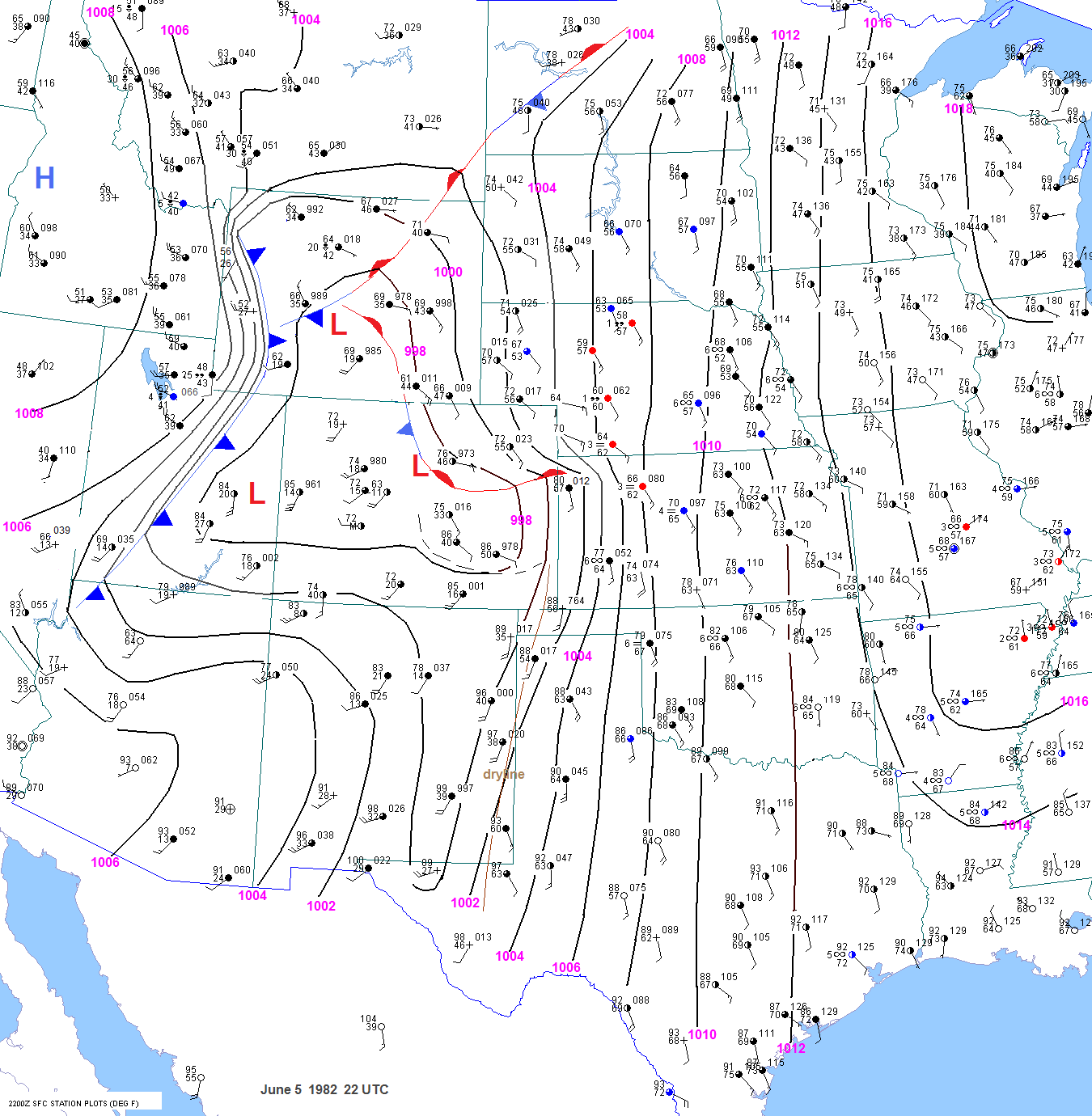
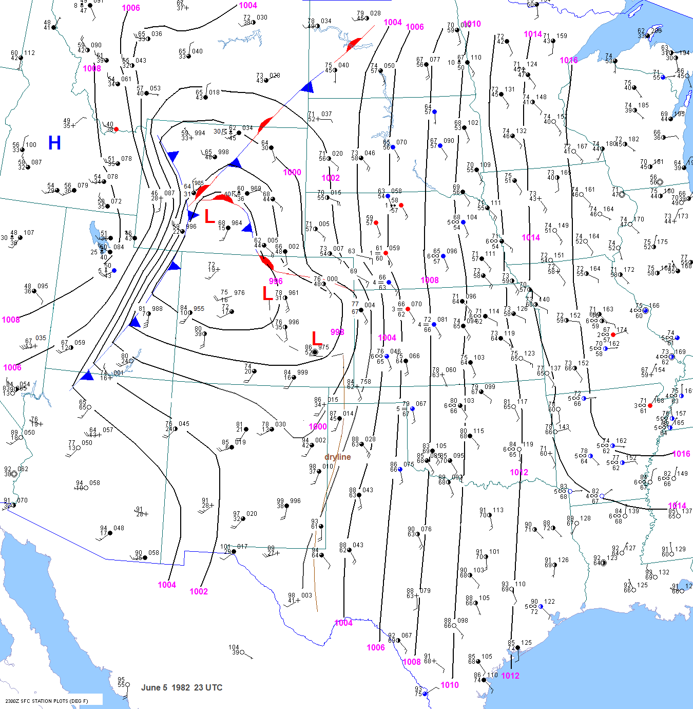
23 UTC surface chart still indicated a strong moisture influx into eastern Wyoming. The
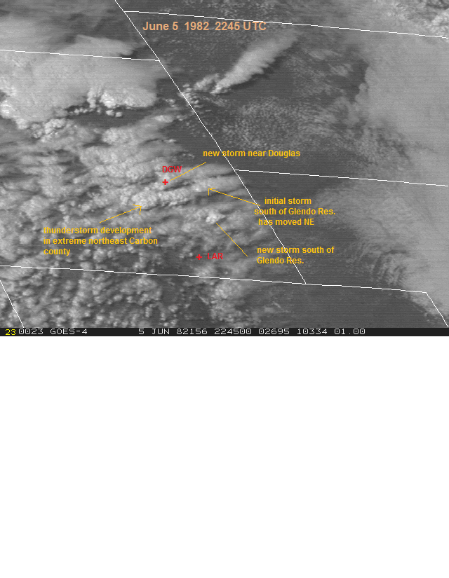
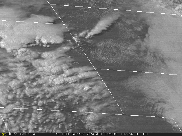
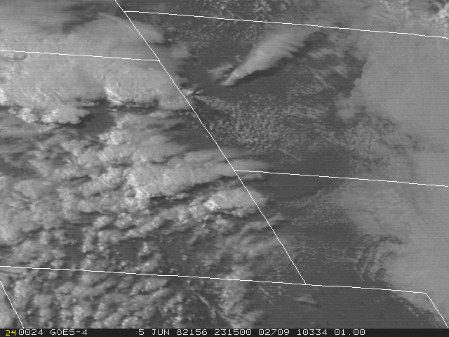
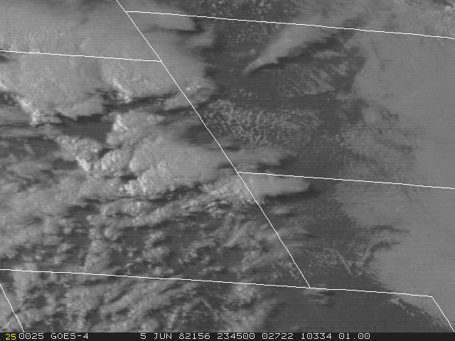
 2315 and 2345 UTC visible
                                        shots 
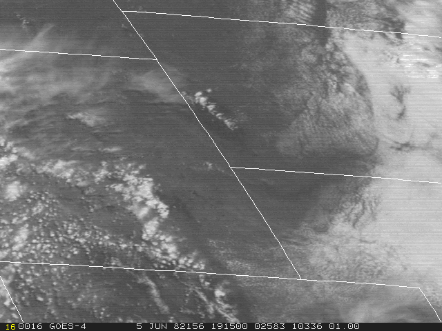
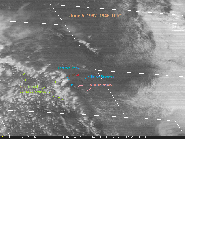
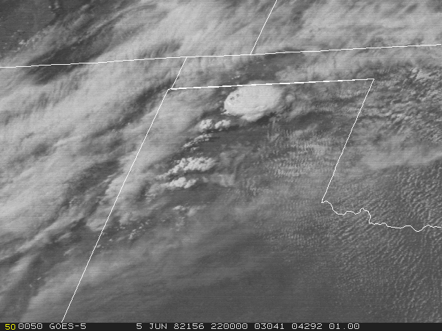
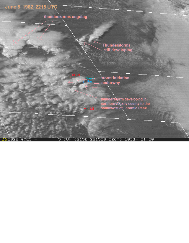
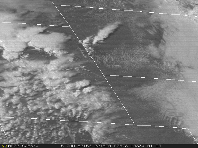
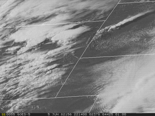
shows continued storm development over southwest Converse county. The storm that initiated near the Albany
                                        Carbon county line appeared to be over the Laramie mountains by 2315 UTC and on the lee side of the Laramie
                                        mountains by 2345 UTC. By 0015 UTC, when the first 
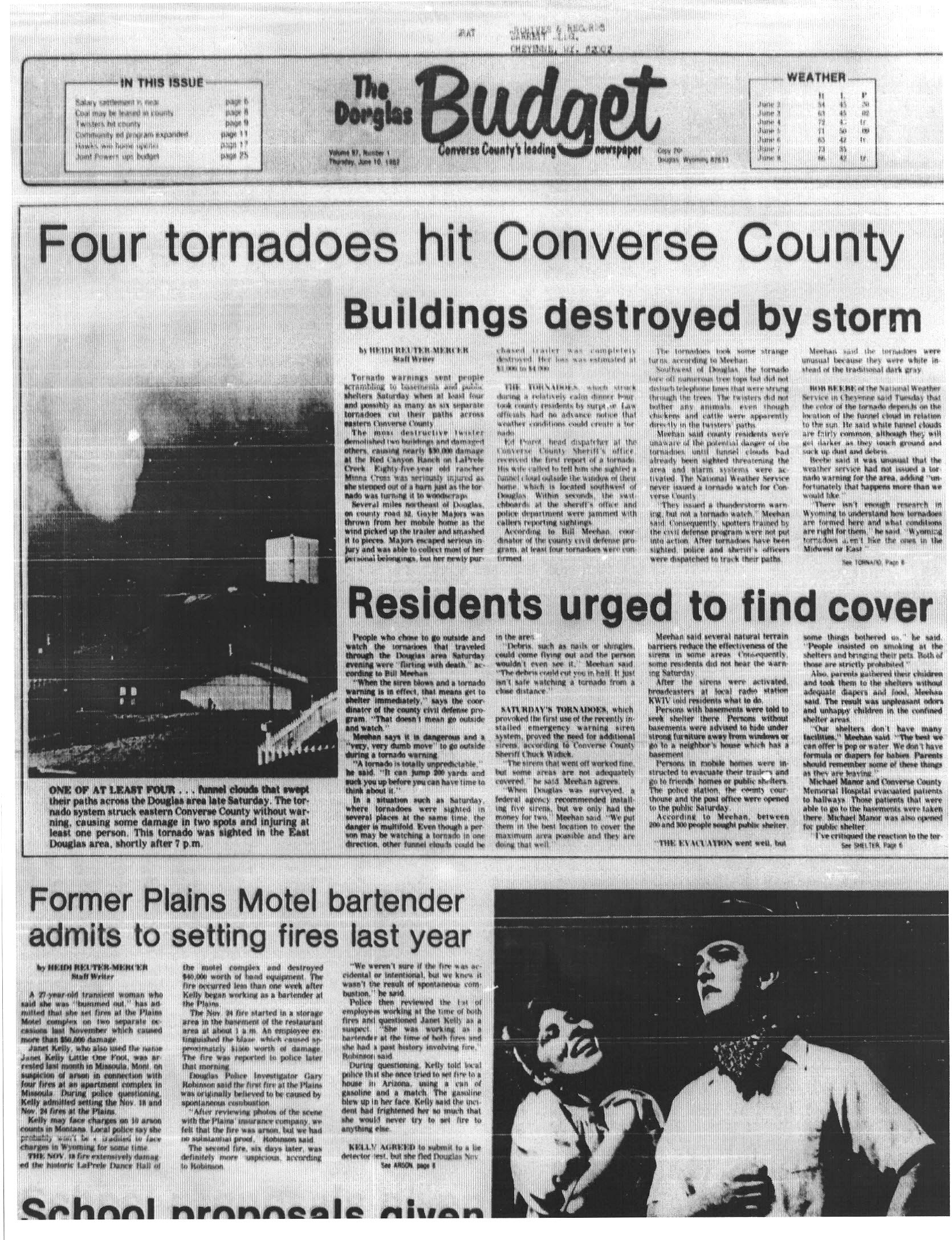
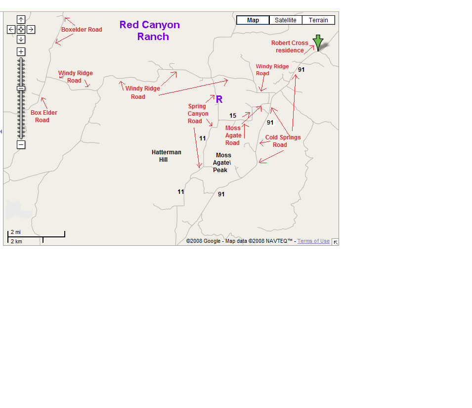
tornado was in progress after initially touching down at the Red
                                        Canyon Ranch, the visible shot shows 2 overshooting tops over Converse county, one to the northeast and one further
                                        southwest. There was also development on the flank. This cluster of storms moved through the Douglas area and produced
                                        a damaging tornado at 0104 UTC 3 miles northeast of Douglas. Other smaller storm cells were also developing back
                                        along the surface boundary in Carbon and northwest Albany counties. Of particular note was a cell  that initiated over
                                        west central Albany county at 0015 UTC. This cell moved northeast into the Douglas area around 0145 UTC. The storms
                                        that caused the tornadoes at Red Canyon Ranch and near Douglas moved east-northeast and caused high-end severe
                                        weather in Niobrara county. Again, it is difficult to assess whether one particular cell was responsible for all the tornadic
                                        activity or not due to the multiple storms.

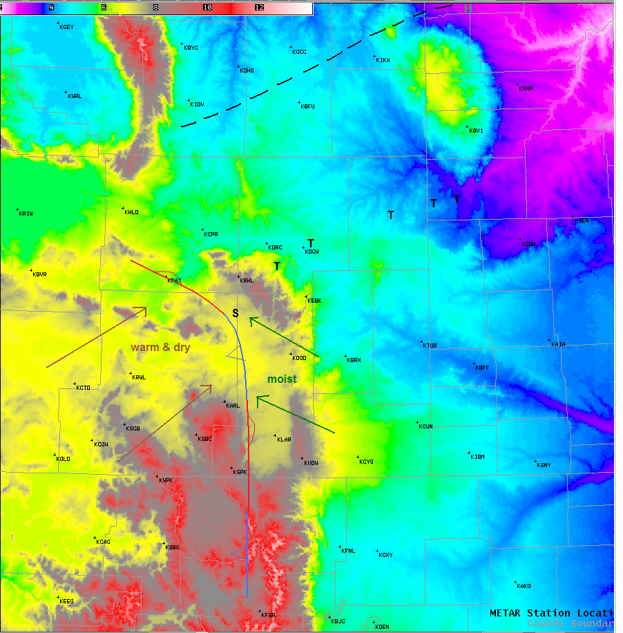
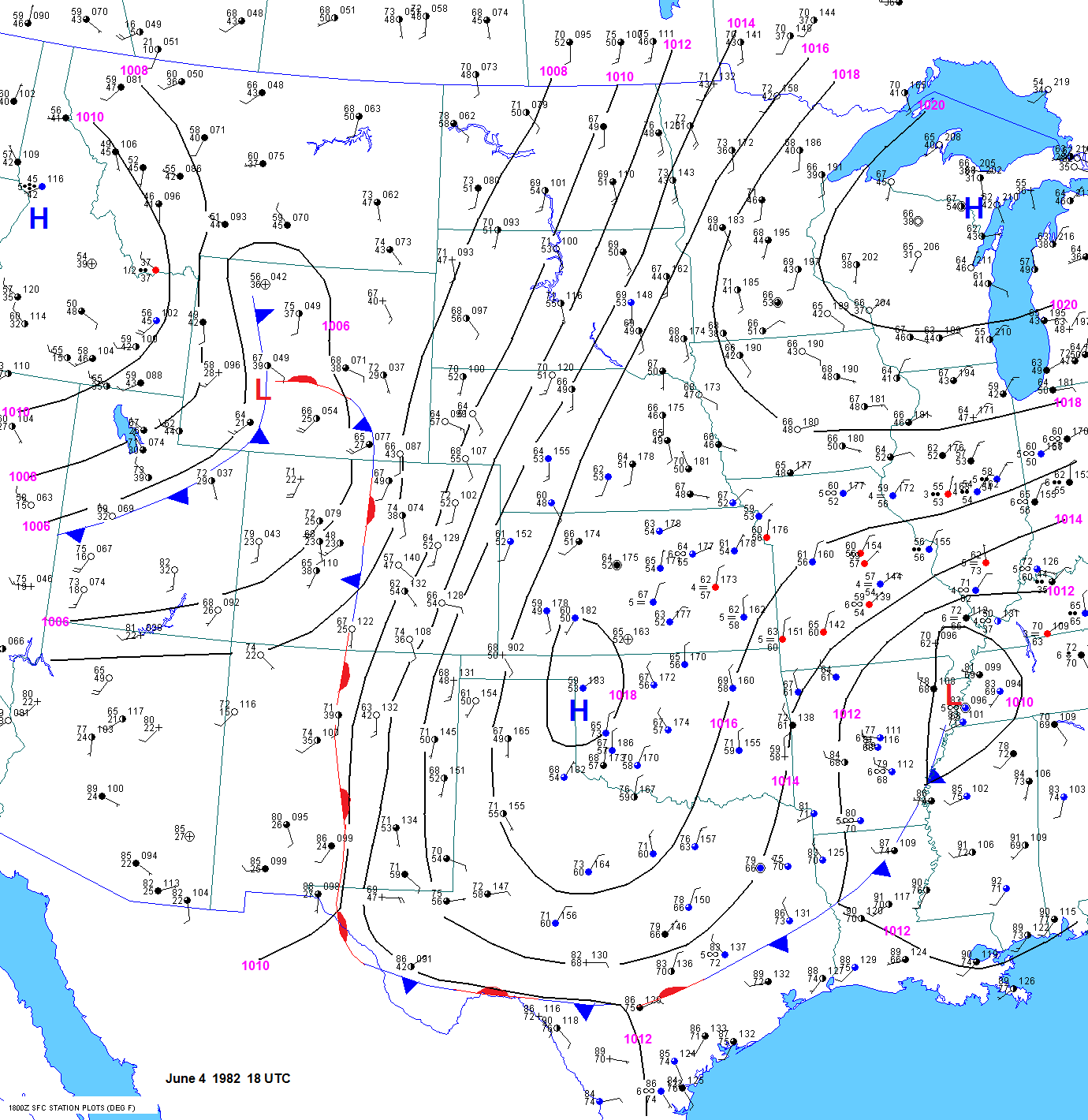
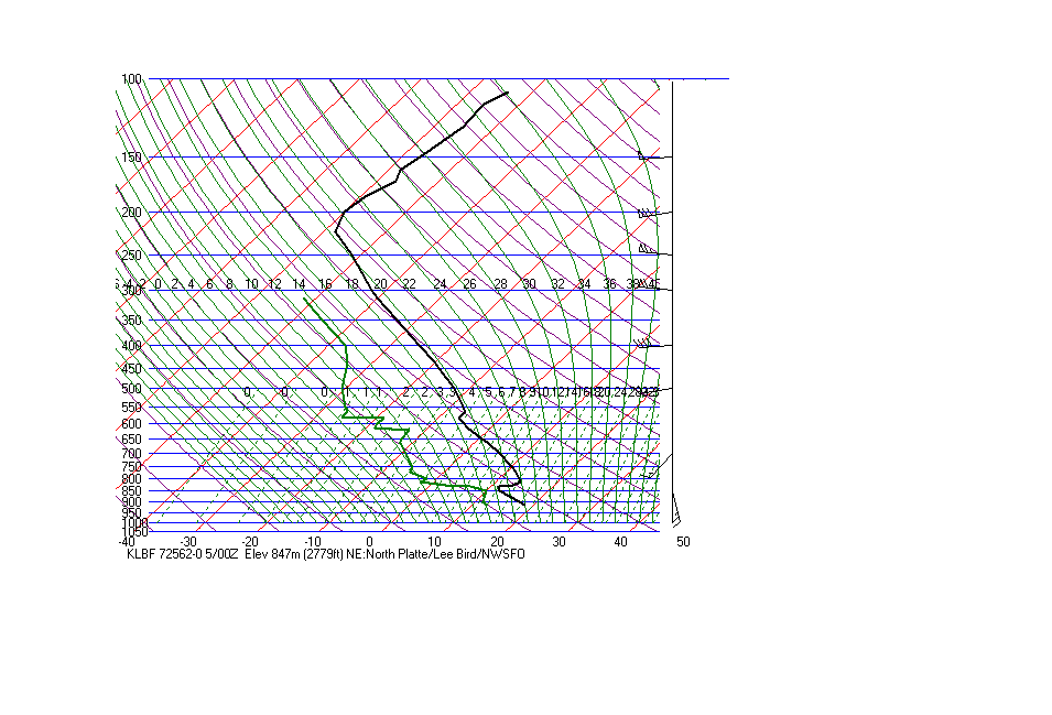
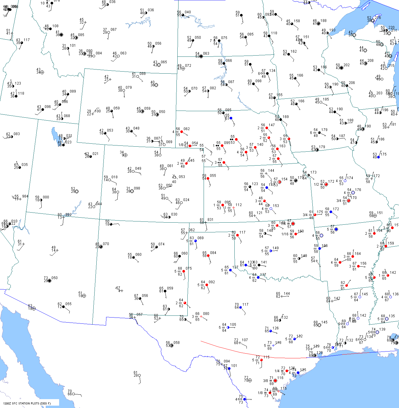
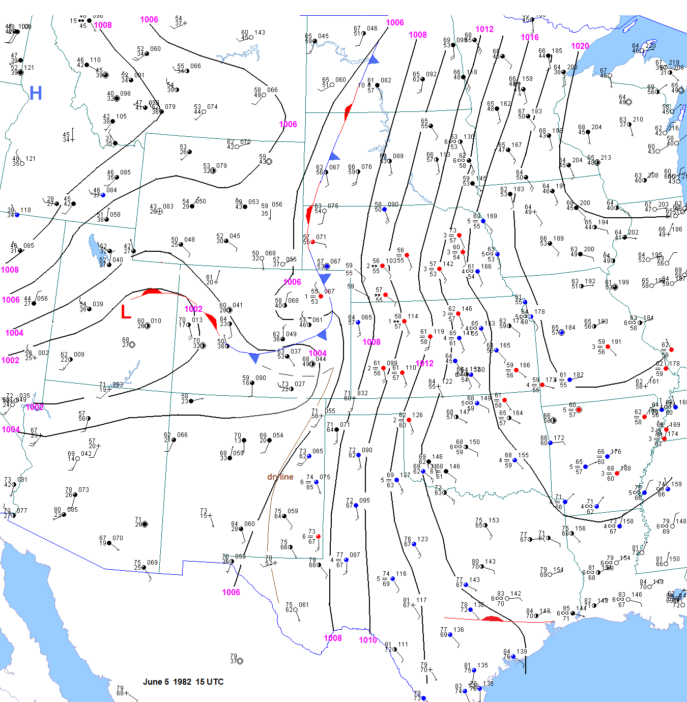
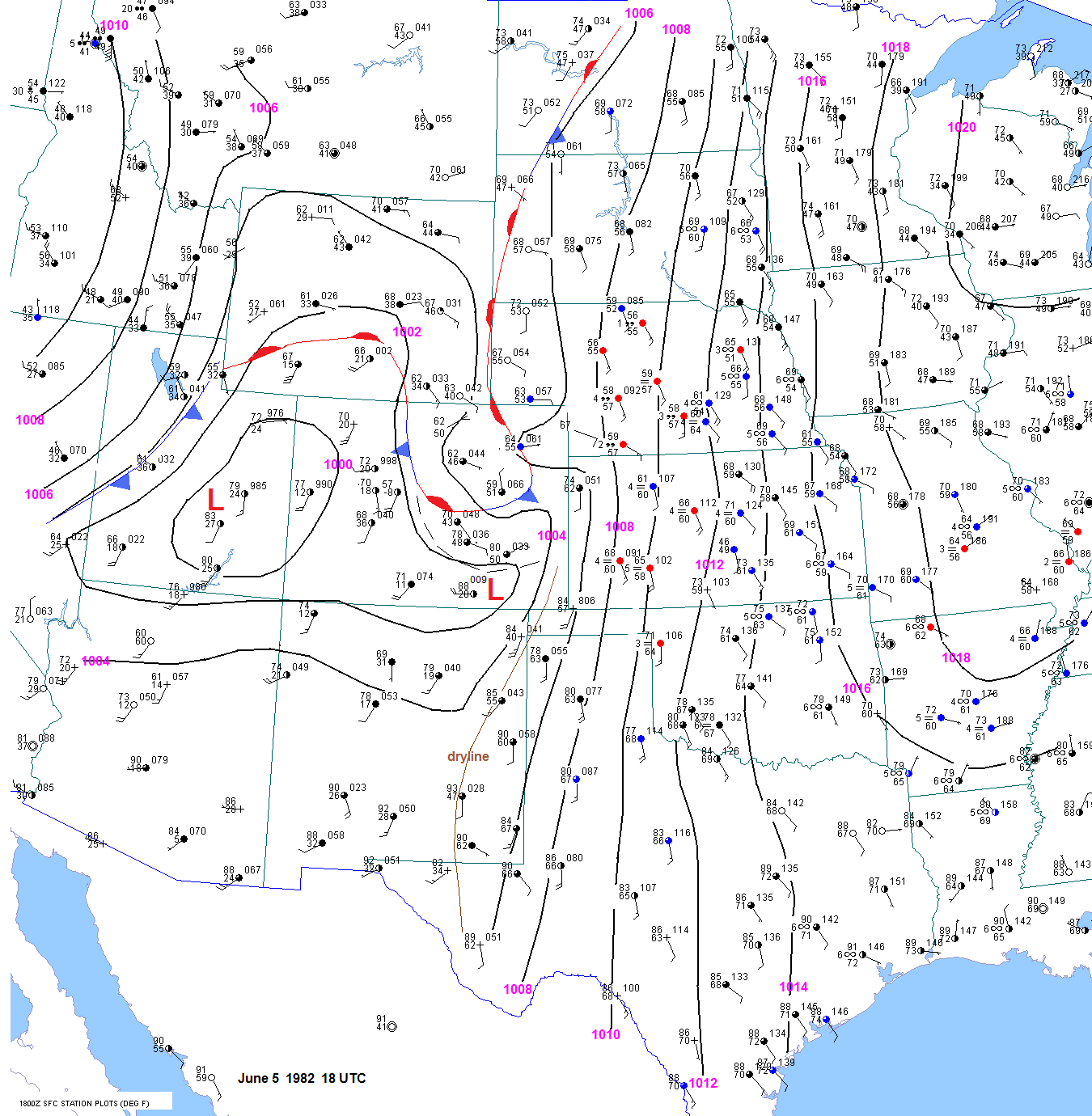
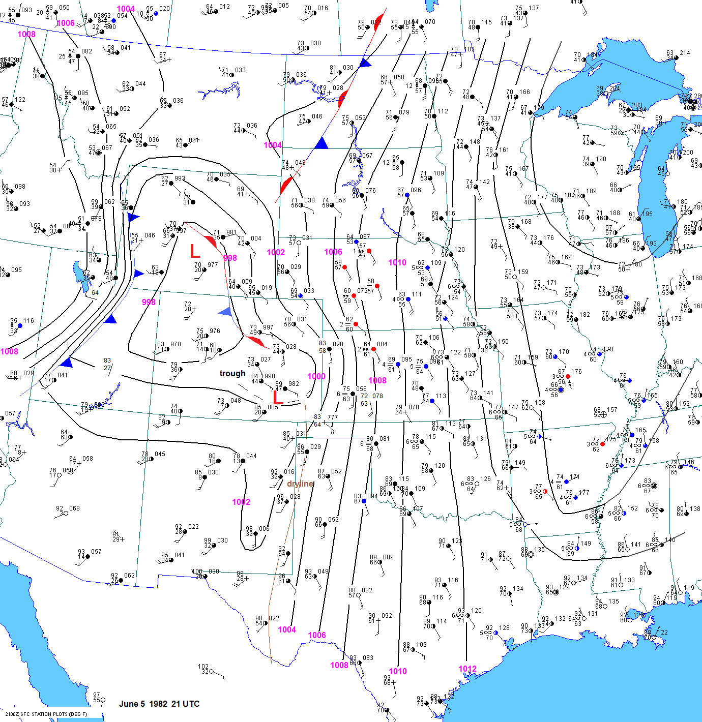
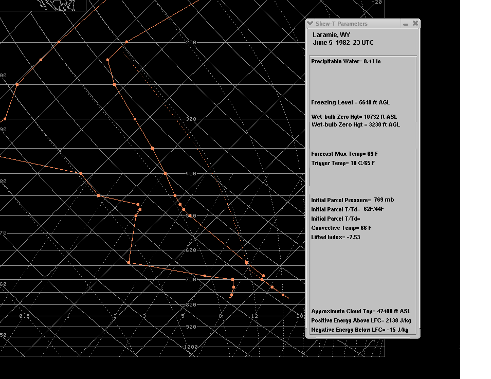
                                        Using the surface observation at Laramie at 23 UTC along with the 00 UTC raobs, the surface based CAPE near the
                                        front in southeast Wyoming was around 2100 j/kg. Surface observations from Douglas indicate much lower theta-e values
                                        compared to Laramie. The surface based CAPE using the observations from Douglas would be only 500 j/kg. I still think        
                                        that the dewpoint values at Douglas were off by 5 to 12F. It just does not make sense for the dewpoint to be so low at
                                        Douglas despite hours and hours of moisture return up the Platte River valley. Experience indicates that in such a surface
                                        pattern, dewpoints at Douglas are not too far below the values at Scottsbluff. The vertical wind shear was very strong, with
                                        southeast low level winds and 60kt 400mb winds from the southeast. This yields 0-6 km shear values over 60kts.                                          
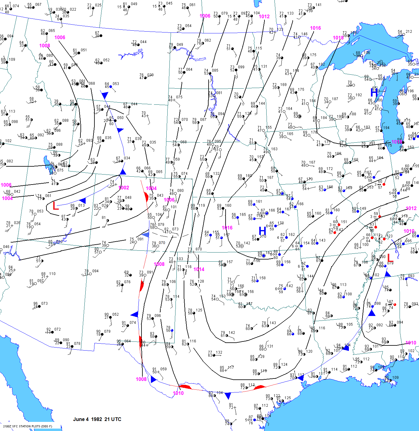
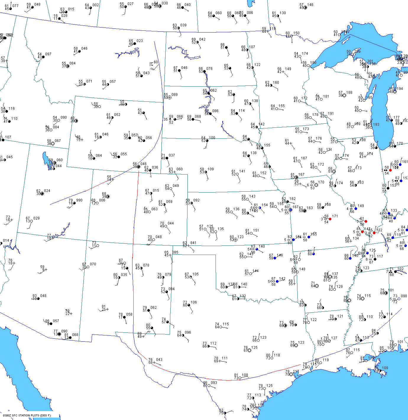
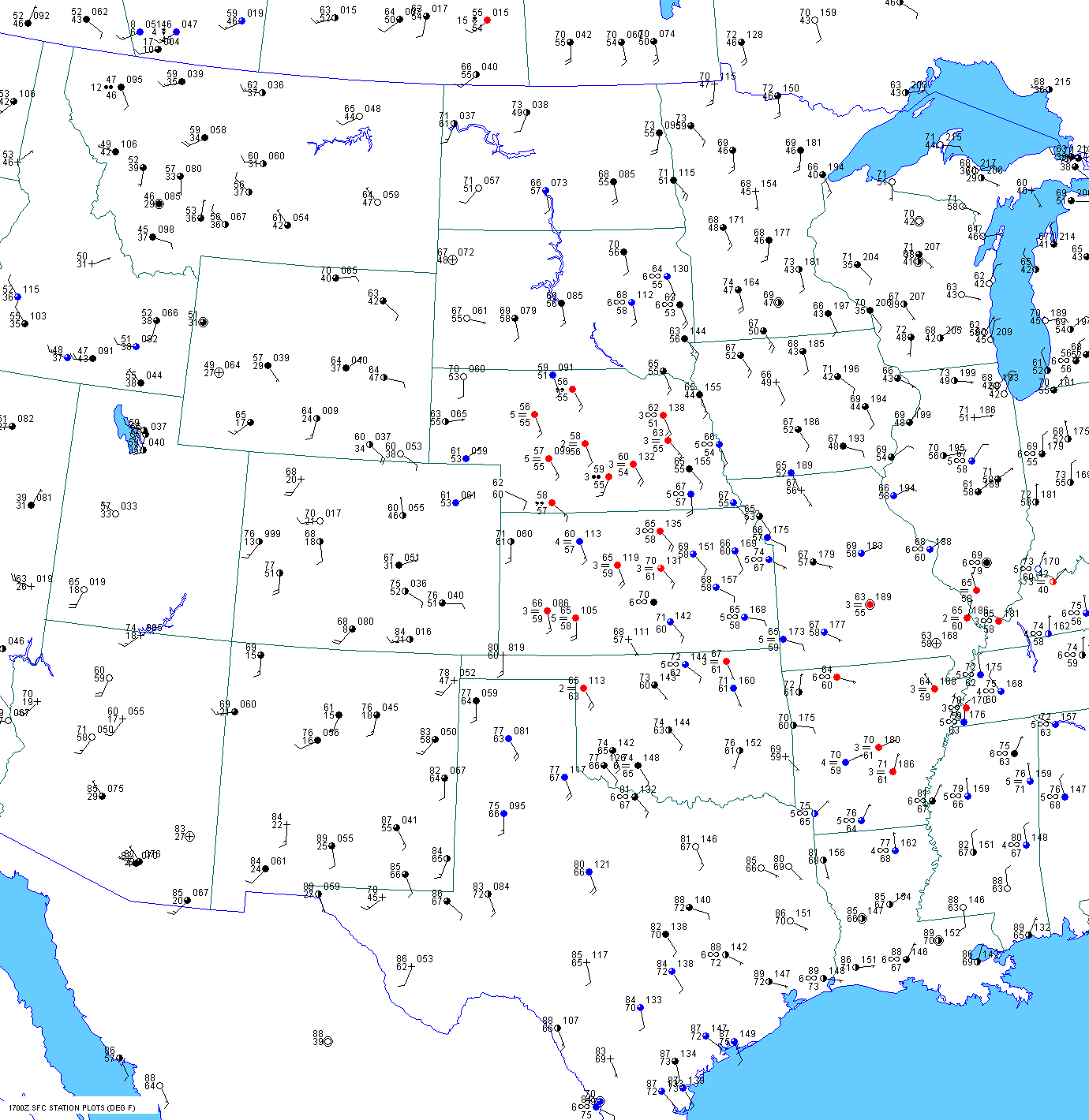
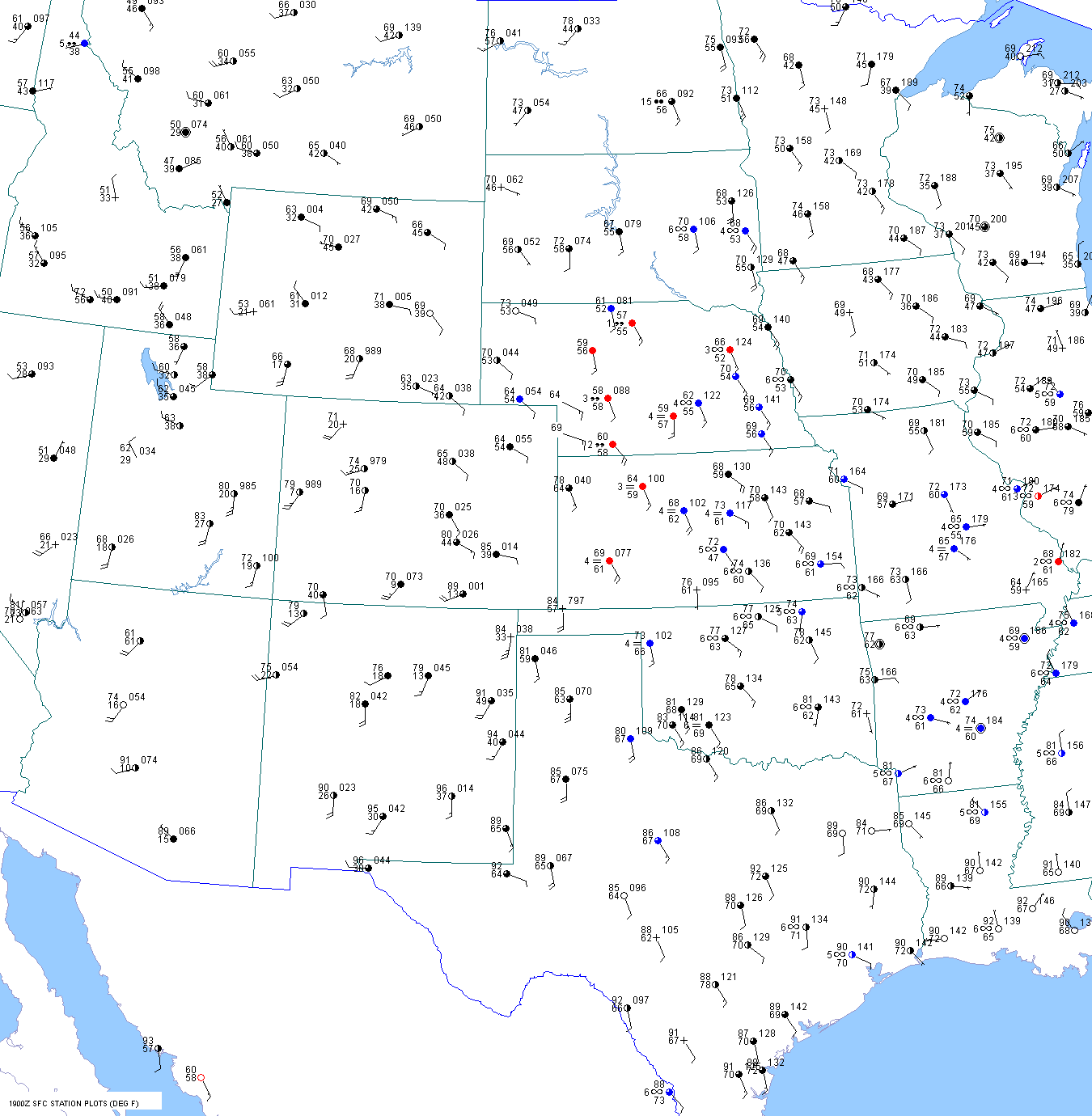
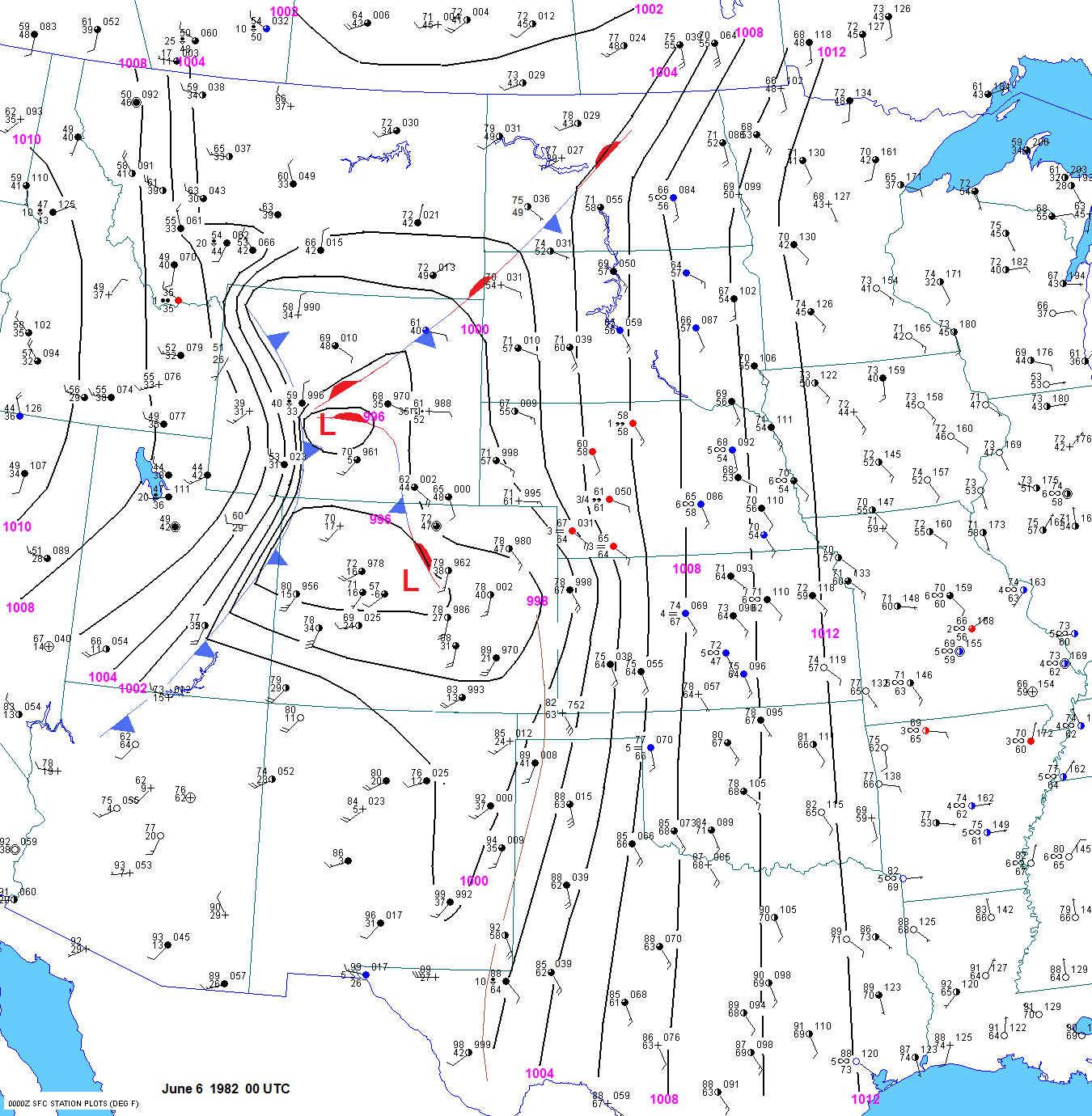
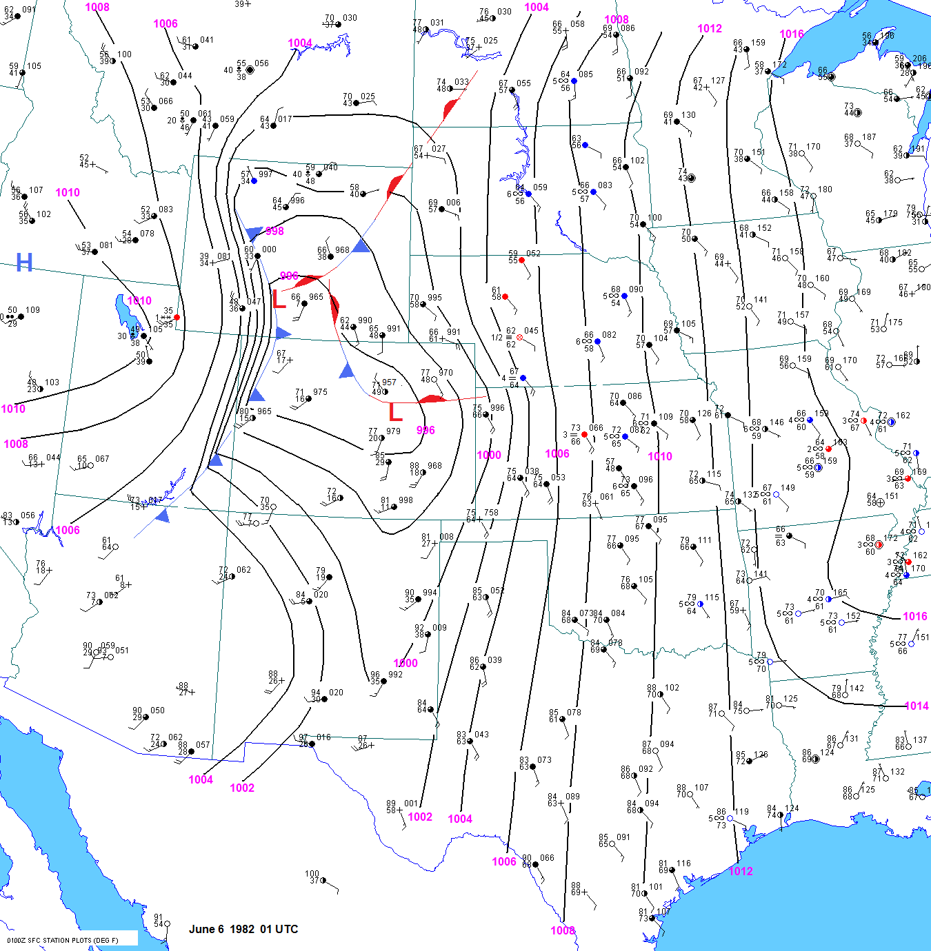
                                        The series of surface maps from 22 to 23 to 00 to 01 to 02 UTC indicated that surface dewpoints were likely around 58F
                                        in the Lance Creek area by 0230 UTC. The elevation of Lance Creek is about 4500ft. The surface temperature was
                                        probably about 66F. Plugging these values into
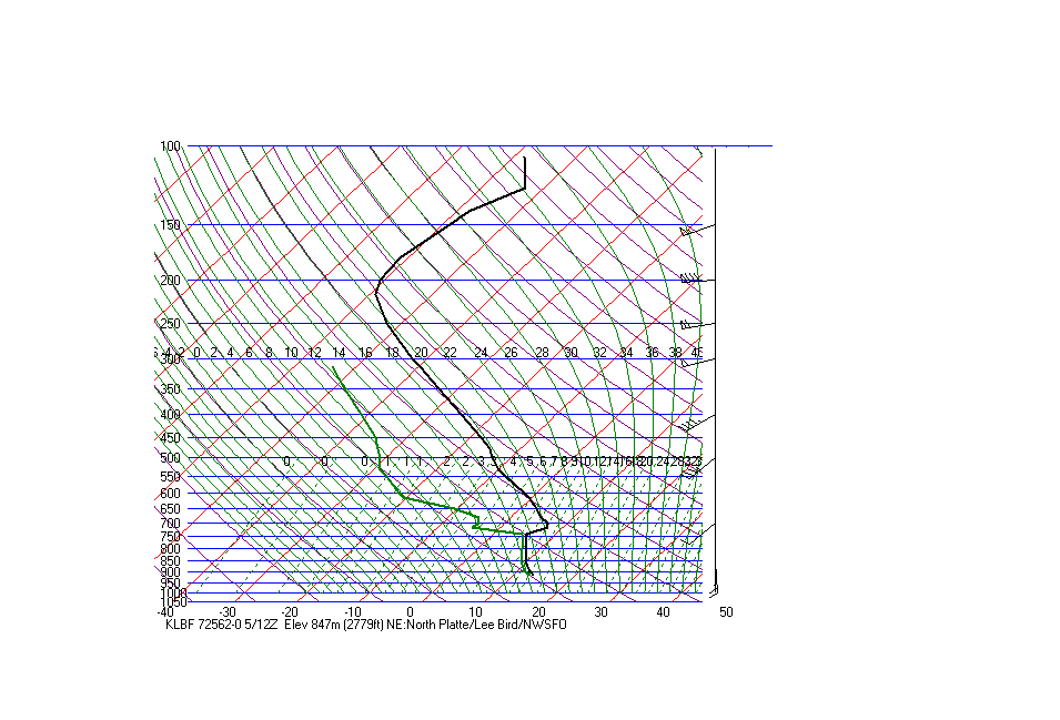
 the 00 UTC Rapid City sounding yields 2900 j/kg surface based CAPE.
                                        Keep in mind that the starting pressure for the modified Rapid City sounding was adjusted upward to 853 mb.
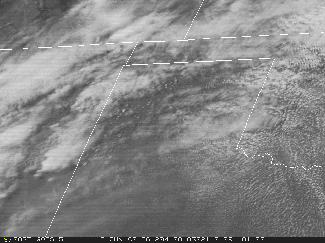
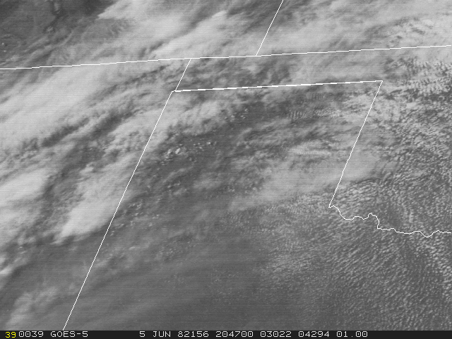
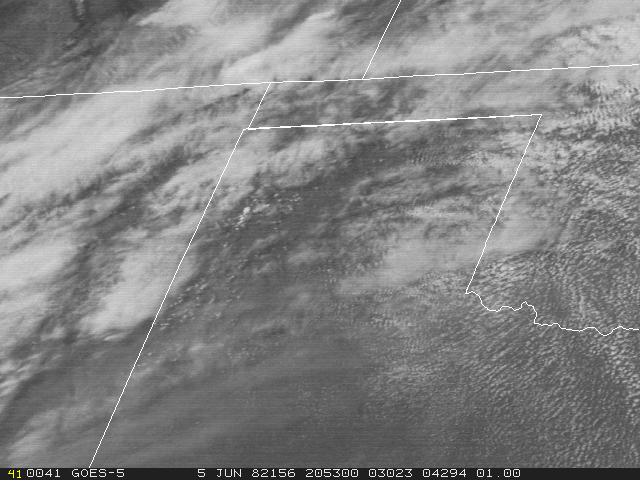
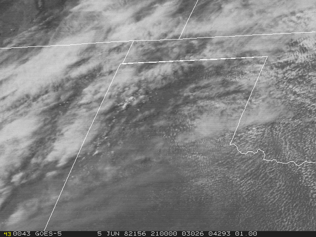
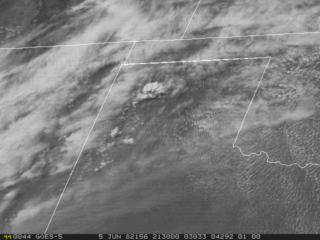
                                        The GOES west and GOES east visible loops over Wyoming are impressive.

                                        From the visible loop, one can see explosive nature of the storms in the Texas panhandle between 2100 and 2300 UTC.
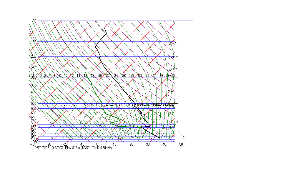
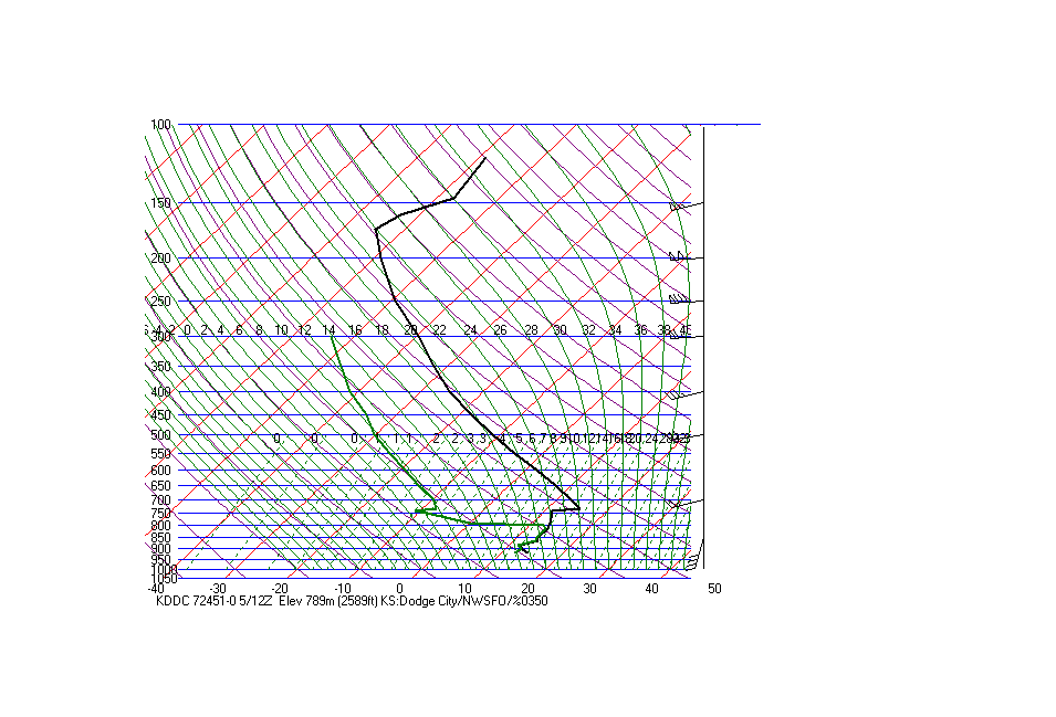
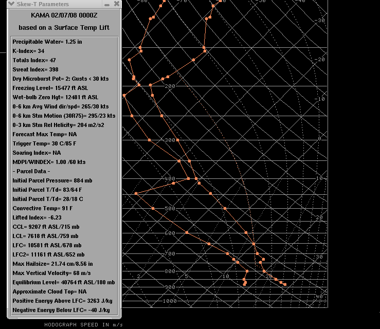
                                        Surface based CAPE at Amarillo was estimated using 21 to 00 UTC surface observations and the 00 UTC Amarillo
                                        sounding. The surface based CAPE was 3000 j/kg. The sounding apparently went into a storm anvil around 400mb.                                                                             
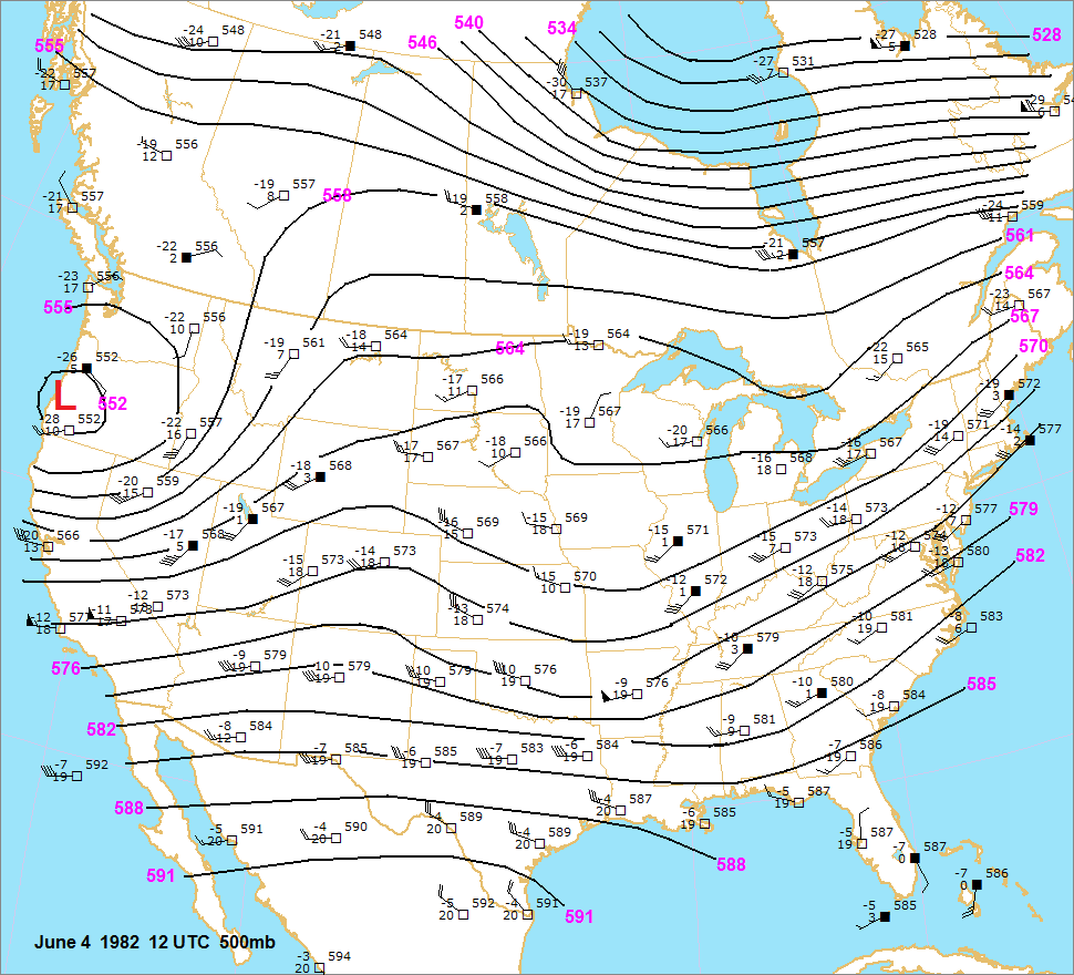
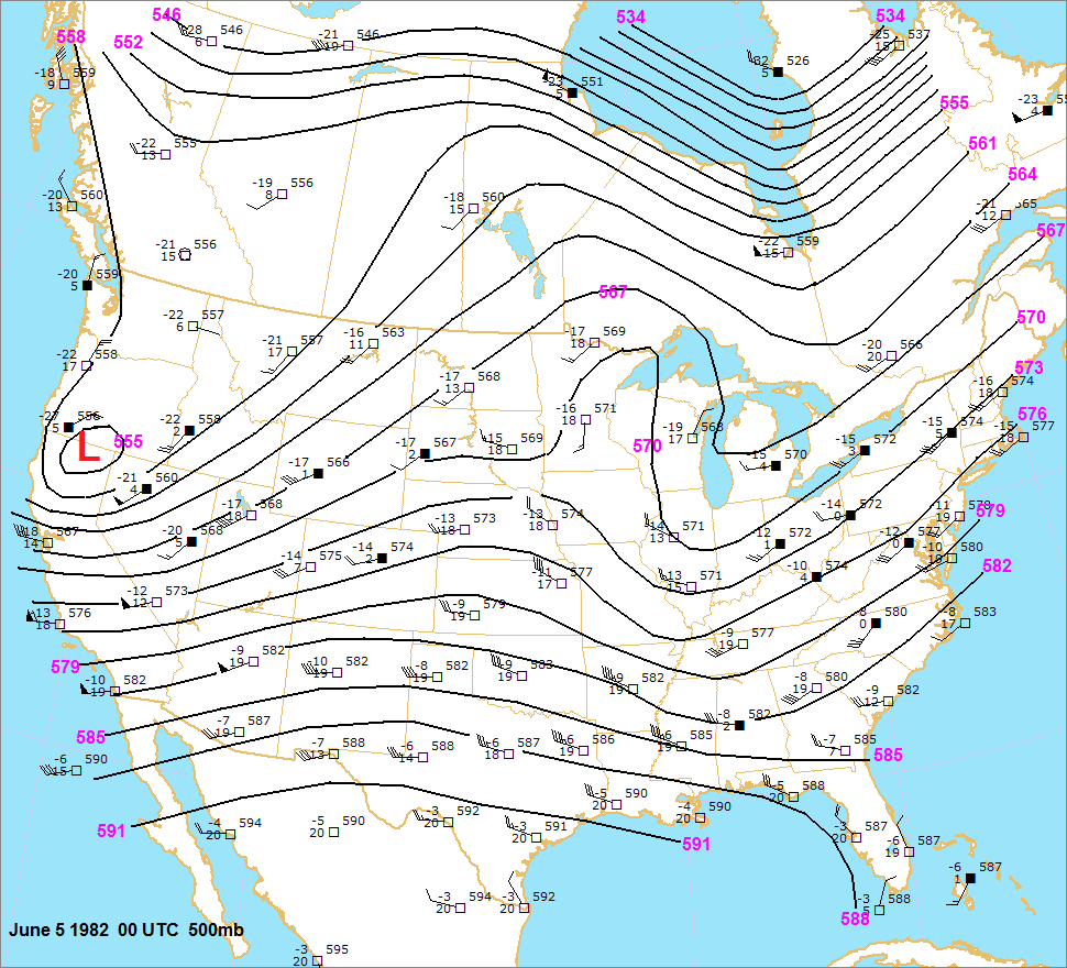
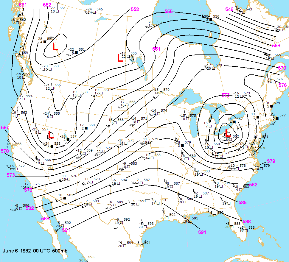
                                        The 00 UTC upper air charts showed a strong jet streak by early June standards over Utah, with central and northeast
                                        northeast Wyoming in the left front quadrant. This helps explain why storms were more widespread in this region. Above
                                        the Rockies boundary layer, the mid to high level flow was quite strong across central and northeast Wyoming. The
                                        500mb winds were probably weaker because of frictional effects of the deep Rockies boundary layer. This is often the
                                        case in the summer. If course, the 500mb level is really not that high at places like Rawlins, Laramie, Rock Springs,
                                        Eagle, Leadville and the mountains of central Colorado. When a strong trough is approaching the Rockies in summer,
                                        the 400mb winds are often quite a bit stronger than the 500mb winds. The
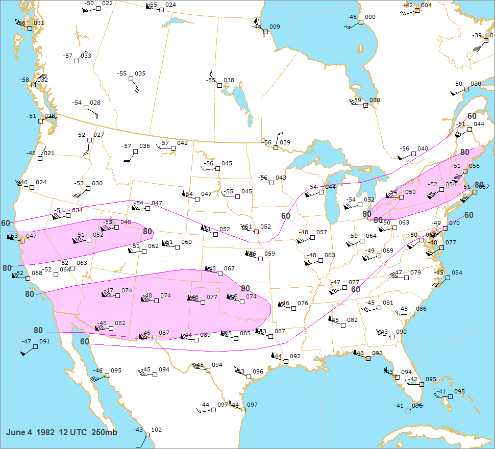
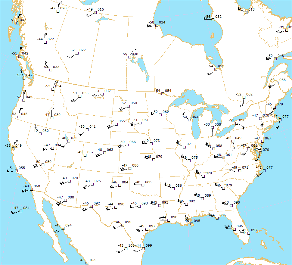
 250 and 300mb charts show central and
                                        northeast Wyoming in the left front quadrant of an impressive jet streak. The 
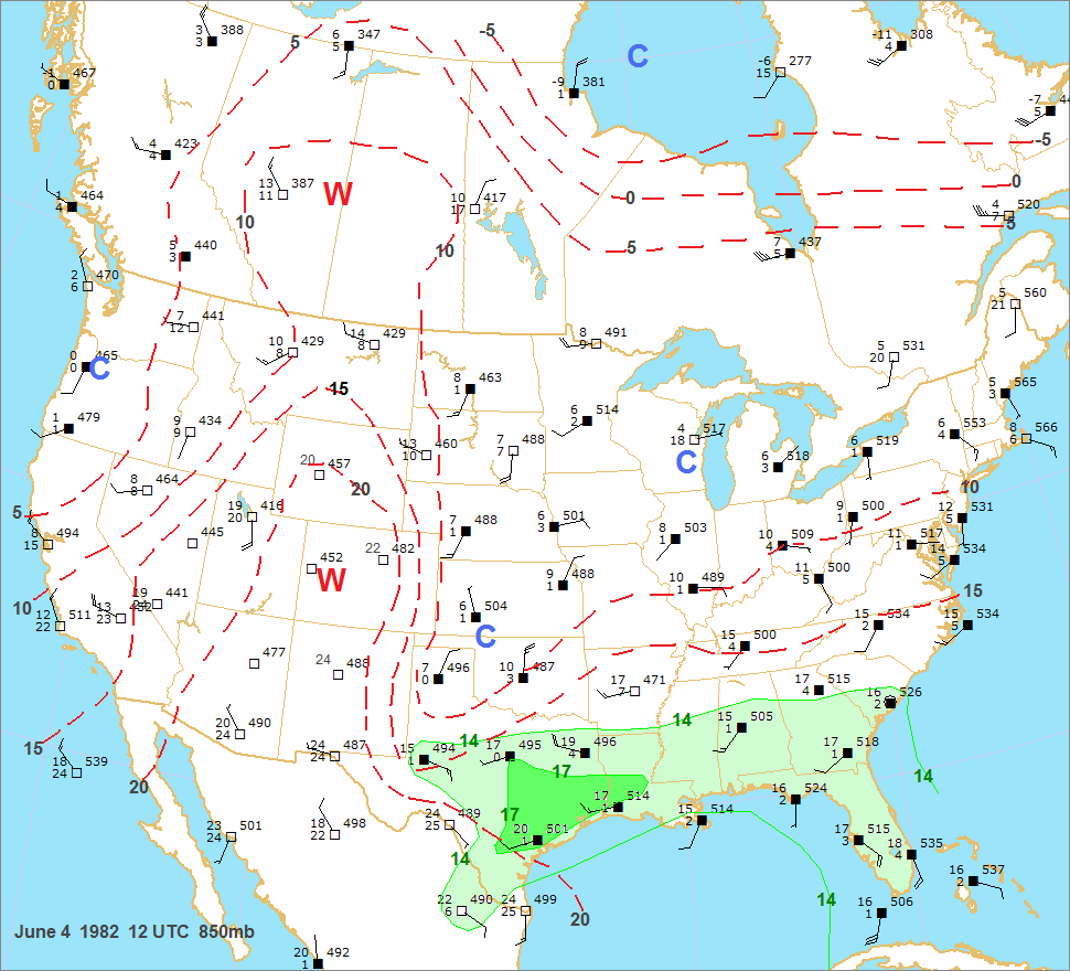
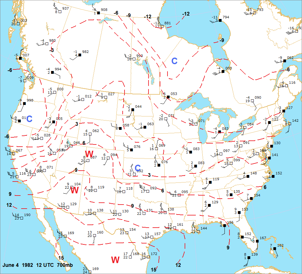
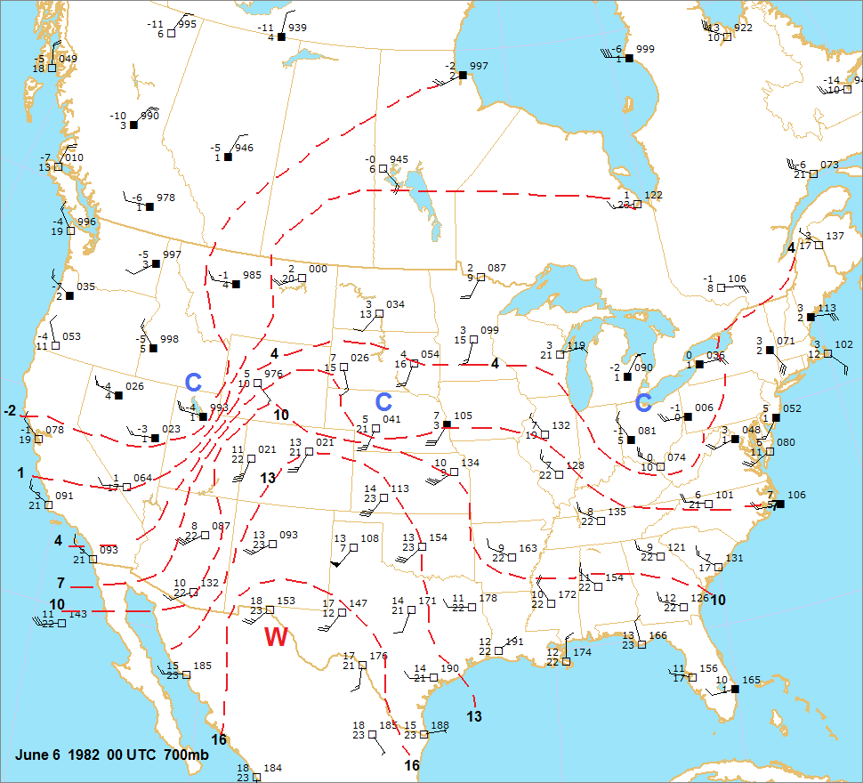
700mb chart showed a strong baroclinic
                                        zone between Salt Lake City and southwest Wyoming.
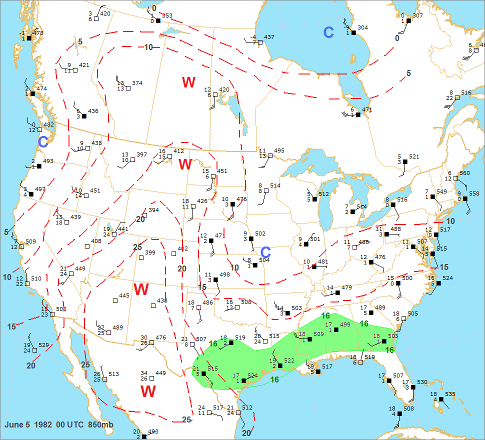
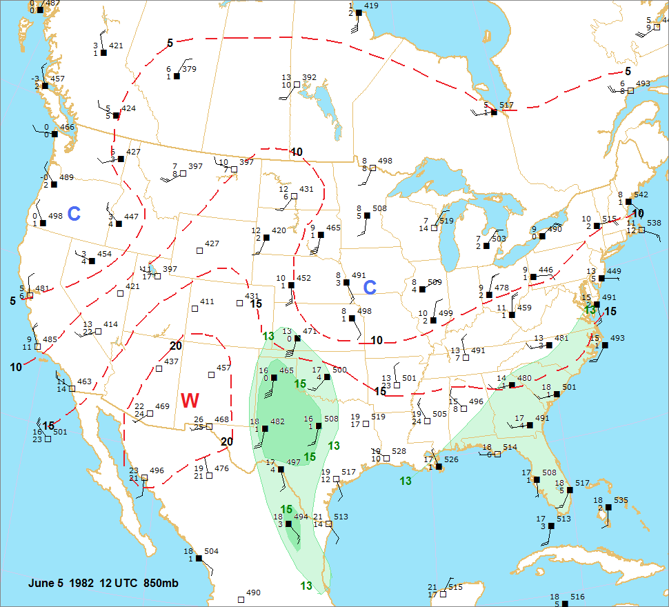
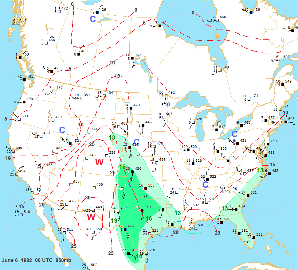
 The 00 UTC 850mb chart indicated rich moisture in place from
                                        west Texas into western Nebraska. The 12 and 00 UTC upper air charts suggest a branch of the jet across the southern
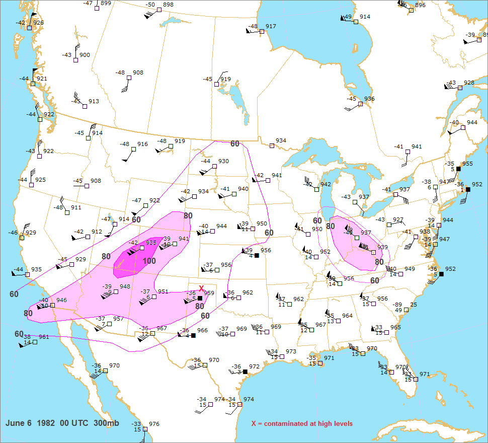
                                        plains. Unfortunately the 00 UTC sounding from Amarillo was contaminated above 400mb so the 300mb wind of
                                        75 kts is suspect. Was the actual windspeed higher than 75 kts? There is no way of knowing.